Potomac River facts for kids
Quick facts for kids Potomac River |
|
|---|---|

|
|

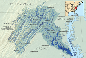
The Potomac River watershed covers the District of Columbia and parts of four states
|
|
| Native name | Patawomeck |
| Country | United States |
| State | West Virginia, Maryland, Virginia, District of Columbia |
| Cities | Cumberland, MD, Harpers Ferry, WV, Washington, D.C., Alexandria, VA |
| Physical characteristics | |
| Main source | Fairfax Stone Preston County, West Virginia, United States 3,060 ft (930 m) 39°11′43″N 79°29′28″W / 39.19528°N 79.49111°W |
| River mouth | Chesapeake Bay St. Mary's County, Maryland/Northumberland County, Virginia, United States 0 ft (0 m) 37°59′57″N 76°14′59″W / 37.99917°N 76.24972°W |
| Length | 405 mi (652 km) |
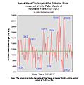
| Discharge (location 2) |
|
| Discharge (location 3) |
|
| Discharge (location 4) |
|
| Basin features | |
| Basin size | 14,700 sq mi (38,000 km2) |
| Tributaries | |
| ------------------------------------------------------------------ Note: Since 1996, the Potomac has been the 'sister river' of the Ara River of Tokyo, Japan |
|
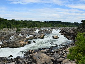
The Potomac River is found within the Mid-Atlantic region of the United States and flows from the Potomac Highlands into the Chesapeake Bay. The river (main stem and North Branch) is approximately 405 miles (652 km) long, with a drainage area of about 14,700 square miles (38,000 km2). In terms of area, this makes the Potomac River the fourth largest river along the Atlantic coast of the United States and the 21st largest in the United States. Over 5 million people live within the Potomac watershed.
The river forms part of the borders between Maryland and Washington, D.C., on the left descending bank and West Virginia and Virginia on the river's right descending bank. The majority of the lower Potomac River is part of Maryland. Exceptions include a small tidal portion within the District of Columbia, and the border with Virginia being delineated from "point to point" (thus various bays and shoreline indentations lie in Virginia). Except for a small portion of its headwaters in West Virginia, the North Branch Potomac River is considered part of Maryland to the low water mark on the opposite bank. The South Branch Potomac River lies completely within the state of West Virginia except for its headwaters, which lie in Virginia.
Images for kids
-
The Potomac River in Washington, D.C., with Arlington Memorial Bridge in the foreground and Rosslyn, Arlington, Virginia in the background
-
The North Branch between Cumberland, Maryland, and Ridgeley, West Virginia, in 2007
-
Canoers at Hanging Rocks on the South Branch in the 1890s
-
View southwest across the tidal Potomac River from the south end of Cobb Island Road on Cobb Island, Charles County, Maryland
-
View of the Potomac River from George Washington's birthplace in Westmoreland County, Virginia
-
Sunset over the Potomac near Mount Vernon
-
The Potomac River surges over the deck of Chain Bridge during the historic 1936 flood. The bridge was so severely damaged by the raging water, and the debris it carried, that its superstructure had to be re-built; the new bridge was opened to traffic in 1939. (This photograph was taken from a vantage point on Glebe Road in Arlington County, Virginia. The houses on the bluffs in the background are located on the Potomac Palisades of Washington, DC.)
-
Eutrophication in the Potomac River is evident from this bright green water in Washington, D.C., caused by a dense bloom of cyanobacteria, April 2012
-
The South Branch near South Branch Depot, West Virginia
-
Confluence of the Cacapon River (barely visible) with the Potomac
-
Oblique air photo, facing southwest, of the Potomac River flowing through water gaps in the Blue Ridge Mountains. Virginia on the left, Maryland on the right, West Virginia in upper right, including Harpers Ferry (partially obscured by Maryland Heights of Elk Ridge Mountain) at the confluence of the Potomac and Shenandoah Rivers.
-
Potomac River at Goose Creek
-
The Great Falls of the Potomac, viewed from the Virginia bank of the river (Engraving based on an aquatint drawn by George Jacob Beck in 1802)
-
View of the Potomac River, Analostan Island, Georgetown, and, in the distance, buildings of the nascent City of Washington. (Engraving based on an 1801 watercolor by George Jacob Beck)
-
Jefferson Memorial in Washington, D.C., viewed from across the Tidal Basin of the Potomac
-
The Pentagon, looking northeast with the Potomac in the distance
-
East Branch of the Potomac (now called the Anacostia River) near its confluence with the mainstem Potomac in Washington. (Watercolor drawn in 1839 by Augustus Kollner)
-
View of the Potomac from Mount Vernon
-
Potomac River seen while landing at Reagan National Airport
-
View northeast down the North Branch Potomac River from the Gorman-Gormania Bridge (U.S. Route 50) between Gormania, Grant County, West Virginia and Gorman, Garrett County, Maryland
See also
 In Spanish: Río Potomac para niños


