Perejil Island facts for kids
| Disputed island Native name: Isla Perejil Tura / Toṛa تورة Parsley Island |
|
|---|---|
 |
|
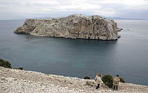
| View of Perejil Island from the Moroccan coast with Spain on the horizon | |
| Geography | |
| Location | Strait of Gibraltar |
| Coordinates | 35°54′50″N 5°25′08″W / 35.91389°N 5.41889°W |
| Total islands | 1 |
| Area | 15 hectares (37 acres) |
| Highest point | 74 metres (243 ft) |
| Administered by | |
| Claimed by | |
| Demographics | |
| Population | Uninhabited |

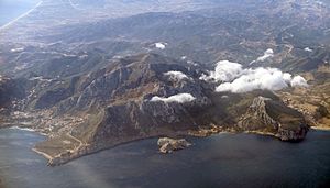
Perejil Island (Spanish: Isla de Perejil, Berber: Tura or Toṛa, Arabic: تورة, romanized: Tūra), also known as Parsley Island, is a small, uninhabited rocky islet located off the coast of Morocco, just 200 metres (660 ft) from the mainland coast. Its sovereignty is disputed between Spain and Morocco. It was the subject of an armed incident between the two countries in 2002.
Name
The name Isla de Perejil literally means "Parsley Island" in Spanish. Its original Berber name is Tura, meaning "empty". Moroccan and international media often mistakenly use the name Laila (Arabic: ليلى) due to a confusion resulting from it being referred to as "la isla" ("the island") pronounced in Spanish with Andalusian accent, rendering "lah ihla" or laíla. It is sometimes referred to in Arabic as "Jazirat al-Ma'danus" (Arabic: جزيرة معدنوس), which is a translation of "Parsley Island".
In Moroccan historical references it is only known as "Tura". In his speech to the Moroccan people commemorating the "Throne Day" on 30 July 2002, the King of Morocco used the name "Tura" exclusively, when he mentioned the armed incident with Spain over the island.
Geography
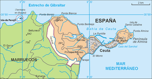
The island lies 250 metres (820 feet) off the coast of Morocco, 3 kilometres (2 miles) from the border of the territory of the Spanish city of Ceuta, 8 km (5.0 miles) to Ceuta itself and 13.5 km (8.4 miles) from mainland Spain. The island is about 480 by 480 metres (1,575 by 1,575 feet) in size, with an area of 15 ha or 0.15 square kilometres (0.06 sq mi). It has a maximum height of 74 metres (243 feet) above sea level.
History
In 1415, Portugal, along with the conquest of Ceuta, took possession of the nearby islet from Morocco. In 1580, Portugal came under the sovereignty of Philip I of Portugal, who was also King of Spain, creating an Iberian Union under one king, without unifying the countries. When the Union split in 1640, Ceuta remained under Spanish sovereignty.
The islet's sovereignty is disputed by Morocco and Spain. Local Moroccan shepherds used it for grazing of livestock, but the vast majority of Spaniards and Moroccans had not heard of the islet until 11 July 2002, when a group of Moroccan soldiers set up a base on the islet. The Moroccan government said that they set foot on the island in order to monitor illegal immigration, a justification the Spanish government rejected as there had been little co-operation on the matter at the time (a repeated source of complaint from Spain). After protests from the Spanish government, led by Prime Minister José María Aznar, Morocco replaced the soldiers with cadets from the Moroccan Navy, who then installed a fixed base on the island. This further angered the Spanish government and both countries restated their claims to the islet. Almost all European Union member states fully supported Spain's objections, with the exception of France and Portugal, whose government issued a statement regretting the incident. Morocco's claims had official support from the Arab League, except for Algeria, which restated its recognition of Spanish sovereignty over the exclaves of Ceuta and Melilla.
On the morning of 18 July 2002 Spain launched Operation Romeo-Sierra, a military attempt to take over the island. The operation was successful and within hours the Spanish had taken control of the island and custody of the Moroccan naval cadets, who had not resisted the Spanish commando attack force, Grupo de Operaciones Especiales III. The operation was launched in conjunction with the Spanish Navy and Spanish Air Force. The Spanish transferred the captured Moroccans by helicopter to the headquarters of the Guardia Civil in Ceuta, who then transported the cadets to the Moroccan border. Over the course of the same day, the Spanish Legion replaced the commandos and remained on the island until Morocco, after mediation by the United States, led by Colin Powell, agreed to return to the status quo ante which existed prior to the Moroccan occupation of the island. The islet is now deserted.
Sovereignty
Perejil Island has no permanent human population. Goats are pastured there, and the Moroccan government expressed worries that smugglers and terrorists, in addition to illegal immigrants, were using the island. The island is well monitored from both sides in order to maintain the status quo that leaves it deserted and virtually a no man's land.
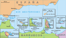
Morocco had demanded the return of the Spanish cities Ceuta and Melilla along with several small rocks and islets off the coast of Morocco. The crisis over Perejil Island was seen by the Spanish government as a way for Morocco to test the waters in regard to Spain's will to defend Ceuta and Melilla.
Migration
In June 2014, Spain requested that the Moroccan forces enter the island to expel sub-Saharan migrants.
See also
 In Spanish: Isla de Perejil para niños


