
Patnitop facts for kids
Quick facts for kids
Patnitop
|
|
|---|---|
|
Hill Station
|
|

Patnitop in Winters
|
|

Patnitop
Location in Jammu and Kashmir

Patnitop
Location in India
|
|
| Country | |
| State | Jammu and Kashmir |
| District | Udhampur |
| Elevation | 2,024 m (6,640 ft) |
| Time zone | UTC+5:30 (IST) |
| PIN |
182142
|
Patnitop or Patni Top is a hilltop tourist location in Udhampur district in Jammu and Kashmir state of India, on the Jammu-Srinagar National Highway (which is part of National Highway 44, formerly 1A), 112 km (70 mi) from Jammu on the way from Udhampur to Srinagar. Situated on a plateau in the Shivalik belt of the Himalayas, Patnitop sits at an altitude of 2,024 m (6,640 ft). The river Chenab flows in close proximity to this location.
Patnitop bypass road tunnel
Snowfall and avalanche in winter at Patnitop obstructs the Jammu-Srinagar National Highway a few times every winter and causes long queues of vehicles, sometimes for days. These problems were partly mitigated by the opening of the Chenani-Nashri Tunnel or Patnitop Tunnel. At 9.2 km (6 mi), it is India's longest road tunnel. It starts from about 2 km (1 mi) from Chenani town south of Patnitop to Nashri village north of Patnitop, reducing the distance from Jammu to Srinagar by 31 km (19 mi) and bypassing Patnitop.
Gallery
-
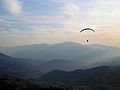
Paragliding at Patnitop
-
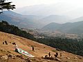
Dawariyai take off area at Patnitop
-
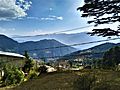
Patnitop Mountains


Images for kids
-
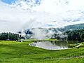
Sanasar Lake

