Paint Rock, Texas facts for kids
Quick facts for kids
Paint Rock, Texas
|
|
|---|---|
|
Town
|
|

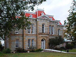
The Concho County Courthouse in Paint Rock
|
|

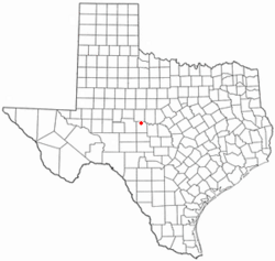
Location of Paint Rock, Texas
|
|
 |
|
| Country | United States |
| State | Texas |
| County | Concho |
| Area | |
| • Total | 1.64 sq mi (4.26 km2) |
| • Land | 1.64 sq mi (4.26 km2) |
| • Water | 0.00 sq mi (0.00 km2) |
| Elevation | 1,631 ft (497 m) |
| Population
(2020)
|
|
| • Total | 237 |
| • Density | 144.51/sq mi (55.63/km2) |
| Time zone | UTC-6 (Central (CST)) |
| • Summer (DST) | UTC-5 (CDT) |
| ZIP code |
76866
|
| Area code(s) | 325 |
| FIPS code | 48-54636 |
| GNIS feature ID | 2413100 |
Paint Rock is a town in and the county seat of Concho County, Texas, United States. The population was 237 at the 2020 census.
The town's name comes from Native American pictographs painted on cliffs overlooking the nearby Concho River. These pictographs cover nearly half a mile upstream from the town of Paint Rock. Some of the pictures painted on the rocks include animals, human figures, and handprints. A few of the pictographs there were made by the Comanche, who likely used the bluff as a camp site; they may have also fought the Texas Rangers there. They are located on a private ranch, property of the Cambell family who protect them and organizes tours for visitors.
Contents
Geography
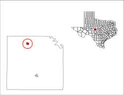
Paint Rock is located in northern Concho County along U.S. Route 83. Eden is 20 miles (32 km) to the south and Ballinger is 16 miles (26 km) to the north via US 83, while San Angelo is 32 miles (51 km) to the west via secondary roads.
According to the United States Census Bureau, the town of Paint Rock has a total area of 1.64 square miles (4.26 km2), all land.
Demographics
| Historical population | |||
|---|---|---|---|
| Census | Pop. | %± | |
| 1890 | 323 | — | |
| 1970 | 193 | — | |
| 1980 | 256 | 32.6% | |
| 1990 | 227 | −11.3% | |
| 2000 | 320 | 41.0% | |
| 2010 | 273 | −14.7% | |
| 2020 | 237 | −13.2% | |
| U.S. Decennial Census | |||
2020 census
| Race | Number | Percentage |
|---|---|---|
| White (NH) | 170 | 71.73% |
| Black or African American (NH) | 1 | 0.42% |
| Some Other Race (NH) | 2 | 0.84% |
| Mixed/Multi-Racial (NH) | 7 | 2.95% |
| Hispanic or Latino | 57 | 24.05% |
| Total | 237 |
As of the 2020 United States census, there were 237 people, 109 households, and 94 families residing in the town.
Education
The town is served by the Paint Rock Independent School District.
Climate
The climate in this area is characterized by hot, humid summers and generally mild to cool winters. According to the Köppen climate classification system, Paint Rock has a humid subtropical climate, Cfa on climate maps.
| Climate data for Paint Rock, Texas (1991–2020 normals, extremes 1963–present) | |||||||||||||
|---|---|---|---|---|---|---|---|---|---|---|---|---|---|
| Month | Jan | Feb | Mar | Apr | May | Jun | Jul | Aug | Sep | Oct | Nov | Dec | Year |
| Record high °F (°C) | 89 (32) |
98 (37) |
98 (37) |
104 (40) |
111 (44) |
112 (44) |
111 (44) |
112 (44) |
110 (43) |
103 (39) |
93 (34) |
89 (32) |
112 (44) |
| Mean daily maximum °F (°C) | 60.0 (15.6) |
63.9 (17.7) |
71.4 (21.9) |
80.3 (26.8) |
87.1 (30.6) |
93.2 (34.0) |
96.2 (35.7) |
96.0 (35.6) |
89.0 (31.7) |
80.3 (26.8) |
68.6 (20.3) |
60.3 (15.7) |
78.9 (26.1) |
| Daily mean °F (°C) | 45.2 (7.3) |
49.1 (9.5) |
56.8 (13.8) |
65.3 (18.5) |
73.9 (23.3) |
80.9 (27.2) |
83.7 (28.7) |
83.3 (28.5) |
76.2 (24.6) |
66.1 (18.9) |
54.4 (12.4) |
46.0 (7.8) |
65.1 (18.4) |
| Mean daily minimum °F (°C) | 30.3 (−0.9) |
34.3 (1.3) |
42.2 (5.7) |
50.3 (10.2) |
60.7 (15.9) |
68.5 (20.3) |
71.3 (21.8) |
70.5 (21.4) |
63.4 (17.4) |
51.9 (11.1) |
40.2 (4.6) |
31.7 (−0.2) |
51.3 (10.7) |
| Record low °F (°C) | 2 (−17) |
−8 (−22) |
8 (−13) |
22 (−6) |
35 (2) |
44 (7) |
56 (13) |
51 (11) |
36 (2) |
23 (−5) |
12 (−11) |
−4 (−20) |
−8 (−22) |
| Average precipitation inches (mm) | 1.06 (27) |
1.57 (40) |
1.78 (45) |
1.51 (38) |
3.04 (77) |
3.50 (89) |
2.05 (52) |
2.39 (61) |
2.33 (59) |
2.36 (60) |
1.81 (46) |
1.17 (30) |
24.57 (624) |
| Average precipitation days (≥ 0.01 in) | 4.2 | 4.1 | 4.1 | 3.5 | 7.0 | 5.9 | 4.0 | 4.8 | 4.8 | 4.8 | 4.0 | 3.7 | 54.9 |
| Source: NOAA | |||||||||||||
See also
 In Spanish: Paint Rock (Texas) para niños

