Opawa facts for kids
Quick facts for kids
Opawa
|
|
|---|---|
|
Suburb
|
|
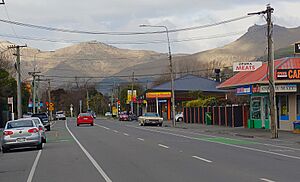
Main retail area on Opawa Road, looking south-east towards Mount Cavendish
|
|
| Country | New Zealand |
| Local authority | Christchurch |
| Electoral ward | Heathcote |
| Area | |
| • Land | 81 ha (200 acre) |
| Population
(June 2023)
|
|
| • Total | 1,320 |
|
|
||
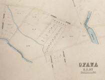
Opawa is an inner residential suburb of Christchurch, New Zealand. It is located approximately 3.5 kilometres (2.2 miles) south-east of the city centre. Initially Opawa was a low-lying area, and a continuation of the Sydenham swamp. By the 1860s, the area was sparsely populated by European settlers and later became a rural-agricultural locality, with many of the early settlers of English descent. As Woolston emerged as an industrial hub nearby, Opawa was heavily urbanised, transforming it into an upscale residential area and its population largely included factory workers and businesspeople. Notable heritage-listed buildings in the suburb include "Risingholme" and "The Hollies". In its formative days, Opawa was a riding of the Heathcote County Council. It later amalgamated in to the city area in 1916.
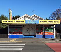
The Māori name for the area is Ōpāwaho and the settlement itself was called Poho-Areare. It was located near the present-day Vincent Place and Judge Street intersection, strategically located to control the river passage to its nearby estuary. Today, the suburb's main roads are Opawa Road and Ensors Road. The main retail area is centred on Opawa Road. It developed on one of the earliest settled routes, at the intersection of Hawford and Reeves Roads. State Highway 76 and the Main South Line are situated further north of the suburb.
At a national level, the suburb is currently part of the Christchurch Central parliamentary electorate. Locally, the suburb is part of the Heathcote Ward for Christchurch City Council local body elections. Opawa contains three primary schools, two kindergartens, a retirement village and a rest home. The suburb is home to the Opawa Bowling Club and the Opawa Lawn Tennis Club. Noted people with Opawa connections include some of the early settlers and several people who were born or educated in the suburb.
History
The Māori name for the area is Ōpāwaho. It is a combination of 'Ō' which means a part of and pā and 'waho' which means outer or outside a defined area. Ōpāwaho (or Opaawaho) is also the name for the lower part of the Heathcote River. There was a kāinga located near the present-day Vincent Place and Judge Street intersection. It was used as a resting place for Māori travelling between Kaiapoi Pā and the Banks Peninsula. Māori that lived here used the surrounding swamplands and the river as a source of lamprey and eels. The name of the village itself is Poho-Areare. It is also the name of an early rangatira of the settlement and the name is also applied to a walking track that led from this settlement to South New Brighton. Later, Tūrakipō was the settlement's chief.
Opawa was a low-lying area, and a continuation of the Sydenham swamp. The Māori name for the swamplands which the Heathcote River drained is Te Kuru. Poho-areare was strategically located to control the river passage to the estuary and the ocean, eventually becoming known as Ōpāwaho. Various names rendered the area and Opawa eventually became the established and officially recognised name.
By the 1860s, it was sparsely populated by European settlers and the area south of Linwood and Woolston became a rural-agricultural locality. Early settlers in Opawa were farmers and people of English descent, many of whom came from relatively wealthy families. In Opawa's early years, the centre of the locality was reportedly the corner of Locarno Street and Opawa Road, where the St Mark's Anglican Church is located. Opawa was established around a loop of the Heathcote River, initially where a number of large houses were built on large riverside sections.
As Woolston emerged as an industrial hub nearby, the population of Opawa grew rapidly, transforming it into an upscale residential area. Additionally, it also grew as people left Woolston's industrial areas including factory-workers and businesspeople who could not find homes in Woolston. Opawa suffered some damage in the 2010 Canterbury earthquake. A section of shops along Opawa Road had been closed due to the damage, while the other shops remained operating as usual. And, several homes had been damaged by collapsing chimneys. Opawa is served by the Opawa Library and Opawa Children's Library. These buildings suffered substantial earthquake-related damages. The Opawa Children's Library was able to reopen and operate and the Opawa Library was later rebuilt in 2019.
Geography
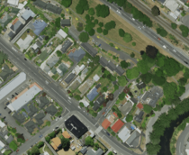
The Rāpaki Track, an old Māori walking track lies nearby. It is located in the eastern flank through St Martins Valley, linking the Canterbury Plains with Rāpaki and Lyttleton Harbour. Today, State Highway 76 (Brougham Street) and the Main South Line traverse north through the suburb. Other suburbs nearby include, Murray Aynsley Hill, Huntsbury, St Martins, Waltham, Hillsborough, and Linwood. The flat area between Opawa and Heathcote Valley enters a substantial locale of industrial businesses. The suburb's main roads are Opawa Road and Ensors Road. The main retail precinct is centred on Opawa Road, it was developed on one of the earliest settled routes, at the intersection of Hawford and Reeves Roads.
In 1967, there were proposals for the Opawa Expressway from Waltham to Tunnel Road, which will affect 307 residential and other properties in the Heathcote County and Christchurch City areas. Maps supplied to the authorities showed the expressway starting at the terminus of the northern and southern motorways near the corner of Shakespeare Road and Waltham Road, running north of Shakespeare Road, alongside the railway from Ensors Road to Garlands Road, and continued along Port Hills Road to Tunnel Road. This project would cause disruption of the residential area during its construction, and 60 properties would be affected. Opawa Road is no longer the primary thoroughfare through to Lyttelton and Heathcote.
The area between Brougham Street and Moorhouse Avenue traversing Waltham and Sydenham accommodates many small businesses and light industrial premises. The Main South Line used to provide one of Christchurch's largest industries the Addington Railway Workshops, in Addington. Woolston also became an industrial centre, positioned on the railway line. The railways had local significance as they stimulated settlement beyond the confines of the "original suburbs". In Opawa, residents had frequent trains to Christchurch passing daily through the district. Opawa is predominantly residential, though it has a light retail precinct centred on Opawa Road.
Opawa is flood-prone suburb. Because of its location next to the Heathcote River, the area has subsequently been flooded numerous times in recent years.
The primary road supporting the transportion in the area is State Highway 76 (Brougham Street) which traverses from the north through the suburb, also through Sydenham and Brougham Street, going thoroughfare the suburbs of Hillsborough and Opawa, then Port Hills Road connecting with Tunnel Road to pass through the Lyttelton road tunnel at Heathcote Valley.
Landmarks
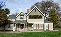
Opawa contains multiple landmarks known for their connection with some of the early European settlers in the area, among them, the Risingholme, which was built in 1864 by Mary and William Reeves. Up until 1943, the building was owned by several private owners. It was later purchased by philanthropist John McKenzie in 1943. The building was gifted to the city council for the "health, amusement and instruction of the public". Established in 1944, it became one of New Zealand's first community centres. It has a Category 2 listing with Heritage New Zealand.
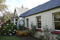
"Fownhope" was built in 1868 its historically significant for its connection with Edward Harley, an English settler, who worked as an accountant, and Frederick Bowler. The house is built from mataī and other native New Zealand trees. The floor in the house is lined with baltic pine, which was brought from Europe. Fownhope has a strong link to early European settlement in the area, and is representative of what many houses were at the time. It has a Category 2 listing with Heritage New Zealand and the Christchurch City Council recognises a "Group 3" listing to the Fownhope.
The Hollies was built in 1871, it is an early colonial house built by English-born mechanice Edward Richardson. Richardson was responsible for overseeing the completion of the Lyttelton rail tunnel. Richardson was born in England where he trained as a civil engineer before emigrating to Christchurch. The building sits fairly close to the eastern boundary facing the Heathcote River. The Hollies is a Category 2 heritage-listed building.
St Mark's Anglican Church is located on Opawa Road. Its foundation stone was laid in May 1865 by Bishop Selwyn, the first Primate of New Zealand. In December 1949 the old St Mark's Anglican Church was destroyed by fire. This severance with the church for many people was one of the few remaining links to Christchurch's early European settlers. A new church was constructed on the same site and reopened four years later in December 1953.
Roxburghe is located on 44 Opawa Road. It was built by businessman William Wombwell Charters in 1879. The building is significant because of it being a fine example of an Italianate villa. The dwelling suffered considerable damage during the 2010–2011 Canterbury earthquakes. New foundations were laid and the building was repaired.
The Fifield located on 14 Hawford Road holds historic significance for its connection with civil engineer William Bray and pharmacist William Townend and his family. The building contains a smoking room, a nursery, and a servants' quarters. After the 2010–2011 Canterbury earthquakes, there was damage to dwelling's chimneys. It partially collapsed and was removed as a result.
Another landmark is an untitled house located on 9 Ford Road. Noted residents here include Otto and Margaret Frankel. This dwelling holds historic significance for its connection with an Austrian architect Ernst Plischke and the significant number of European intellectuals seeking refuge in New Zealand to escape the increasing influence of Nazism in the 1930s. It is also holds significance as it reflects the ideals of in the dwelling's modernist design. It has a Category 2 listing with Heritage New Zealand.
Governance
In its early days, Opawa was a riding of the Heathcote County Council. In December 1915, a deputation from the district presented to the Christchurch City Council asserting that more than seventy out of 210 ratepayers in the area had backed the idea of joining at a public meeting. The spokesperson of the deputation, J. Clarke, argued that the "City could offer much more to the residents of Opawa than the County Council would." Additionally, Clarke stated that the local homeowners were "Quite willing to pay a little more in rates in order to enjoy the city services." George Scott, the chairman of Heathcote and a city councilor, was in favour for the entire county merging with Christchurch as long as its capital value rating could be preserved. It was favoured to amalgamate Opawa to the city area in a proposal in February 1916.
Opawa was incorporated in to the city area in October 1916. Its neighbouring suburb of Woolston remained a self-governing borough until its amalgamation with the city in November 1921. The Christchurch City Council administers Opawa. The suburb is part of the Heathcote Ward for Christchurch City Council local body elections. The current city councillor is Sara Templeton. At a national level, Opawa currently is part of the Christchurch Central parliamentary electorate. The member of parliament is Duncan Webb of the Labour Party.
Demographics
Opawa covers 0.81 km2 (0.31 sq mi). It had an estimated population of 1,320 as of June 2023, with a population density of 1630 people per km2.
| Historical population | ||
|---|---|---|
| Year | Pop. | ±% p.a. |
| 2006 | 1,434 | — |
| 2013 | 1,302 | −1.37% |
| 2018 | 1,365 | +0.95% |
Opawa had a population of 1,365 at the 2018 New Zealand census, an increase of 63 people (4.8%) since the 2013 census, and a decrease of 69 people (−4.8%) since the 2006 census. There were 504 households, comprising 642 males and 723 females, giving a sex ratio of 0.89 males per female. The median age was 47.5 years (compared with 37.4 years nationally), with 219 people (16.0%) aged under 15 years, 186 (13.6%) aged 15 to 29, 621 (45.5%) aged 30 to 64, and 342 (25.1%) aged 65 or older.
Ethnicities were 90.8% European/Pākehā, 6.6% Māori, 1.3% Pasifika, 5.1% Asian, and 2.4% other ethnicities. People may identify with more than one ethnicity.
The percentage of people born overseas was 21.3, compared with 27.1% nationally.
Although some people chose not to answer the census's question about religious affiliation, 52.7% had no religion, 37.8% were Christian, 0.9% were Hindu, 1.1% were Buddhist and 2.2% had other religions.
Of those at least 15 years old, 363 (31.7%) people had a bachelor's or higher degree, and 195 (17.0%) people had no formal qualifications. The median income was $33,300, compared with $31,800 nationally. 222 people (19.4%) earned over $70,000 compared to 17.2% nationally. The employment status of those at least 15 was that 501 (43.7%) people were employed full-time, 180 (15.7%) were part-time, and 30 (2.6%) were unemployed. Many of the early residents of Opawa were businesspeople and factory-workers who could not find homes in Woolston.
Education
Opawa has no secondary schools, although it does contain three primary schools and two kindergartens. Opawa School, one of North Canterbury's oldest schools, is located on Ford Road. In 1920, foundation of a new school at Opawa was laid. Today, Opawa School (Te Kura o Ōpāwaho) is a full-primary school for years 1 to 8, with a roll of 313 students. The school initially opened in 1872. There are two kindergartens in the suburb, one located on Cholmondeley Avenue and another kindergarten located on Butler Street.
Christchurch Rudolf Steiner School, a state-integrated composite school for years 1 to 13, located on Ombersley Terrace and has a roll of 328 students. The school opened in 1975 and became state-integrated in 1989. St Mark's School is an Anglican state-integrated full primary school for years 1 to 8, it is located on Cholmondeley Avenue. It has a roll of 218 students. It was established in 1921. The nearest secondary school is in Phillipstown located on Aldwins Road, Te Aratai College (formerly Linwood College) situated 2.5 km (1.6 mi) to the north. All these schools are co-educational. Rolls are as of February 2024.
Amenities
Opawa is home to the Opawa Bowling Club and the Opawa Lawn Tennis Club. The Opawa Bowling Club had its fiftieth jubilee in March 1958. The Alpine Ice Centre is located nearby on Brougham Street is Christchurch's main ice sports venue. It hosts the Canterbury Red Devils.
The suburb is located approximately 3.7 km (2.3 mi) from Lancaster Park, in Waltham. Christchurch's main former sporting venue and has since been transformed into a public park with facilities for community sport. Recreational parks in Opawa include Risingholme Park and Hansens Park.
A particularly notable park in Opawa is Hansens Park. Initially the site of a former rubbish dump, there was later plans to transform the landfill site into a park in 1959. Hansen Park contains the clubrooms of the Port Hills Athletic Club. There are two rugby fields and two football fields in the park.
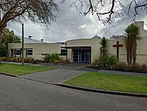
Local businesses in Opawa include a café, a bakery, a butchery, a dairy, a pharmacy, and an op-shop. Additionally, more shops are also located on Ferry Road 2 kilometres (1.2 miles) to the north, in Woolston. Opawa also contains a retirement village and a rest home. In addition to the Saint Marks Anglican Church, another church in Opawa is the Opawa Community Church, located on the corner of Opawa Road and Aynsley Terrace.
Notable people
Notable people with Opawa connections include many of whom were born in the suburb and some were the suburb's early settlers.
- Noeline Baker (1878–1958), an administrator of women's labour in wartime and educator, born in Opawa.
- Alfred William Buxton (1872–1950), a landscape gardener and nurseryman
- John B. Condliffe (1891–1981), an economist and university professor, attended Opawa School.
- Margaret Frankel (1902–1997), a painter, printmaker and art teacher
- Otto Frankel (1900–1998), an Austrian-born geneticist
- Kennaway Henderson (1879–1960), an illustrator and cartoonist
- Ivan Mauger (1939–2018), a motorcycle speedway rider, attended Opawa School
- Robert Page (1897–1957), an industrial chemist
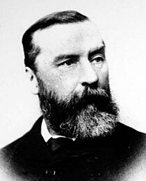
- William Reeves (1823–1891), a businessman and politician who built in 1864 and resided in a house known as "Risingholme".
- William Pember Reeves (1857–1932), politician, cricketer, and historian
- Mollie Tripe (1870–1939), an artist and art teacher, born in Opawa
- Joshua Strange Williams (1837–1915), a politician and judge, an early settler in Opawa.
- Wilfred Stanley Wallis (1891–1957), an orthopaedic surgeon and chief, born in Opawa.
- Anthony Wilding (1883–1915) is one of New Zealand's most successful tennis players in the international class, born in Opawa.
- Robin Williams (1919–2013), an academic administrator and mathematician


