Oglethorpe County, Georgia facts for kids
Quick facts for kids
Oglethorpe County
|
|||
|---|---|---|---|

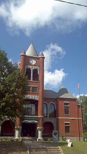
Oglethorpe County Courthouse
|
|||
|
|||

Location within the U.S. state of Georgia
|
|||
 Georgia's location within the U.S. |
|||
| Country | |||
| State | |||
| Founded | December 19, 1795 | ||
| Named for | James Oglethorpe | ||
| Seat | Lexington | ||
| Largest city | Crawford | ||
| Area | |||
| • Total | 442 sq mi (1,140 km2) | ||
| • Land | 439 sq mi (1,140 km2) | ||
| • Water | 3.0 sq mi (8 km2) 0.7%% | ||
| Population
(2020)
|
|||
| • Total | 14,825 | ||
| • Density | 34/sq mi (13/km2) | ||
| Time zone | UTC−5 (Eastern) | ||
| • Summer (DST) | UTC−4 (EDT) | ||
| Congressional district | 10th | ||
Oglethorpe County is a county located in the northeastern part of the U.S. state of Georgia. As of the 2020 census, the population was 14,825. The county seat is Lexington.
Oglethorpe County is included in the Athens-Clarke County, GA Metropolitan Statistical Area, which is also included in the Atlanta-Athens-Clarke County-Sandy Springs, GA Combined Statistical Area. It is the largest county in Northeast Georgia.
Contents
History
Oglethorpe County was originally part of a large tract of land surrendered by Creek and Cherokee Native Americans to the Colony of Georgia in the treaty of 1773. The county itself was founded on December 19, 1793, and is named for Georgia's founder, General James Oglethorpe.
Geography
According to the U.S. Census Bureau, the county has a total area of 442 square miles (1,140 km2), of which 439 square miles (1,140 km2) is land and 3.0 square miles (7.8 km2) (0.7%) is water.
The majority of Oglethorpe County is located in the Broad River sub-basin of the Savannah River basin. A narrow western portion of the county, in a line from just north of Woodville, through Crawford, to just south of Winterville, is located in the Upper Oconee River sub-basin of the Altamaha River basin. A small part of the southern portion of the county, from Maxeys east, is located in the Little River sub-basin of the Savannah River basin.
Major highways
River
Adjacent counties
- Elbert (northeast)
- Wilkes (east)
- Taliaferro (southeast)
- Greene (south)
- Oconee (west)
- Clarke (west)
- Madison (north)
National protected area
- Oconee National Forest (part)
- Watson Mill Bridge State Park (part)
Communities
Demographics
| Historical population | |||
|---|---|---|---|
| Census | Pop. | %± | |
| 1800 | 9,780 | — | |
| 1810 | 12,297 | 25.7% | |
| 1820 | 14,046 | 14.2% | |
| 1830 | 13,618 | −3.0% | |
| 1840 | 10,868 | −20.2% | |
| 1850 | 12,259 | 12.8% | |
| 1860 | 11,549 | −5.8% | |
| 1870 | 11,782 | 2.0% | |
| 1880 | 15,400 | 30.7% | |
| 1890 | 16,951 | 10.1% | |
| 1900 | 17,881 | 5.5% | |
| 1910 | 18,680 | 4.5% | |
| 1920 | 20,287 | 8.6% | |
| 1930 | 12,927 | −36.3% | |
| 1940 | 12,430 | −3.8% | |
| 1950 | 9,958 | −19.9% | |
| 1960 | 7,926 | −20.4% | |
| 1970 | 7,598 | −4.1% | |
| 1980 | 8,929 | 17.5% | |
| 1990 | 9,763 | 9.3% | |
| 2000 | 12,635 | 29.4% | |
| 2010 | 14,899 | 17.9% | |
| 2020 | 14,825 | −0.5% | |
| 2023 (est.) | 15,754 | 5.7% | |
| U.S. Decennial Census 1790-1880 1890-1910 1920-1930 1930-1940 1940-1950 1960-1980 1980-2000 2010 |
|||
| Race | Num. | Perc. |
|---|---|---|
| White | 10,903 | 73.54% |
| Black or African American | 2,248 | 15.16% |
| Native American | 40 | 0.27% |
| Asian | 134 | 0.9% |
| Pacific Islander | 5 | 0.03% |
| Other/Mixed | 626 | 4.22% |
| Hispanic or Latino | 869 | 5.86% |
As of the 2020 United States census, there were 14,825 people, 5,651 households, and 3,711 families residing in the county.
Education
Recreation
- White Water Rafting on the Broad and South Fork Broad Rivers
- ATV and Motor Bike Park
- Sportsman Hunting: Seasonal Whitetail Deer, Turkey and Rabbit
Historic Districts and Heritage Research, Antique Stores in Historic Lexington, Agriculture and Agritourism as well as Oglethorpe Fresh Produce
In 2016, the Oglethorpe County Recreation Department was named both the District 7 and State Agency of the Year for populations under 20,000 through the Georgia Recreation and Park Association.
Transportation
Major highways
Pedestrians and cycling
The county has limited walkability options available.
Notable people
- Nathan Crawford Barnett, member of the Georgia House of Representatives and Georgia Secretary of State for more than 30 years. Raised in Lexington, and educated at the Lexington Academy
- William H. Crawford (1772–1834) - U.S. Minister to France, U.S. Secretary of War, and U.S. Secretary of the Treasury
- George R. Gilmer (1790–1859) - Twice Governor
- Meriwether Lewis (1774–1809) - leader of the Lewis and Clark Expedition
- Wilson Lumpkin (1783–1870) - Governor
- Joseph H. Lumpkin (1799–1867) First Chief Justice of the Georgia Supreme Court and co-founder of the Lumpkin Law School
- George Mathews (1739–1812) - Revolutionary hero and twice Governor
- Kenny Rogers - Country music performer
See also
 In Spanish: Condado de Oglethorpe para niños


