
National Register of Historic Places listings in Spartanburg County, South Carolina facts for kids

This is a list of the National Register of Historic Places listings in Spartanburg County, South Carolina.
This is intended to be a complete list of the properties and districts on the National Register of Historic Places in Spartanburg County, South Carolina, United States. The locations of National Register properties and districts for which the latitude and longitude coordinates are included below, may be seen in a map.
There are 73 properties and districts listed on the National Register in the county. Another 4 properties were once listed but have been removed.
Current listings
| Name on the Register | Image | Date listed | Location | City or town | Description | |
|---|---|---|---|---|---|---|
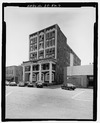
| 1 | Alexander House |
 |
(#03000205) |
319 E. Main St. 34°57′03″N 81°55′28″W / 34.950833°N 81.924444°W |
Spartanburg | |
| 2 | American Legion Building |
 |
(#03000271) |
94 W. Park Dr. 34°56′03″N 81°54′51″W / 34.934167°N 81.914167°W |
Spartanburg | |
| 3 | Anderson's Mill |
.jpg) |
(#78002529) |
West of Spartanburg off South Carolina Highway 296 34°52′59″N 82°00′42″W / 34.883056°N 82.011667°W |
Spartanburg | |
| 4 | Apalache Mill |
 |
(#15000616) |
2200 Racing Rd. 34°57′44″N 82°12′30″W / 34.962312°N 82.208289°W |
Greer | |
| 5 | Arcadia Mill No. 1 |
 |
(#14000819) |
1875 Hayne St. 34°57′25″N 81°59′34″W / 34.9570°N 81.9927°W |
Spartanburg | |
| 6 | Arcadia Mill No. 2 |
 |
(#05001158) |
100 W. Cleveland St. 34°57′26″N 82°00′00″W / 34.957222°N 82.0°W |
Spartanburg | |
| 7 | Archeological Site 38SP11 |
(#80003698) |
Address Restricted |
Pacolet | ||
| 8 | Archeological Site 38SP12 |
(#80003699) |
Address Restricted |
Pacolet | ||
| 9 | Archeological Site 38SP13 |
(#80003700) |
Address Restricted |
Pacolet | ||
| 10 | Archeological Site 38SP17 |
(#80003701) |
Address Restricted |
Pacolet | ||
| 11 | Archeological Site 38SP18 |
(#80003702) |
Address Restricted |
Pacolet | ||
| 12 | Archeological Site 38SP19 |
(#80003703) |
Address Restricted |
Pacolet | ||
| 13 | Archeological Site 38SP20 |
(#80003704) |
Address Restricted |
Pacolet | ||
| 14 | Archeological Site 38SP21 |
(#80003705) |
Address Restricted |
Pacolet | ||
| 15 | Archeological Site 38SP23 |
(#80003706) |
Address Restricted |
Pacolet | ||
| 16 | Archeological Site 38SP52 |
(#80003707) |
Address Restricted |
Pacolet | ||
| 17 | Archeological Site 38SP53 |
(#80003708) |
Address Restricted |
Pacolet | ||
| 18 | Archeological Site 38SP54 |
(#80003709) |
Address Restricted |
Pacolet | ||
| 19 | Archeological Site 38SP57 |
(#80003710) |
Address Restricted |
Pacolet | ||
| 20 | Bivings-Converse House |
 |
(#95000638) |
1 Douglas St. 34°56′34″N 81°50′12″W / 34.942778°N 81.836667°W |
Glendale | |
| 21 | Bon Haven |
 |
(#76001711) |
728 N. Church St. 34°57′48″N 81°56′38″W / 34.963333°N 81.943889°W |
Spartanburg | |
| 22 | Bush House |
 |
(#03000695) |
3960 New Cut Rd. 35°01′25″N 82°04′26″W / 35.023611°N 82.073889°W |
Inman | |
| 23 | Camp Hill |
 |
(#70000600) |
South of Glenn Springs on South Carolina Highway 215 34°47′22″N 81°48′59″W / 34.789444°N 81.816389°W |
Glenn Springs | |
| 24 | Central Methodist Church |
 |
(#03001002) |
233 N. Church St. 34°57′09″N 81°56′00″W / 34.9525°N 81.933333°W |
Spartanburg | |
| 25 | Church of the Advent |
.jpg) |
(#00000553) |
141 Advent St. 34°56′59″N 81°55′28″W / 34.949722°N 81.924444°W |
Spartanburg | |
| 26 | Cleveland Law Range |
 |
(#73001730) |
171 Magnolia St. 34°57′03″N 81°56′04″W / 34.950833°N 81.934444°W |
Spartanburg | |
| 27 | Converse College Historic District |
 |
(#75001706) |
580 E. Main St. 34°57′18″N 81°55′02″W / 34.955°N 81.917222°W |
Spartanburg | |
| 28 | Converse Heights Historic District |
 |
(#07001021) |
Southeast of E. Main St. and northeast of Pine St., containing properties along portions of Clifton, Connecticut, & Glendalyn Aves., Hale & Maple Sts., Mills Ave., Norwood St., Otis Blvd., Palmetto, Plume, Poplar, & Rutledge Sts., S. Fairview Ave, and Woodland St. 34°57′05″N 81°54′32″W / 34.9514°N 81.9089°W |
Spartanburg | |
| 29 | Converse Mill |
 |
(#15000709) |
200 High St. 34°59′39″N 81°50′16″W / 34.9941°N 81.8378°W |
Spartanburg | |
| 30 | Cowpens Depot |
 |
(#97001104) |
120 Palmetto St. 35°00′56″N 81°48′10″W / 35.015556°N 81.802778°W |
Cowpens | |
| 31 | James M. Davis House |
 |
(#10000317) |
2763 Old Hwy 14 S 34°51′43″N 82°13′27″W / 34.8619°N 82.2242°W |
Pelham | |
| 32 | Drayton Mill |
 |
(#12000882) |
1802 Drayton Rd. 34°58′12″N 81°54′30″W / 34.969883°N 81.908226°W |
Spartanburg | |
| 33 | Duncan Park Stadium |
 |
(#15001009) |
0 W. Park Dr. 34°56′11″N 81°54′46″W / 34.936493°N 81.912818°W |
Spartanburg | |
| 34 | Bishop William Wallace Duncan House |
.JPG) |
(#76001712) |
300 Howard St. 34°57′17″N 81°56′18″W / 34.954722°N 81.938333°W |
Spartanburg | Originally listed on July 12, 1976 and delisted on December 8, 2005; listing date represents a relisting |
| 35 | Frank Evans High School |
 |
(#12000373) |
142 S. Dean St. 34°56′57″N 81°55′37″W / 34.9492950°N 81.926826°W |
Spartanburg | |
| 36 | Evans-Russell House |
 |
(#07000183) |
716 Otis Boulevard 34°57′09″N 81°54′33″W / 34.9525°N 81.909167°W |
Spartanburg | |
| 37 | Evins-Bivings House |
 |
(#70000601) |
563 N. Church St. 34°57′35″N 81°56′27″W / 34.959722°N 81.940833°W |
Spartanburg | |
| 38 | First Presbyterian Church of Woodruff |
 |
(#04001563) |
300 W. Georgia St. 34°44′19″N 82°02′27″W / 34.738611°N 82.040833°W |
Woodruff | |
| 39 | Foster's Tavern |
.jpg) |
(#70000602) |
191 Cedar Spring Rd. 34°55′18″N 81°53′14″W / 34.921667°N 81.887222°W |
Spartanburg | |
| 40 | William Dixon Fowler House |
 |
(#12000016) |
5885 SC 215 34°48′46″N 81°50′23″W / 34.812869°N 81.839786°W |
Pauline | |
| 41 | Fremont School |
 |
(#00001234) |
600 Magnolia St. 34°57′37″N 81°56′47″W / 34.960278°N 81.946389°W |
Spartanburg | |
| 42 | Glenn Springs Historic District |
.jpg) |
(#82001526) |
South Carolina Highway 150 and Rich Hill Rd. 34°49′05″N 81°49′45″W / 34.818056°N 81.829167°W |
Glenn Springs | |
| 43 | Golightly-Dean House |
 |
(#88001845) |
South Carolina Highway 56 34°52′28″N 81°52′57″W / 34.874444°N 81.8825°W |
Spartanburg | |
| 44 | Hampton Heights Historic District |
 |
(#83002208) |
Roughly bounded by Spring, Henry, Hydrick, and Peronneau Sts., Hampton Dr., and both sides of Hampton Ave. 34°56′29″N 81°55′54″W / 34.941389°N 81.931667°W |
Spartanburg | |
| 45 | Hotel Oregon |
 |
(#01000311) |
247 and 249 Magnolia St. 34°57′10″N 81°56′11″W / 34.952778°N 81.936389°W |
Spartanburg | |
| 46 | Hurricane Tavern |
 |
(#01000755) |
4101 South Carolina Highway 101 34°48′04″N 82°07′25″W / 34.801111°N 82.123611°W |
Woodruff | |
| 47 | Inman Mills |
 |
(#16000090) |
240 4th St. 35°02′26″N 82°05′56″W / 35.040537°N 82.098780°W |
Inman | |
| 48 | Marysville School |
 |
(#06001231) |
Sunny Acres Rd. 34°55′06″N 81°45′27″W / 34.918333°N 81.7575°W |
Pacolet | |
| 49 | McMakin's Tavern |
 |
(#74001876) |
Northwest of Lyman off South Carolina Highway 358 34°58′23″N 82°09′07″W / 34.973056°N 82.151944°W |
Lyman | |
| 50 | Montgomery Building |
 |
(#08000760) |
187 N. Church St. 34°57′08″N 81°55′56″W / 34.952222°N 81.932222°W |
Spartanburg | |
| 51 | Walter Scott Montgomery House |
 |
(#84000345) |
314 S. Pine St. 34°56′50″N 81°54′59″W / 34.947222°N 81.916389°W |
Spartanburg | |
| 52 | Daniel Morgan Monument |
 |
(#80003711) |
Main and Church Sts. 34°56′58″N 81°55′55″W / 34.949444°N 81.931944°W |
Spartanburg | |
| 53 | Mountain Shoals Plantation |
 |
(#79002394) |
Junction of U.S. Route 221 and South Carolina Highway 92 34°39′09″N 81°57′50″W / 34.6525°N 81.963889°W |
Enoree | |
| 54 | New Hope Farm |
 |
(#98000558) |
10088 Greenville Highway 34°56′22″N 82°04′18″W / 34.939444°N 82.071667°W |
Wellford | |
| 55 | Nicholls-Crook House |
 |
(#73001731) |
15 miles southwest of Spartanburg off U.S. Route 221 34°46′57″N 82°01′22″W / 34.7825°N 82.022778°W |
Spartanburg | |
| 56 | Pacolet Mill Office |
 |
(#04000760) |
180 Montgomery Ave. 34°55′14″N 81°44′30″W / 34.920556°N 81.741667°W |
Pacolet | |
| 57 | Pacolet Mills Cloth Room and Warehouse |
 |
(#05001571) |
1560 Sunny Acres Rd. 34°55′11″N 81°44′34″W / 34.919722°N 81.742778°W |
Pacolet | |
| 58 | Pacolet Mills Historic District |
 |
(#07001207) |
Roughly bounded by Brewster, Milliken, Walker, Montgomery, and Moore Sts. and Granite Ave. 34°55′07″N 81°44′26″W / 34.918611°N 81.740556°W |
Pacolet | |
| 59 | Palmetto Theater |
(#96000405) |
172 E. Main St. 34°57′01″N 81°55′47″W / 34.950278°N 81.929722°W |
Spartanburg | Demolished in 2003. | |
| 60 | Pine Street Elementary School |
 |
(#16000731) |
500 S. Pine St. 34°56′37″N 81°54′41″W / 34.943724°N 81.911518°W |
Spartanburg | |
| 61 | Price's Post Office |
.jpg) |
(#69000174) |
Southeast of Moore at the junction of County Roads 86, 199, and 200 34°46′33″N 81°58′12″W / 34.775833°N 81.97°W |
Moore | |
| 62 | Reidville Academy Faculty House |
 |
(#97001105) |
Junction of College and Main Sts. 34°51′37″N 82°06′52″W / 34.860278°N 82.114444°W |
Reidville | |
| 63 | Schuyler Apartments |
 |
(#14000208) |
275 S. Church St. 34°56′42″N 81°55′46″W / 34.944928°N 81.929362°W |
Spartanburg | |
| 64 | Jammie Seay House |
 |
(#71000807) |
Darby Rd. off Crescent Ave. 34°55′49″N 81°56′30″W / 34.930278°N 81.941667°W |
Spartanburg | |
| 65 | Shiloh Methodist Church |
 |
(#04001591) |
Blackstock Rd. 35°01′35″N 82°05′03″W / 35.026389°N 82.084167°W |
Inman | |
| 66 | Smith's Tavern |
 |
(#74001878) |
East of South Carolina Highway 49 34°51′38″N 81°56′47″W / 34.860556°N 81.946389°W |
Roebuck | |
| 67 | Spartanburg Historic District |
 |
(#83002209) |
W. Main, Magnolia, Wall, Ezell, and Spring Sts.; also the 100 block of E. Main St. 34°56′58″N 81°55′59″W / 34.949444°N 81.933056°W |
Spartanburg | Second set of addresses represents a boundary increase of January 28, 2000 |
| 68 | United States Post Office and Court House |
 |
(#100000619) |
201 Magnolia St. 34°57′06″N 81°56′04″W / 34.951574°N 81.934459°W |
Spartanburg | Now the Donald S. Russell Courthouse |
| 69 | Walker Hall |
 |
(#77001232) |
Southeast of Spartanburg on South Carolina Highway 56 34°54′37″N 81°52′48″W / 34.910278°N 81.88°W |
Spartanburg | |
| 70 | Walnut Grove Plantation |
.jpg) |
(#70000603) |
8 miles southeast of Spartanburg, about 1 miles east of the junction of Interstate 26 and U.S. Route 921 34°49′33″N 81°57′36″W / 34.825833°N 81.96°W |
Spartanburg | |
| 71 | Williams Place |
.jpg) |
(#82001527) |
Southwest of Glenn Springs on South Carolina Highway 113 34°45′08″N 81°52′32″W / 34.752222°N 81.875556°W |
Glenn Springs | |
| 72 | Wofford College Historic District |
 |
(#74001879) |
Wofford College campus 34°57′30″N 81°56′05″W / 34.958333°N 81.934722°W |
Spartanburg | |
| 73 | Woodruff High School |
 |
(#06000578) |
239 E. Hayne St. 34°44′21″N 82°02′05″W / 34.739167°N 82.034722°W |
Woodruff | The current Woodruff High School uses a different building |
| 74 | Mary H. Wright Elementary School |
 |
(#07000798) |
201 Caulder Ave. 34°56′03″N 81°55′35″W / 34.934167°N 81.926389°W |
Spartanburg |
Former listings
| Name on the Register | Image | Date listed | Date removed | Location | City or town | Summary | |
|---|---|---|---|---|---|---|---|
| 1 | Franklin Hotel |
 |
(#83002207) |
|
185 East Main Street 34°56′03″N 81°55′35″W / 34.934167°N 81.926389°W |
Spartanburg | Demolished |
| 2 | Fredonia |
(#74001877) |
|
U.S. Route 221 34°56′03″N 81°55′35″W / 34.934167°N 81.926389°W |
Moore | Burned | |
| 3 | Ingleside |
(#73001729) |
|
U.S. Route 176 |
Moore | Burned |

All content from Kiddle encyclopedia articles (including the article images and facts) can be freely used under Attribution-ShareAlike license, unless stated otherwise. Cite this article:
National Register of Historic Places listings in Spartanburg County, South Carolina Facts for Kids. Kiddle Encyclopedia.