National Register of Historic Places listings in Ripley County, Indiana facts for kids
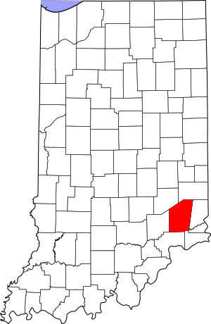
This is a list of the National Register of Historic Places listings in Ripley County, Indiana.
This is intended to be a complete list of the properties on the National Register of Historic Places in Ripley County, Indiana, United States. Latitude and longitude coordinates are provided for many National Register properties; these locations may be seen together in a map.
There are 16 properties listed on the National Register in the county.
Properties and districts located in incorporated areas display the name of the municipality, while properties and districts in unincorporated areas display the name of their civil township. Properties and districts split between multiple jurisdictions display the names of all jurisdictions.
Current listings
| Name on the Register | Image | Date listed | Location | City or town | Description | |
|---|---|---|---|---|---|---|
| 1 | Central Batesville Historic District |
(#11000659) |
Roughly bounded by Catherine, Vine, and Boehringer Sts., and Eastern Ave. 39°17′52″N 85°13′19″W / 39.297778°N 85.221944°W |
Batesville | ||
| 2 | Central House |
(#82000071) |
State Road 229 39°12′18″N 85°19′42″W / 39.205056°N 85.328333°W |
Napoleon | ||
| 3 | Collin's Ford Bridge |
(#96000787) |
Big Oaks National Wildlife Refuge, approximately 0.75 miles west of New Marion 39°00′29″N 85°22′14″W / 39.008056°N 85.370556°W |
Shelby Township | ||
| 4 | Elias Conwell House |
(#79000041) |
Wilson St. and U.S. Route 421 39°12′23″N 85°19′50″W / 39.206389°N 85.330556°W |
Napoleon | ||
| 5 | Marble Creek Bridge |
(#96000785) |
Big Oaks National Wildlife Refuge, approximately 0.75 miles west of the junction of G and W. Recovery Rds. 38°55′39″N 85°26′31″W / 38.9275°N 85.441944°W |
Shelby Township | ||
| 6 | Milan Masonic Lodge No. 31 |
(#12001155) |
312 Main St. 39°07′30″N 85°07′54″W / 39.125000°N 85.131667°W |
Milan | ||
| 7 | Old Timbers |
(#96000786) |
Big Oaks National Wildlife Refuge, approximately 0.5 miles southeast of the junction of K Rd. and Northeast Exit 39°00′17″N 85°23′26″W / 39.004722°N 85.390556°W |
Shelby Township | ||
| 8 | John Linsey Rand House |
(#94000582) |
Southwestern corner of the junction of State Road 62 and Maxine Moss Dr. at Friendship 38°57′57″N 85°08′43″W / 38.965833°N 85.145278°W |
Brown Township | ||
| 9 | Ripley County Courthouse |
(#09000762) |
115 N. Main St. 39°04′19″N 85°15′07″W / 39.071944°N 85.251944°W |
Versailles | ||
| 10 | Straber Ford Bridge |
(#09001132) |
County Road 500N over Otter Creek, northwest of Osgood 39°08′53″N 85°21′44″W / 39.147944°N 85.362222°W |
Center Township | ||
| 11 | Fernando G. Taylor House |
(#86002710) |
Northeastern corner of Main and Tyson Sts. 39°04′17″N 85°15′03″W / 39.071389°N 85.250833°W |
Versailles | ||
| 12 | Tyson United Methodist Church |
(#94001106) |
324 W. Tyson St. 39°04′19″N 85°15′14″W / 39.071944°N 85.253889°W |
Versailles | ||
| 13 | Versailles School and Tyson Auditorium |
(#06000309) |
100 S. High St. 39°04′18″N 85°15′20″W / 39.071667°N 85.255556°W |
Versailles |

All content from Kiddle encyclopedia articles (including the article images and facts) can be freely used under Attribution-ShareAlike license, unless stated otherwise. Cite this article:
National Register of Historic Places listings in Ripley County, Indiana Facts for Kids. Kiddle Encyclopedia.


