National Register of Historic Places listings in Madison County, Arkansas facts for kids
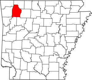
This is a list of the National Register of Historic Places listings in Madison County, Arkansas.
This is intended to be a complete list of the properties and districts on the National Register of Historic Places in Madison County, Arkansas, United States. The locations of National Register properties and districts for which the latitude and longitude coordinates are included below, may be seen in a map.
There are 11 properties and districts listed on the National Register in the county.
Current listings
| Name on the Register | Image | Date listed | Location | City or town | Description | |
|---|---|---|---|---|---|---|
| 1 | Bank of Kingston |
(#82002122) |
101 Public Sq. 36°03′03″N 93°31′05″W / 36.050814°N 93.518101°W |
Kingston | 1911 commercial structure | |
| 2 | Bunch Store |
(#99001350) |
100 Public Sq. 36°03′03″N 93°31′06″W / 36.050840°N 93.518336°W |
Kingston | 1890 wood frame commercial structure | |
| 3 | Cannon Creek Bridge |
(#04001033) |
County Road 5340 35°54′26″N 93°56′44″W / 35.907222°N 93.945556°W |
Cannon Creek | 1929 curved concrete deck bridge built on former Highway 16 | |
| 4 | Enterprise School |
(#92001192) |
Southeast of the junction of County Roads 8 and 192 35°59′17″N 93°55′27″W / 35.988056°N 93.924167°W |
Thorney | 1935 school with Craftsman and Colonial Revival details | |
| 5 | Huntsville Commercial Historic District |
(#08000705) |
Roughly bounded by War Eagle, Hughes, Church, and Harris Sts. 36°05′15″N 93°44′09″W / 36.0874°N 93.7358°W |
Huntsville | Historic center of economic activity in Huntsville | |
| 6 | Madison County Courthouse |
(#93001253) |
1 Main St. 36°05′14″N 93°44′11″W / 36.087222°N 93.736389°W |
Huntsville | 1939 restrained Art Deco structure | |
| 7 | Pettigrew School |
(#95000272) |
North of Highway 16 35°49′04″N 93°38′59″W / 35.817778°N 93.649722°W |
Pettigrew | 1915 wood frame school | |
| 8 | St. Paul School Building |
(#06000416) |
200 W. 4th St. 35°49′29″N 93°45′59″W / 35.824722°N 93.766389°W |
St. Paul | 1939 WPA school | |
| 9 | War Eagle Creek Bridge |
(#07001430) |
County Road 53 over War Eagle Creek 36°07′24″N 93°41′39″W / 36.123333°N 93.694167°W |
Old Alabam | 1925 open-spandrel concrete arch bridge | |
| 10 | Williams House and Associated Farmstead |
(#01000508) |
Off Highway 23 35°50′51″N 93°44′56″W / 35.8475°N 93.748889°W |
St. Paul | 1935 hand-hewn log cabin structure with 1922 outbuildings |
Former listing
| Name on the Register | Image | Date listed | Date removed | Location | City or town | Summary | |
|---|---|---|---|---|---|---|---|
| 1 | Alabam School |
(#76000432) |
|
S of Alabam at junction of U.S. Highway 412 and Highway 127 |
Old Alabam | 1925 church/school |

All content from Kiddle encyclopedia articles (including the article images and facts) can be freely used under Attribution-ShareAlike license, unless stated otherwise. Cite this article:
National Register of Historic Places listings in Madison County, Arkansas Facts for Kids. Kiddle Encyclopedia.


