Muret - Lherm Aerodrome facts for kids
Quick facts for kids
Muret - Lherm Aerodrome
Aérodrome de Muret-Lherm
|
|||||||||||||||
|---|---|---|---|---|---|---|---|---|---|---|---|---|---|---|---|
 |
|||||||||||||||
| Summary | |||||||||||||||
| Airport type | Public | ||||||||||||||
| Serves | Muret, France | ||||||||||||||
| Location | Lherm, France | ||||||||||||||
| Elevation AMSL | 622 ft / 189 m | ||||||||||||||
| Coordinates | 43°26′58.844″N 001°15′49.266″E / 43.44967889°N 1.26368500°E | ||||||||||||||
| Runway | |||||||||||||||
|
|||||||||||||||
|
Source: French AIP
|
|||||||||||||||
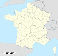
Muret - Lherm Aerodrome (ICAO code: LFBR) is located at Lherm in the Haute-Garonne département in the Occitanie region. It is 5 kilometres (3.1 mi) southwest of Muret.
A campus of the École nationale de l'aviation civile (French civil aviation university) is located on the aerodrome.
Specifications
- Airfield elevation : 189 meters
- Asphalt runway : 1 100 m × 30 m
- Grass runway : 825 m × 50 m
Air show

All content from Kiddle encyclopedia articles (including the article images and facts) can be freely used under Attribution-ShareAlike license, unless stated otherwise. Cite this article:
Muret - Lherm Aerodrome Facts for Kids. Kiddle Encyclopedia.

