Occitanie facts for kids
Quick facts for kids
Occitanie
Occitània
|
|||
|---|---|---|---|
|
|||
 |
|||
| Country | |||
| Prefecture | Toulouse | ||
| Departments |
13
Ariège (09)
Aude (11) Aveyron (12) Gard (30) Gers (32) Haute-Garonne (31) Hautes-Pyrénées (65) Hérault (34) Lot (46) Lozère (48) Pyrénées-Orientales (66) Tarn (81) Tarn-et-Garonne (82) |
||
| Area | |||
| • Total | 72,724 km2 (28,079 sq mi) | ||
| Population
(2015)
|
|||
| • Total | 5,774,185 | ||
| • Density | 79.3986/km2 (205.6415/sq mi) | ||
| Demonym(s) | Occitans | ||
| Time zone | UTC+1 (CET) | ||
| • Summer (DST) | UTC+2 (CEST) | ||
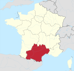
Occitanie (Occitan: Occitània, Catalan: Occitània) is an administrative region of France that was created on 1 January 2016 from the former French regions Languedoc-Roussillon and Midi-Pyrénées. Languedoc-Roussillon-Midi-Pyrénées was the temporary name for the region.
The name Occitania (French: Occitanie) was approved as the new name of the region on 28 September 2016, effective 30 September 2016.
The new Occitania Region should not be confused with the wider cultural entity of Occitania, of which the new administrative region is part.
Geography
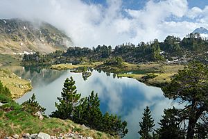
The Occitanie region is the third largest region of France, after Nouvelle-Aquitaine and French Guiana, and the second of Metropolitan France with an area of 72,723.5 km2 (28,079 sq mi). It is in southern France (the Midi) and borders to the south with Spain and Andorra; it also borders three French regions: Nouvelle-Aquitaine to the west, Auvergne-Rhône-Alpes to the north, Provence-Alpes-Côte d'Azur to the east. The Mediterranean Sea is to the southeast.
Its capital, Toulouse, is at 590 km (367 mi) to the southwest of Paris, the national capital, at 405 km (252 mi) to the west of Marseille, at 245 km (152 mi) fto the southeast of Bordeaux and at 395 km (245 mi) to the north of Barcelona (Spain).
Rivers
There are two main drainage basin in the region; some rivers in those basins are:
- Atlantic basin
- Mediterranean basin
Mountains
The Pic Vignemale (42°46′26″N 0°8′51″E / 42.77389°N 0.14750°E), at 3,299 m (10,823 ft), is the highest mountain of the Occitanie region; it is on the border with Spain. It is in the Pyrénées National Park.
The highest point of the different departments of the Occitanie region are:
| Department | Mountain | Elevation |
|---|---|---|
| Ariège | Pica d'Estats | 3,142 m (10,308 ft) |
| Aude | Pic de Madrès | 2,469 m (8,100 ft) |
| Aveyron | Signal de Mailhe-Biau | 1,463 m (4,800 ft) |
| Gard | Mont Aigoual | 1,565 m (5,135 ft) |
| Haute-Garonne | Perdiguero | 3,221 m (10,568 ft) |
| Gers | Mont de Chapelle Saint Roch | 377 m (1,237 ft) |
| Hérault | Valbonne | 1,151 m (3,776 ft) |
| Lot | Signal de Labastide-du-Haut-Mont | 783 m (2,569 ft) |
| Lozère | Mont Lozère | 1,699 m (5,574 ft) |
| Hautes-Pyrénées | Pic Vignemale | 3,299 m (10,823 ft) |
| Pyrénées-Orientales | Pic Carlit | 2,921 m (9,583 ft) |
| Tarn | Puech de Rascas | 1,270 m (4,170 ft) |
| Tarn-et-Garonne | Puech des Carts-Sommet Nord | 504 m (1,654 ft) |
Departments
The Occitanie region is formed by 13 departments:
| ISO 3166-2 |
Shield | Department | Prefecture | Arr. | Cant. | Comm. | Population (2013) |
Area (km²) |
Density (Inh./km²) |
|---|---|---|---|---|---|---|---|---|---|
| FR-09 | Ariège | Foix | 3 | 13 | 332 | 152,684 | 4,889.9 | 31.2 | |
| FR-11 | Aude | Carcassonne | 3 | 19 | 436 | 364,877 | 6,139.0 | 59.4 | |
| FR-12 | Aveyron | Rodez | 3 | 23 | 286 | 277,740 | 8,735.1 | 31.8 | |
| FR-30 | Gard | Nîmes | 3 | 23 | 353 | 733,201 | 5,852.8 | 125.3 | |
| FR-31 | Haute-Garonne | Toulouse | 3 | 27 | 589 | 1,298,562 | 6,309.3 | 205.8 | |
| FR-32 | Gers | Auch | 3 | 17 | 462 | 190,276 | 6,256.8 | 30.4 | |
| FR-34 | Hérault | Montpellier | 3 | 25 | 343 | 1,092,331 | 6,101.0 | 179.0 | |
| FR-46 | Lot | Cahors | 3 | 17 | 326 | 173,758 | 5,216.5 | 33.3 | |
| FR-48 | Lozère | Mende | 2 | 13 | 176 | 76,607 | 5,166.9 | 14.8 | |
| FR-65 | Hautes-Pyrénées | Tarbes | 3 | 17 | 472 | 228,868 | 4,464.0 | 51.3 | |
| FR-66 | Pyrénées-Orientales | Perpignan | 3 | 17 | 226 | 462,705 | 4,116.0 | 112.4 | |
| FR-81 | Tarn | Albi | 2 | 23 | 320 | 381,927 | 5,757.9 | 66.3 | |
| FR-82 | Tarn-et-Garonne | Montauban | 2 | 30 | 195 | 250,342 | 3,718.3 | 67.3 | |
| Total of the Region | 36 | 264 | 4,516 | 5,683,878 | 72,723.5 | 78.2 | |||
Arr. = Arrondissements Cant. = Cantons Comm. = Communes
Demographics
The Occitanie region had a population, in 2013, of 5,683,878, for a population density of 78.2 inhabitants/km2.
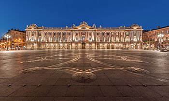
The important cities with more than 20,000 inhabitans (2013) in the region are:
| INSEE code |
City | Department | Population (2013) |
|---|---|---|---|
| 31555 | Toulouse | Haute-Garonne | 458,298 |
| 34172 | Montpellier | Hérault | 272,084 |
| 30189 | Nîmes | Gard | 150,564 |
| 66136 | Perpignan | Pyrénées-Orientales | 120,959 |
| 34032 | Béziers | Hérault | 74,811 |
| 82121 | Montauban | Tarn-et-Garonne | 57,921 |
| 11262 | Narbonne | Aude | 52,802 |
| 81004 | Albi | Tarn | 49,342 |
| 11069 | Carcassonne | Aude | 46,724 |
| 34301 | Sète | Hérault | 44,270 |
| 81065 | Castres | Tarn | 41,636 |
| 65440 | Tarbes | Hautes-Pyrénées | 41,062 |
| 30007 | Alès | Gard | 40,711 |
| 31149 | Colomiers | Haute-Garonne | 38,302 |
| 31557 | Tournefeuille | Haute-Garonne | 26,206 |
| 34003 | Agde | Hérault | 25,253 |
| 34145 | Lunel | Hérault | 25,006 |
| 31395 | Muret | Haute-Garonne | 24,725 |
| 12202 | Rodez | Aveyron | 23,741 |
| 31069 | Blagnac | Haute-Garonne | 22,969 |
| 34108 | Frontignan | Hérault | 22,942 |
| 12145 | Millau | Aveyron | 22,205 |
| 32013 | Auch | Gers | 21,962 |
Gallery
Related pages


