Montgomery County, Alabama facts for kids
Quick facts for kids
Montgomery County
|
||
|---|---|---|

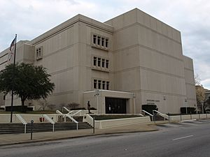
Montgomery County Courthouse in Montgomery
|
||
|
||

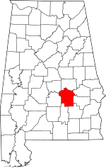
Location within the U.S. state of Alabama
|
||
 Alabama's location within the U.S. |
||
| Country | ||
| State | ||
| Founded | December 6, 1816 | |
| Named for | Lemuel P. Montgomery | |
| Seat | Montgomery | |
| Largest city | Montgomery | |
| Area | ||
| • Total | 800 sq mi (2,000 km2) | |
| • Land | 784 sq mi (2,030 km2) | |
| • Water | 16 sq mi (40 km2) 2.0% | |
| Population
(2020)
|
||
| • Total | 228,954 | |
| • Estimate
(2023)
|
224,980 |
|
| • Density | 286/sq mi (110/km2) | |
| Time zone | UTC−6 (Central) | |
| • Summer (DST) | UTC−5 (CDT) | |
| Congressional districts | 2nd, 7th | |
|
||
Montgomery County is a county located in the U.S. state of Alabama. As of the 2020 census, its population was 228,954, making it the seventh-most populous county in Alabama. Its county seat is Montgomery, the state capital. Montgomery County is included in the Montgomery Metropolitan Statistical Area.
Contents
History
Montgomery County was established by dividing Monroe County on December 6, 1816, by the Mississippi Territorial Legislature. It is named for Lemuel P. Montgomery, a young U.S. Army officer killed at the Battle of Horseshoe Bend, the final battle of the Creek Indian war, which was waged concurrently with the War of 1812.
The city of Montgomery, which is the county seat, is named for Richard Montgomery, an American Revolutionary War general killed in 1775 while attempting to capture Quebec City, Canada.
Over much of the 19th century great wealth was derived from the cotton crop, with the Civil War producing a temporary setback. More lasting trouble came in 1914 with the arrival of the boll weevil, which became very destructive to the cotton harvest from 1915 on. By the 1940s county farms earned more from cattle than cotton.
Geography
According to the United States Census Bureau, the county has a total area of 800 square miles (2,100 km2), of which 784 square miles (2,030 km2) is land and 16 square miles (41 km2) (2.0%) is water.
Major highways
Transit
- Montgomery Area Transit System
Adjacent counties
- Elmore County (north)
- Macon County (northeast)
- Bullock County (east)
- Pike County (southeast)
- Crenshaw County (southwest)
- Lowndes County (west)
- Autauga County (northwest)
National protected area
Demographics
| Historical population | |||
|---|---|---|---|
| Census | Pop. | %± | |
| 1820 | 6,604 | — | |
| 1830 | 12,695 | 92.2% | |
| 1840 | 24,574 | 93.6% | |
| 1850 | 29,711 | 20.9% | |
| 1860 | 35,904 | 20.8% | |
| 1870 | 43,704 | 21.7% | |
| 1880 | 52,356 | 19.8% | |
| 1890 | 56,172 | 7.3% | |
| 1900 | 72,047 | 28.3% | |
| 1910 | 82,178 | 14.1% | |
| 1920 | 80,853 | −1.6% | |
| 1930 | 98,671 | 22.0% | |
| 1940 | 114,420 | 16.0% | |
| 1950 | 138,965 | 21.5% | |
| 1960 | 169,210 | 21.8% | |
| 1970 | 167,790 | −0.8% | |
| 1980 | 197,038 | 17.4% | |
| 1990 | 209,085 | 6.1% | |
| 2000 | 223,510 | 6.9% | |
| 2010 | 229,363 | 2.6% | |
| 2020 | 228,954 | −0.2% | |
| 2023 (est.) | 224,980 | −1.9% | |
| U.S. Decennial Census 1790–1960 1900–1990 1990–2000 2010–2020 |
|||
2020 Census
| Race / Ethnicity (NH = Non-Hispanic) | Pop 2000 | Pop 2010 | Pop 2020 | % 2000 | % 2010 | % 2020 |
|---|---|---|---|---|---|---|
| White alone (NH) | 107,858 | 88,099 | 73,354 | 48.26% | 38.41% | 32.04% |
| Black or African American alone (NH) | 108,146 | 124,928 | 129,801 | 48.39% | 54.47% | 56.69% |
| Native American or Alaska Native alone (NH) | 530 | 520 | 364 | 0.24% | 0.23% | 0.16% |
| Asian alone (NH) | 2,189 | 4,792 | 7,952 | 0.98% | 2.09% | 3.47% |
| Pacific Islander alone (NH) | 67 | 84 | 119 | 0.03% | 0.04% | 0.05% |
| Other race alone (NH) | 178 | 187 | 722 | 0.08% | 0.08% | 0.32% |
| Mixed race or Multiracial (NH) | 1,877 | 2,439 | 5,958 | 0.84% | 1.06% | 2.60% |
| Hispanic or Latino (any race) | 2,665 | 8,314 | 10,684 | 1.19% | 3.62% | 4.67% |
| Total | 223,510 | 229,363 | 228,954 | 100.00% | 100.00% | 100.00% |
As of the 2020 census, there were 228,954 people, 93,223 households, and 56,961 families residing in the county. The population density was 291.5 inhabitants per square mile (112.5/km2) There were 105,293 housing units.
2010 census
The 2010 census reported the following county population:
- 54.7% Black
- 39.5% White
- 3.6% Hispanic or Latino (of any race)
- 1.3% Two or more races
- 1.2% Asian
- 0.3% Native American
- 0.0% Native Hawaiian or Pacific Islander
Education

Montgomery Public Schools operates public schools serving most of the county. However, Pike Road City School District operates public schools in Pike Road. Additionally Maxwell Air Force Base is zoned to Department of Defense Education Activity (DoDEA) schools. The DoDEA operates Maxwell Air Force Base Elementary/Middle School. For high school Maxwell AFB residents are zoned to Montgomery Public Schools facilities.
The Montgomery City-County Public Library operates public libraries.
Universities/Colleges include:
- Huntingdon College
- Faulkner University
- Alabama State University
- Auburn University Montgomery
- Virginia College
- Amridge University
- H. Council Trenholm Tech
- United States Air War College
- Troy University Montgomery
Cultural sites
Montgomery County is home to many cultural and historic sites including:
- Alabama Shakespeare Festival
- Montgomery Museum of Fine Arts
- Montgomery Zoo
- Dexter Avenue Baptist Church
- Museum of Alabama (Alabama Department of Archives and History)
- Alabama State Capitol
- W. A. Gayle Planetarium
- Civil Rights Memorial
- First White House of the Confederacy
- Zelda and F. Scott Fitzgerald Museum
- Old Montgomery Greyhound Bus Station (Freedom Rides Museum)
- Rosa Parks Library and Museum
Communities
City
- Montgomery (county seat and largest municipality)
Town
Unincorporated communities
See also
 In Spanish: Condado de Montgomery (Alabama) para niños


