Bullock County, Alabama facts for kids
Quick facts for kids
Bullock County
|
|||
|---|---|---|---|

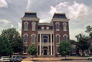
Bullock County courthouse in Union Springs
|
|||
|
|||

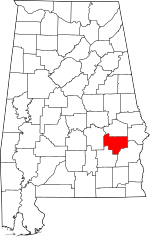
Location within the U.S. state of Alabama
|
|||
 Alabama's location within the U.S. |
|||
| Country | |||
| State | |||
| Founded | December 5 (created), 1866 | ||
| Named for | Edward Bullock | ||
| Seat | Union Springs | ||
| Largest city | Union Springs | ||
| Area | |||
| • Total | 625 sq mi (1,620 km2) | ||
| • Land | 623 sq mi (1,610 km2) | ||
| • Water | 2.3 sq mi (6 km2) 0.4% | ||
| Population
(2020)
|
|||
| • Total | 10,357 | ||
| • Estimate
(2023)
|
9,897 |
||
| • Density | 16.571/sq mi (6.398/km2) | ||
| Time zone | UTC−6 (Central) | ||
| • Summer (DST) | UTC−5 (CDT) | ||
| Congressional district | 2nd | ||
|
|||
Bullock County is a county of the U.S. state of Alabama. As of the 2020 census, the population was 10,357. Union Springs was chosen as the county seat in 1867, and presently is the county's only incorporated city. The county was named for Confederate Army Colonel Edward C. Bullock who was a state senator and outspoken secessionist who died during the American Civil War.
A National Center for Education Statistics report released in January 2009 showed that Bullock County had the highest illiteracy rate in Alabama at 34 percent.
Contents
History
Bullock County was established on December 5, 1866. The boundaries were changed in February 1867.
Geography
According to the U.S. Census Bureau, the county has a total area of 625 square miles (1,620 km2), of which 623 square miles (1,610 km2) is land and 2.3 square miles (6.0 km2) (0.4%) is water. The county is in the southeastern section of the state, in the prairie region. The Chunnennuggee Ridge runs through the center of the county.
Adjacent counties
- Macon County (north)
- Russell County (northeast)
- Barbour County (southeast)
- Pike County (southwest)
- Montgomery County (west)
Communities
City
- Union Springs (county seat)
Town
Census-designated place
Other unincorporated communities
Ghost town
Demographics
| Historical population | |||
|---|---|---|---|
| Census | Pop. | %± | |
| 1870 | 24,474 | — | |
| 1880 | 29,066 | 18.8% | |
| 1890 | 27,063 | −6.9% | |
| 1900 | 31,944 | 18.0% | |
| 1910 | 30,196 | −5.5% | |
| 1920 | 25,333 | −16.1% | |
| 1930 | 20,016 | −21.0% | |
| 1940 | 19,810 | −1.0% | |
| 1950 | 16,054 | −19.0% | |
| 1960 | 13,462 | −16.1% | |
| 1970 | 11,824 | −12.2% | |
| 1980 | 10,596 | −10.4% | |
| 1990 | 11,042 | 4.2% | |
| 2000 | 11,714 | 6.1% | |
| 2010 | 10,914 | −6.8% | |
| 2020 | 10,357 | −5.1% | |
| 2023 (est.) | 9,897 | −9.3% | |
| U.S. Decennial Census 1790–1960 1900–1990 1990–2000 2010–2020 |
|||
2020 census
| Race | Num. | Perc. |
|---|---|---|
| White (non-Hispanic) | 2,281 | 22.02% |
| Black or African American (non-Hispanic) | 7,388 | 71.33% |
| Native American | 1 | 0.01% |
| Asian | 9 | 0.09% |
| Pacific Islander | 7 | 0.07% |
| Other/Mixed | 168 | 1.62% |
| Hispanic or Latino | 503 | 4.86% |
As of the 2020 United States census, there were 10,357 people, 3,521 households, and 2,504 families residing in the county.
2010 census
As of the 2010 United States census, there were 10,914 people in the county. 70.2% were Black or African American, 23.0% White, 0.4% Pacific Islander, 0.2% Native American, 0.2% Asian, 5.2% of some other race and 0.8% of two or more races. 7.1% were Hispanic or Latino (of any race).
Education
Bullock County contains one public school district. There are approximately 1,400 students in public PK-12 schools in Bullock County.
Districts
School districts include:
- Bullock County School District
Climate
|
||||||||||||||||||||||||||||||||||||||||||||||||||||||||||||||||||||||||||||||||||||||||||||||||
See also
 In Spanish: Condado de Bullock para niños


