Mill Basin, Brooklyn facts for kids
Quick facts for kids
Mill Basin
|
|
|---|---|
|
Neighborhood of Brooklyn
|
|
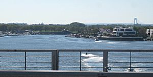
The neighborhood and waterway of Mill Basin, seen from the Belt Parkway drawbridge
|
|
| Etymology: A grist mill built by Dutch settlers in the 17th century | |
| Country | |
| State | |
| City | |
| Borough | Brooklyn |
| Community District | Brooklyn 18 |
| Population
(2010)
|
|
| • Total | 45,231 |
| Neighborhood tabulation area; includes Mill Basin, Bergen Beach, Marine Park, and Flatlands | |
| Ethnicity | |
| • White | 73.8% |
| • Black | 10.9% |
| • Hispanic | 7.9% |
| • Asian | 5.6% |
| • Other | 1.8% |
| ZIP Code |
11234
|
| Area codes | 718, 347, 929, and 917 |
Mill Basin is a residential neighborhood in southeastern Brooklyn, New York City. It is on a peninsula abutting Jamaica Bay and is bordered by Avenue U on the northwest and the Mill Basin/Mill Island Inlet on its remaining sides. Mill Basin is adjacent to the neighborhood of Bergen Beach to the northeast, Flatlands to the northwest, Marine Park to the southwest, and Floyd Bennett Field and the former Barren Island to the southeast. Mill Basin also contains a subsection called Old Mill Basin, north of Avenue U.
Mill Basin was originally Mill Island, in Jamaica Bay. In the 17th century, a mill was built on Mill, Bergen, and Barren Islands. The archipelago was then occupied by the Schenck and Crooke families through the late 19th century, and remained a mostly rural area with oyster fishing. After Robert Crooke developed a smelting plant on Mill Island in 1890, industrial customers started developing the island and connected it to the rest of Brooklyn. In an effort to develop Mill Basin as a seaport district, ports and dry docks were built in the early 20th century, though a lack of railroad connections hindered the area's further growth. Residential development began in the 1950s, along with much of the rest of southeast Brooklyn, though some of the former industrial buildings remain.
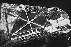
Mill Basin has some of the most luxurious houses in New York City, though it also contains commercial and industrial tenants, as well as the Kings Plaza shopping mall in its western part. The area around Mill Basin consists of a mostly white population as of the 2010 United States Census, and is sparsely served by public transportation. Nearby recreational areas include Floyd Bennett Field, the first municipal airport in New York City, which is part of the Gateway National Recreation Area and is just southeast of Mill Basin.
Mill Basin is part of Brooklyn Community District 18, and its primary ZIP Code is 11234. It is patrolled by the 63rd Precinct of the New York City Police Department.
Contents
Geography
Originally, Mill Basin was an island in Jamaica Bay off the coast of Canarsie, called Mill Island. Most of the island was composed of low-lying meadows near sea level, but a very small part of it was arable uplands, or hilly areas above sea level. The area's original geography was vastly different from the modern geography.
A bulkhead was built along Mill Island's shore in the late 1890s. It was later connected to the uplands of nearby Bergen Beach, creating the continuous embankment between Mill and Paerdegat basins later used for the construction of the Belt Parkway. Most of the earliest filling operations along the island were private; the city government took over later. Some parts of Mill Basin remained a wetland until the late 20th century. A stream ran where Avenue U is today, dividing Mill Island from the mainland. Maps show that Mill Island was connected to the mainland by 1926, but modern city maps still allude to "Mill Island".
The New York Times described the neighborhood as a "mitten-shaped peninsula" enclosed to the south, west, and east by the eponymous waterway. Mill Basin is zoned as a predominantly residential neighborhood with one- or two-family residences. Small commercial overlays and recreational waterfront uses also exist, and the area between Avenue U and the Mill Basin waterway is zoned for heavy industry. Old Mill Basin is north of Avenue U. According to a map The New York Times published in 2009, Old Mill Basin can be considered to reach as far north as Avenue N.
History
Early settlement
The local Lenape Native Americans originally inhabited the area. They referred to the surrounding area, including Mill and Barren Islands, as "Equendito" or "Equindito", a name that probably means "Broken Lands". In 1624, the Dutch Republic incorporated much of the current New York City area into the colony of New Netherland. In 1636, as Dutch settlers expanded outward from present-day Manhattan, they founded the town of Achtervelt (later Amersfoort, then Flatlands) and purchased 15,000 acres (6,100 ha) around Jamaica Bay. Amersfoort was centered around the present-day intersection of Flatbush Avenue and Flatlands Avenue. Canarsie Indian leaders signed three land agreements with Dutch settlers between 1636 and 1667, ceding much of their historic land, including Mill Island. Mill Island, as well as the nearby Barren Island, was sold to John Tilton Jr. and Samuel Spicer in 1664. At some point in the 1660s or 1670s, a settler named Elbert Elbertse leased Mill Island, along with Bergen and Barren Islands.
The land was owned from 1675 by Jans Martense Schenck, who built a house on the land believed to be one of the oldest houses in New York City. Schenck also built a pier so he could load and unload cargo to or from the Netherlands. A tide mill had been built on the land by that time, but the exact date of the mill's construction is not known; sources give dates between 1660 and 1675. One of Schenck's relatives, a ship captain named Hendrick, allegedly formed an alliance with the pirate William Kidd and allowed Kidd to bury treasure on Mill Island.
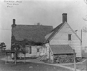
When Schenck died in 1689, his son Martin received ownership of the estate; the mill was later inherited by Nicholas Schenck. In 1784, the property was sold to Joris Martense of Flatbush. Martense also received "66 acres [27 ha] of uplands, 6 acres [2.4 ha] of woodlands, and a parcel of salt-meadows" in the transaction, as noted in a 1909 history of Brooklyn. By 1794, John Schenck was renting the property from Joris's widow. At the time, the mill was called "the mill of Martensen".
The property, which included the mill, farm, and house, was later conveyed to Susan Caton, the daughter of Joris Martense. Caton named Robert L. Crooke as the trustee for Caton's daughter, Margaret Crooke, who was married to General Philip S. Crooke. In 1818, Margaret Crooke inherited the land. After this conveyance, the mill was called "Crooke's Mill". General Crooke was the trustee for the Crooke children, and upon Margaret's death, had the power to pass the property down to their children. In 1870, after Margaret died, he conveyed the property to Robert, who gave the property back in 1873. Over the next 30 years, there were a dozen more land conveyances, and by 1906, Robert Crooke owned the property again.
The name "Mill Island" is believed to have been first used in the late 19th century. Before then, settlers called it "the mill" because of the gristmill there.
Community
The New York Times has characterized Mill Basin as a suburban community with a nearly-360-degree shoreline. It is adjoined by the waterway of the same name to the south and west. Many residents own boats. Mill Basin is part of Brooklyn Community Board 18, which also includes Canarsie, Bergen Beach, Georgetown, Marine Park, and the southern portion of Flatlands.
The neighborhood has evolved to include some of New York City's most luxurious houses. Most of the housing stock was developed in the late 20th century, and many waterfront houses include docks, water views, or high ceilings. Prices of houses often range in the millions. As of 2017[update], an unrenovated house on a 40-by-100-foot (12 by 30 m) lot along a main street had a minimum price around $850,000. Housing prices rose based on the width of the lot, extent of renovations, and proximity to the water: the cheapest waterfront house is $1.6 million. A few houses also had elevators, and several had features such as six-car garages and all-glass facades.
In Georgetown, north of Mill Basin, there are two-family brick townhouses with overhanging balconies and awnings. Old Mill Basin, to the northeast, mostly has detached frame houses. It is defined as the portion of the neighborhood north of Avenue U. In Mill Island, the peninsular part of Mill Basin, houses are more expensive than in the rest of the neighborhood; the cheapest houses are in the northwest corner. The former Mill Island and Old Mill Basin are divided by Avenue U, at the Mill Basin waterway's innermost reaches.
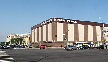
Some lead factories, built in the 20th century by Dutch businessmen, remain standing, but many are derelict. Commercial activities, mainly family-owned shops and restaurants, are primarily along Strickland Avenue and Avenue U. The Kings Plaza shopping mall, on a 23-acre (9.3 ha) plot at Avenue U and Flatbush Avenue, is Brooklyn's largest indoor shopping center. The neighborhood also contains Mill Plaza Mall, a strip mall at the northwest corner of Mill and Strickland Avenues.
Demographics
From the 1950s through the 1980s, the area was mainly Italian, but the predominant communities today are Russian and Israeli. By the end of the 20th century, the vast majority of Mill Basin residents were white, as were most residents of adjacent neighborhoods such as Bergen Beach and Marine Park. The 1990 United States Census counted 10 African-Americans living in Mill Basin; by the 2000 United States Census, there were 26. By 2011, the number of black residents in Southeast Brooklyn had risen 241%, the steepest such increase of any area in the city. As of that year, the African American population in these neighborhoods represented 10.9% of the total population.
Mill Basin is in ZIP Code 11234, which also includes Georgetown, Marine Park, Bergen Beach, and the southern portion of Flatlands. Based on data from the 2010 United States Census, the combined population of Georgetown, Marine Park, Bergen Beach, and Mill Basin was 45,231, an increase of 2,291 (5.3%) from the 42,940 counted in the 2000 United States Census. Covering an area of 1,662.88 acres (672.94 ha), the neighborhood had a population density of 27.2 inhabitants per acre (17,400/sq mi; 6,700/km2).
As of the 2010 Census, the racial makeup of Southeast Brooklyn was 73.8% (33,399) White, 10.9% (4,952) African American, 0.1% (47) Native American, 5.6% (2,521) Asian, 0.0% (7) Pacific Islander, 0.3% (144) from other races, and 1.3% (578) from two or more races. Hispanic or Latino of any race were 7.9% (3,583) of the population.
Recreation
There are several parks in Mill Basin. The only park on the peninsula proper is Lindower Park, a 6.7-acre (2.7 ha) park at the southwest corner of Mill and Strickland Avenues. The park is named after Alex Lindower, a lawyer and community activist who lived in Mill Basin. The city bought the land in 1959 and made it into a public park in 1963, the year before Lindower died. It contains baseball fields, basketball and handball courts, and a children's playground.
There are two smaller parks in Old Mill Basin. The James Marshall Power Playground, at Avenue N and Utica Avenue, is a frequent gathering point for softball teams. The Monsignor Crawford Athletic Field, on Avenue U between East 58th and East 60th Streets, contains two baseball fields. It is named after Monsignor Thomas J. Crawford, the first pastor of the Mary Queen of Heaven Church, four blocks north of the ballfields. Mill Basin is also adjacent to Floyd Bennett Field, to the immediate south of Mill Basin, across the Belt Parkway and Mill Basin Inlet. Named after aviator Floyd Bennett, the field was formerly the city's first municipal airport, and is now part of the Gateway National Recreation Area.
The bowler Lou Seda purchased the Gil Hodges Lanes, a bowling alley in Mill Basin, in 2009. It was then rebranded into a new bowling alley called Strike 10 Lanes, which as of 2012[update] was one of Brooklyn's few remaining bowling alleys.
Education
The New York City Department of Education operates several schools in the neighborhood, including P.S. 312, P.S. 236, and P.S. 203, all of which have historically ranked among the city's top public schools.
There are several private schools around Mill Basin, such as the Yeshivah of Crown Heights, the Mary Queen of Catholic Academy and St. Bernard Catholic Academy. The Roman Catholic Archdiocese of Brooklyn operates Catholic schools in that borough. Mary Queen of Heaven Catholic Academy was in the Mill Basin area, but closed in 2019 after falling into debt. The Canarsie Courier stated that St. Bernard was the closest remaining Catholic school.
Brooklyn Public Library operates the Mill Basin Library at 2385 Ralph Avenue, near Avenue N. The Mill Basin Library first opened in 1940, and it has been in its current building since 1975.
Transportation
Mill Basin is served by the B3, B41, B47, B100, Q35 and BM1 bus routes, operated by MTA Regional Bus Operations. There are no New York City Subway stations in the neighborhood; the closest stop is Kings Highway in Midwood, along the B and Q train. BM1 express bus service to Manhattan started in 1973, mainly as a result of the area's isolation from the subway.
Mill Basin Bridge
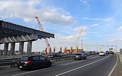
The original Mill Basin Bridge was a double-leaf bascule bridge supporting the Belt Parkway over Mill Basin. The span formerly carried six lanes of traffic, three in each direction, but as of September 2017[update], only the eastbound lanes use the drawbridge. There was a sidewalk on each side of the leaf; the eastern or downstream one, the only one still extant, is part of the Shore Parkway Greenway. Construction of the span was approved in 1939, and the bridge opened in 1940. It is the only drawbridge on the Belt Parkway. The New York City Department of Transportation renovated the Belt Parkway Bridge over Mill Basin in late 2006 because of severe deterioration, but began planning for a replacement span.
In 2013, the city proposed a 60-foot (18 m)-high fixed bridge to replace the aging span. The new bridge will also feature shoulders and wider lanes, which the drawbridge did not have. The new bridge started construction in 2015, with an expected completion date of 2021, four years after its original completion date of 2017. The westbound lanes were shifted to the newer bridge in August 2017.
Religion
There are several houses of worship in Mill Basin, including ten synagogues. Some of these have been converted from residential structures.
Images for kids


