New Netherland facts for kids
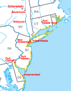
New Netherland (Dutch: Nieuw-Nederland, Latin: Nova Belgica or Novum Belgium) was a colony of the Dutch Empire from 1614 through 1664 and from 1673 through 1674. It was a base for the fur trade. The capital was New Amsterdam, modern-day New York City. The other important trading post in New Netherland was Fort Orange, now called Albany, New York. Most settlers lived in these towns or between them, along the Hudson River but some lived in distant parts of the colony.
During the Anglo-Dutch Wars England conquered New Netherland and divided it to make the English colonies of New York and New Jersey. The English also gave parts of it to Massachusetts, Rhode Island, Connecticut, Pennsylvania, Delaware and Maryland.
Images for kids
-
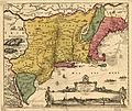
Map based on Adriaen Block's 1614 expedition to New Netherland, featuring the first use of the name. It was created by Dutch cartographers in the Golden Age of Dutch exploration (ca. 1590s–1720s) and Netherlandish cartography (ca. 1570s–1670s).
-
Map of New Netherland and New England, with north to the right
-
The West India House in Amsterdam, headquarters of the Dutch West India Company from 1623 to 1647
-
The storehouse of the Dutch West India Company in Amsterdam, built in 1642, became the headquarters of the board in 1647 because of financial difficulties after the loss of Dutch Brazil.
-
St. Mark's Church in-the-Bowery, site of Peter Stuyvesant's grave
-
Nicolaes Visscher I (1618–1679), Novi Belgii Novæque Angliæ, reprint of 1685 which is not a completely correct representation of the situation at the time. The border with New England had been adjusted to 50 miles (80 km) west of the Fresh River, while the Lange Eylandt towns west of Oyster Bay were under Dutch jurisdiction.
-
The original settlement has grown into the largest metropolis in the United States, seen here in 2006
-
The Noort Rivier was one of the three main rivers in New Netherland.
See also
 In Spanish: Nuevos Países Bajos para niños


