Metro Detroit facts for kids
Quick facts for kids
Metro Detroit
Detroit metropolitan area
|
|
|---|---|

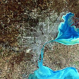
A simulated-color satellite image of Metro Detroit, with Windsor across the river, taken on NASA's Landsat 7 satellite.
|
|
| Country | |
| State | |
| Principal city | |
| Counties | |
| Area | |
| • Urban | 1,337.1 sq mi (3,463 km2) |
| • MSA | 3,888.4 sq mi (10,071 km2) |
| • CSA | 5,814 sq mi (15,060 km2) |
| Elevation | 569–1,280 ft (173–390 m) |
| Population
(2010)
|
|
| • Urban | 3,734,090 (11th) |
| • Urban density | 2,792.5/sq mi (1,078.2/km2) |
| • Metro density | 1,104.8/sq mi (426.6/km2) |
| • MSA | 4,296,250 (13th) |
| • CSA | 5,318,744 (12th) |
| Time zone | UTC−5 (EST) |
| • Summer (DST) | UTC−4 (EDT) |
| Area code(s) | 248, 313, 586, 734, 810, 947 |
The Detroit metropolitan area, often referred to as Metro Detroit, is a major metropolitan area in the U.S. State of Michigan, consisting of the city of Detroit and its surrounding area.
The area covers parts of the counties of Macomb, Oakland, and Wayne.
Images for kids
-
The Detroit Financial District viewed from the Detroit River
-
Merchants Row on Woodward Avenue between Grand Circus Park and Campus Martius Park in downtown Detroit
-
Downtown Howell
-
The General Motors World Headquarters, Renaissance Center in Downtown Detroit.
-
The Chrysler Headquarters in Auburn Hills
-
The Wildlife Interpretive Gallery at the Detroit Zoo
-
Henry Ford's Fair Lane estate in Dearborn
-
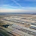
Detroit Metropolitan Airport, one of the largest air traffic hubs in the US.
-
View of the Ambassador Bridge
See also
 In Spanish: Metro Detroit para niños


