Detroit River facts for kids
Quick facts for kids Detroit River |
|
| Rivière du Détroit | |
|
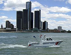
Windsor police passing by the Renaissance Center
|
|
| Countries | United States, Canada |
|---|---|
| State | Michigan |
| Province | Ontario |
| Tributaries | |
| - left | Ecorse River, River Rouge |
| - right | Little River, River Canard |
| Cities | United States: Detroit, Grosse Pointe Park, River Rouge, Ecorse, Wyandotte, Riverview, Trenton, Grosse Ile, Gibraltar, Canada: Tecumseh, Windsor, La Salle, Amherstburg |
| Source | Lake St. Clair |
| - elevation | 574 ft (175 m) |
| - coordinates | 42°21′07″N 82°55′03″W / 42.35194°N 82.91750°W |
| Mouth | Lake Erie |
| - elevation | 571 ft (174 m) |
| - coordinates | 42°03′06″N 83°09′05″W / 42.05167°N 83.15139°W |
| Length | 28 mi (45 km) |
| Basin | 700 sq mi (1,813 km²) |
| Discharge | |
| - average | 188,000 cu ft/s (5,324 m³/s) |
The Detroit River is a river in the Great Lakes system. The river connects Lake St. Clair to Lake Erie. It forms part of the border between Canada and the United States. It is 24 nautical miles (44 km; 28 mi) long. It divides the cities of Detroit and Windsor. It is one of the busiest waterways in the world.
The name comes from the French Rivière du Détroit, which means River of the Strait.
Images for kids
-
Satellite photo showing Lake Saint Clair (center) with the Detroit River connecting it to Lake Erie (to the south) and the St. Clair River connecting it to Lake Huron (to the north).
-
Aerial view of a classification yard and two train ferries, 1943
See also
 In Spanish: Río Detroit para niños

All content from Kiddle encyclopedia articles (including the article images and facts) can be freely used under Attribution-ShareAlike license, unless stated otherwise. Cite this article:
Detroit River Facts for Kids. Kiddle Encyclopedia.


