Marion County, Iowa facts for kids
Quick facts for kids
Marion County
|
|
|---|---|

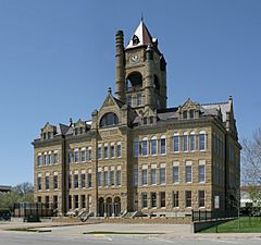
Marion County Courthouse in Knoxville
|
|

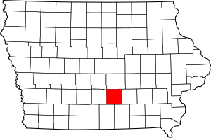
Location within the U.S. state of Iowa
|
|
 Iowa's location within the U.S. |
|
| Country | |
| State | |
| Founded | 1845 |
| Named for | Francis Marion |
| Seat | Knoxville |
| Largest city | Pella |
| Area | |
| • Total | 571 sq mi (1,480 km2) |
| • Land | 555 sq mi (1,440 km2) |
| • Water | 16 sq mi (40 km2) 2.8% |
| Population
(2020)
|
|
| • Total | 33,414 |
| • Estimate
(2023)
|
33,770 |
| • Density | 58.52/sq mi (22.594/km2) |
| Time zone | UTC−6 (Central) |
| • Summer (DST) | UTC−5 (CDT) |
| Congressional district | 2nd |
Marion County is a county in the U.S. state of Iowa. As of the 2020 census, the population was 33,414. The county seat is Knoxville. It is named for Francis Marion, a brigadier general from South Carolina in the American Revolutionary War.
Contents
Geography
According to the U.S. Census Bureau, the county has a total area of 571 square miles (1,480 km2), of which 555 square miles (1,440 km2) is land and 16 square miles (41 km2) (2.8%) is water.
Major highways
Adjacent counties
- Jasper County (north)
- Mahaska County (east)
- Monroe County (southeast)
- Lucas County (southwest)
- Warren County (west)
Demographics
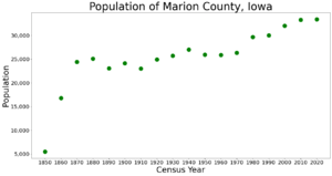
| Historical population | |||
|---|---|---|---|
| Census | Pop. | %± | |
| 1850 | 5,482 | — | |
| 1860 | 16,813 | 206.7% | |
| 1870 | 24,436 | 45.3% | |
| 1880 | 25,111 | 2.8% | |
| 1890 | 23,058 | −8.2% | |
| 1900 | 24,159 | 4.8% | |
| 1910 | 22,995 | −4.8% | |
| 1920 | 24,957 | 8.5% | |
| 1930 | 25,727 | 3.1% | |
| 1940 | 27,019 | 5.0% | |
| 1950 | 25,930 | −4.0% | |
| 1960 | 25,886 | −0.2% | |
| 1970 | 26,352 | 1.8% | |
| 1980 | 29,669 | 12.6% | |
| 1990 | 30,001 | 1.1% | |
| 2000 | 32,052 | 6.8% | |
| 2010 | 33,309 | 3.9% | |
| 2020 | 33,414 | 0.3% | |
| 2023 (est.) | 33,770 | 1.4% | |
| U.S. Decennial Census 1790-1960 1900-1990 1990-2000 2010-2018 |
|||
2020 census

The 2020 census recorded a population of 33,414 in the county, with a population density of 58.4743/sq mi (22.5771/km2). 96.24% of the population reported being of one race. 91.15% were non-Hispanic White, 0.87% were Black, 2.09% were Hispanic, 0.21% were Native American, 1.20% were Asian, 0.06% were Native Hawaiian or Pacific Islander and 4.41% were some other race or more than one race. There were 14,073 housing units, of which 13,145 were occupied.
2010 census
The 2010 census recorded a population of 33,309 in the county, with a population density of 60.1018/sq mi (23.2054/km2). There were 13,914 housing units, of which 12,723 were occupied.
Communities
Cities
Unincorporated communities
Townships
- Clay
- Dallas
- Franklin
- Indiana
- Knoxville
- Lake Prairie
- Liberty
- Pleasant Grove
- Red Rock
- Summit
- Union
- Washington
Population ranking
The population ranking of the following table is based on the 2020 census of Marion County.
† county seat
| Rank | City/Town/etc. | Municipal type | Population (2020 Census) |
|---|---|---|---|
| 1 | Pella | City | 10,464 |
| 2 | † Knoxville | City | 7,595 |
| 3 | Pleasantville | City | 1,676 |
| 4 | Melcher-Dallas | City | 1,195 |
| 5 | Bussey | City | 387 |
| 6 | Harvey | City | 236 |
| 7 | Hamilton | City | 119 |
| 8 | Swan | City | 76 |
| 9 | Marysville | City | 44 |
Gallery
-
Farm house and barn yard near Pleasantville, 1957
See also
 In Spanish: Condado de Marion (Iowa) para niños


