Lucas County, Iowa facts for kids
Quick facts for kids
Lucas County
|
|
|---|---|

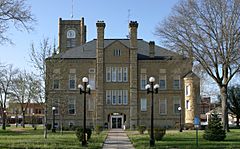
Lucas County Courthouse in Chariton
|
|

Location within the U.S. state of Iowa
|
|
 Iowa's location within the U.S. |
|
| Country | |
| State | |
| Founded | 1846 |
| Named for | Robert Lucas |
| Seat | Chariton |
| Largest city | Chariton |
| Area | |
| • Total | 434 sq mi (1,120 km2) |
| • Land | 431 sq mi (1,120 km2) |
| • Water | 3.8 sq mi (10 km2) 0.9% |
| Population
(2020)
|
|
| • Total | 8,634 |
| • Estimate
(2023)
|
8,747 |
| • Density | 19.894/sq mi (7.681/km2) |
| Time zone | UTC−6 (Central) |
| • Summer (DST) | UTC−5 (CDT) |
| Congressional district | 2nd |
Lucas County is a county located in the U.S. state of Iowa. As of the 2020 census, the population was 8,634. The county seat is Chariton. The county was formed in 1846 and was named for Robert Lucas, a Governor of the Territory.
Contents
Geography
According to the U.S. Census Bureau, the county has a total area of 434 square miles (1,120 km2), of which 431 square miles (1,120 km2) is land and 3.8 square miles (9.8 km2) (0.9%) is water.
Major highways
Adjacent counties
- Warren County (northwest)
- Marion County (northeast)
- Monroe County (east)
- Wayne County (south)
- Clarke County (west)
Demographics
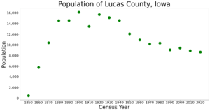
| Historical population | |||
|---|---|---|---|
| Census | Pop. | %± | |
| 1850 | 471 | — | |
| 1860 | 5,766 | 1,124.2% | |
| 1870 | 10,388 | 80.2% | |
| 1880 | 14,530 | 39.9% | |
| 1890 | 14,563 | 0.2% | |
| 1900 | 16,126 | 10.7% | |
| 1910 | 13,462 | −16.5% | |
| 1920 | 15,686 | 16.5% | |
| 1930 | 15,114 | −3.6% | |
| 1940 | 14,571 | −3.6% | |
| 1950 | 12,069 | −17.2% | |
| 1960 | 10,923 | −9.5% | |
| 1970 | 10,163 | −7.0% | |
| 1980 | 10,313 | 1.5% | |
| 1990 | 9,070 | −12.1% | |
| 2000 | 9,422 | 3.9% | |
| 2010 | 8,898 | −5.6% | |
| 2020 | 8,634 | −3.0% | |
| 2023 (est.) | 8,747 | −1.7% | |
| U.S. Decennial Census 1790-1960 1900-1990 1990-2000 2010-2018 |
|||
2020 census

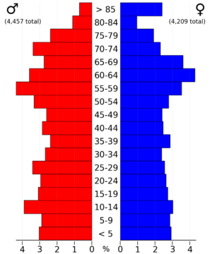
The 2020 census recorded a population of 8,634 in the county, with a population density of 19.9660/sq mi (7.7089/km2). 96.75% of the population reported being of one race. 92.76% were non-Hispanic White, 0.27% were Black, 2.29% were Hispanic, 0.08% were Native American, 0.34% were Asian, 0.00% were Native Hawaiian or Pacific Islander and 4.26% were some other race or more than one race. There were 4,058 housing units, of which 3,608 were occupied.
2010 census
The 2010 census recorded a population of 8,898 in the county, with a population density of 20.6666/sq mi (7.9794/km2). There were 4,238 housing units, of which 3,689 were occupied.
Communities
Cities
Townships
- Benton
- Cedar
- English
- Jackson
- Liberty
- Lincoln
- Otter Creek
- Pleasant
- Union
- Warren
- Washington
- Whitebreast
Unincorporated areas
- Norwood
Population ranking
The population ranking of the following table is based on the 2020 census of Lucas County.
† county seat
| Rank | City/Town/etc. | Municipal type | Population (2020 Census) |
|---|---|---|---|
| 1 | † Chariton | City | 4,193 |
| 2 | Russell | City | 472 |
| 3 | Lucas | City | 172 |
| 4 | Williamson | City | 120 |
| 5 | Derby | City | 90 |
Notable people
- T. J. Hockenson, Minnesota Vikings tight end (2022 - Present)
- John L. Lewis, labor union
See also
 In Spanish: Condado de Lucas (Iowa) para niños


