Maricopa County, Arizona facts for kids
Quick facts for kids
Maricopa County
|
|||
|---|---|---|---|
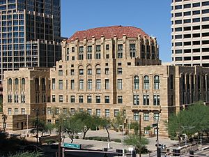
The Maricopa County Courthouse and Old Phoenix City Hall, also known as the County-City Administration Building, in 2013
|
|||
|
|||
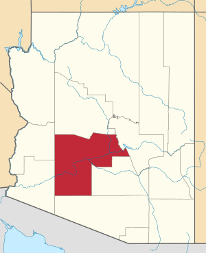
Location within the U.S. state of Arizona
|
|||
 Arizona's location within the U.S. |
|||
| Country | |||
| State | |||
| Founded | February 14, 1871 | ||
| Named for | Maricopa people | ||
| Seat | Phoenix | ||
| Largest city | Phoenix | ||
| Area | |||
| • Total | 9,224 sq mi (23,890 km2) | ||
| • Land | 9,200 sq mi (24,000 km2) | ||
| • Water | 24 sq mi (60 km2) 0.3% | ||
| Population
(2020)
|
|||
| • Total | 4,420,568 | ||
| • Estimate
(2023)
|
4,585,871 |
||
| • Density | 479.246/sq mi (185.038/km2) | ||
| Time zone | UTC−7 (Mountain) | ||
| Congressional districts | 1st, 2nd, 3rd, 4th, 5th, 7th, 8th, 9th | ||
Maricopa County (/ˌmærɪˈkoʊpə/) is a county in the south-central part of the U.S. state of Arizona. As of the 2020 census the population was 4,420,568, or about 62% of the state's total, making it the fourth-most populous county in the United States and the most populous county in Arizona, and making Arizona one of the nation's most centralized states. The county seat is Phoenix, the state capital and fifth-most populous city in the United States.
Maricopa County is the central county of the Phoenix–Mesa–Chandler Metropolitan Statistical Area. The Office of Management and Budget renamed the metropolitan area in September 2018. Previously, it was the Phoenix–Mesa–Glendale metropolitan area, and in 2000, that was changed to Phoenix–Mesa–Scottsdale.
Maricopa County was named after the Maricopa people. Five Indian reservations are located in the county. The largest are the Salt River Pima–Maricopa Indian Community (east of Scottsdale) and the Gila River Indian Community (south of Chandler).
Geography
According to the United States Census Bureau, the county has a total area of 9,224 sq mi (23,890 km2), of which 24 sq mi (62 km2) (0.3%) is covered by water. Maricopa County is one of the largest counties in the United States by area, with a land area greater than that of four other US states. From west to east, it stretches 132 miles (212 km), and 103 miles (166 km) from north to south. It is by far Arizona's most populous county, encompassing well over half of the state's residents. It is the largest county in the United States to have a capital city.
Adjacent counties
- La Paz County – west
- Yuma County – west
- Pima County – south
- Pinal County – southeast and south
- Gila County – east
- Yavapai County – north
National protected areas
- Sonoran Desert National Monument (part)
- Tonto National Forest (part)
Regional parks
Maricopa County has 14 regional parks:
- Adobe Mountain Desert Park
- Chaparral Lake
- Estrella Mountain Regional Park
- Hassayampa River Preserve
- Indian Mesa
- Lake Pleasant Regional Park
- Litchfield Park, Arizona
- Manistee Ranch
- McCormick-Stillman Railroad Park
- Papago Park
- Phoenix Mountains Preserve
- Sahuaro Ranch
- San Tan Mountain Regional Park
- White Tank Mountain Regional Park.
It also has at least 21 protected areas:
- Big Horn Mountains Wilderness
- Daisy Mountain Preserve
- Deer Valley Petroglyph Preserve
- Eagletail Mountains Wilderness
- Harquahala Mountains
- Hells Canyon Wilderness (Arizona)
- Hummingbird Springs Wilderness
- Mesa Grande
- Mummy Mountain (Arizona)
- National Memorial Cemetery of Arizona
- Painted Rock Petroglyph Site
- Sierra Estrella
- Signal Mountain Wilderness
- Sonoran Desert National Monument
- St. Francis Catholic Cemetery
- Superstition Mountains
- Table Top Mountain (Arizona)
- Tonto National Forest
- Wabayuma Peak
- White Tank Mountain Regional Park
- Woolsey Peak
Flora and fauna
From 2009 to 2011, an inventory of all vascular plants growing along the Salt River (Arizona), Gila River, New River and Agua Fria River and their tributaries in the Phoenix metropolitan area was done. In October 2022, Maricopa County Environmental Services Department detected Dengue virus in mosquitoes they had trapped; in November the first locally transmitted case of dengue fever was reported in the County and Arizona state as a whole - previous dengue cases in Maricopa County had been related to travel.
Demographics
| Historical population | |||
|---|---|---|---|
| Census | Pop. | %± | |
| 1880 | 5,689 | — | |
| 1890 | 10,986 | 93.1% | |
| 1900 | 20,457 | 86.2% | |
| 1910 | 34,488 | 68.6% | |
| 1920 | 89,576 | 159.7% | |
| 1930 | 150,970 | 68.5% | |
| 1940 | 186,193 | 23.3% | |
| 1950 | 331,770 | 78.2% | |
| 1960 | 663,510 | 100.0% | |
| 1970 | 971,228 | 46.4% | |
| 1980 | 1,509,175 | 55.4% | |
| 1990 | 2,122,101 | 40.6% | |
| 2000 | 3,072,149 | 44.8% | |
| 2010 | 3,817,117 | 24.2% | |
| 2020 | 4,420,568 | 15.8% | |
| 2023 (est.) | 4,585,871 | 20.1% | |
| U.S. Decennial Census 1790–1960 1900–1990 1990–2000 2010–2020 |
|||
Racial and ethnic composition since 1960
| Racial composition | 2020 | 2010 | 2000 | 1990 | 1980 | 1970 | 1960 |
|---|---|---|---|---|---|---|---|
| White | 59.8% | 73.0% | 77.3% | 84.7% | 86.6% | 94.8% | 94.5% |
| —Non-Hispanic | 53.3% | 58.7% | 66.2% | 77.1% | 81.1% | - | - |
| Black or African American | 5.8% | 5.0% | 3.7% | 3.4% | 3.1% | 3.3% | 3.7% |
| Hispanic or Latino (of any race) | 30.6% | 29.6% | 24.8% | 16.2% | 13.1% | 14.5% | - |
| Asian | 4.6% | 3.5% | 2.1% | 1.7% | - | - | 0.3% |
| Native American | 2.3% | 2.1% | 1.8% | 1.7% | - | - | 1.2% |
| Pacific Islander | 0.2% | 0.2% | 0.1% | - | - | - | - |
| Mixed Race | 13.6% | 2.4% | 2.9% | - | - | - | - |
2010 census
As of the 2010 census, 3,817,117 people, 1,411,583 households, and 932,814 families were living in the county. The population density was 414.9/sq mi (160.2/km2). The 1,639,279 housing units averaged 178.2/sq mi (68.8/km2). The racial makeup of the county was 73.0% white (58.7% non-Hispanic white), 5.0% African American, 3.5% Asian, 2.1% American Indian, 0.2% Pacific islander, 12.8% from other races, and 3.5% from two or more races. Those of Hispanic or Latino origin made up 29.6% of the population. The largest ancestry groups were:
Of the 1,411,583 households, 35.1% had children under 18 living with them, 47.8% were married couples living together, 12.4% had a female householder with no husband present, 33.9% were not families, and 25.9% of all households were made up of individuals. The average household size was 2.67 and the average family size was 3.25. The median age was 34.6 years.
The median income for a household in the county was $55,054 and the median income for a family was $65,438. Males had a median income of $45,799 versus $37,601 for females. The per capita income for the county was $27,816. About 10.0% of families and 13.9% of the population were below the poverty line, including 19.8% of those under age 18 and 7.0% of those age 65 or over.
According to data provided by the United States Census Bureau in October 2015 and collected from 2009 to 2013, 73.7% of the population aged five years and over spoke only English at home, while 20.3% spoke Spanish, 0.6% spoke Chinese, 0.5% Vietnamese, 0.4% Tagalog, 0.4% Arabic, 0.4% German, 0.3% French, 0.3% Navajo, 0.2% Korean, 0.2% Hindi, 0.2% Italian, 0.1% Persian, 0.1% Russian, 0.1% Serbo-Croatian, 0.1% Telugu, 0.1% Polish, 0.1% Syriac, 0.1% Japanese, 0.1% spoke Romanian, and 0.1% spoke other Native North American languages at home.
Religion
In 2010 statistics, the largest religious group in Maricopa County were Catholics, who are organized under the Roman Catholic Diocese of Phoenix with 519,950 Catholics and 99 parishes, and 9 additional eastern rite Catholic parishes. This is followed by 242,732 LDS Mormons with 503 congregations, 213,640 non-denominational adherents with 309 congregations, 93,252 Assembly of God Pentecostals with 120 congregations, 73,207 Southern Baptists with 149 congregations, 35,804 Christian churches and churches of Christ Christians with 29 congregations, 30,014 Evangelical Lutherans with 47 congregations, 28,634 UMC Methodists with 55 congregations, 18,408 Missouri Synod Lutherans with 34 congregations, and 15,001 Presbyterians with 42 congregations. Altogether, 39.1% of the population was claimed as members by religious congregations, although members of historically African-American denominations were underrepresented due to incomplete information. In 2014, the county had 1,177 religious organizations, the fifth most out of all US counties.
Education
- Maricopa County Library District operates the county libraries in Maricopa County.
- The Maricopa County School Superintendent is charged with the general conduct and supervision of the public school system in Maricopa County. The superintendent is one of six county-wide elected officials, elected by the voters of Maricopa County every four years. Since the inception of the office, there have been thirteen Maricopa County School Superintendents. The incumbent, Steve Watson, took office January 1, 2017.
K-12 schools
School districts with territory in the county (no matter how slight, even if the administration and schools are in other counties) include:
Unified:
- Cave Creek Unified School District
- Chandler Unified School District
- Deer Valley Unified District
- Dysart Unified School District
- Fountain Hills Unified School District
- Gila Bend Unified School District
- Gilbert Unified School District
- Higley Unified School District
- Mesa Unified School District
- Nadaburg Unified School District
- Paradise Valley Unified School District
- Peoria Unified School District
- Queen Creek Unified School District
- Saddle Mountain Unified School District
- Scottsdale Unified School District
- Wickenburg Unified School District
Secondary:
- Agua Fria Union High School District
- Buckeye Union High School District
- Glendale Union High School District
- Phoenix Union High School District
- Tempe Union High School District
- Tolleson Union High School District
Elementary:
- Aguila Elementary School District
- Alhambra Elementary School District
- Arlington Elementary School District
- Avondale Elementary School District
- Balsz Elementary School District
- Buckeye Elementary School District
- Cartwright Elementary School District
- Creighton Elementary School District
- Fowler Elementary School District
- Glendale Elementary School District
- Isaac Elementary School District
- Kyrene Elementary School District
- Laveen Elementary School District
- Liberty Elementary School District
- Litchfield Elementary School District
- Littleton Elementary School District
- Madison Elementary School District
- Mobile Elementary School District
- Morristown Elementary School District
- Murphy Elementary School District
- Osborn Elementary School District
- Palo Verde Elementary School District
- Paloma School District
- Pendergast Elementary School District
- Phoenix Elementary School District
- Riverside Elementary School District
- Roosevelt Elementary School District
- Sentinel Elementary School District
- Tempe School District
- Tolleson Elementary School District
- Union Elementary School District
- Washington Elementary School District
- Wilson Elementary School District
There is also a state-operated school, Phoenix Day School for the Deaf.
The Phoenix Indian School was formerly in the county.
Transportation
Major highways
 Interstate 8
 Interstate 10
 Interstate 17
 U.S. Route 60
 Historic U.S. Route 80
 U.S. Route 93
 Loop 101
 Loop 202
 Loop 303
 State Route 24
 State Route 51
 State Route 71
 State Route 74
 State Route 85
 State Route 87
 State Route 143
 State Route 347
Air
The major primary commercial airport of the county is Phoenix Sky Harbor International Airport (PHX).
Other airports located in the county include:
- Phoenix-Mesa Gateway Airport in Mesa (AZA)
- Scottsdale Municipal Airport in Scottsdale (SCF)
- Deer Valley Airport in Deer Valley Village in Phoenix (DVT)
- Chandler Municipal Airport in Chandler (CHD)
- Phoenix Goodyear Airport in Goodyear (GYR)
- Glendale Municipal Airport in Glendale (GEU)
- Buckeye Municipal Airport in Buckeye (BXK)
- Falcon Field in Mesa (MSC)
- Gila Bend Municipal Airport in Gila Bend (E63)
- Wickenburg Municipal Airport in Wickenburg (E25)
Rail
In terms of freight rail, the Union Pacific Railroad and the Burlington Northern Santa Fe Railroad serve the county.
In terms of passenger rail, greater Phoenix is served by a light rail system. The county has no other passenger rail transport as Amtrak's Sunset Limited, which served Phoenix until June 2, 1996, has its closest stop in Maricopa in neighboring Pinal County. The train connects Maricopa to Tucson, Los Angeles, and New Orleans three times a week. However, it does not stop in Phoenix itself.
Communities
Cities
- Apache Junction (mostly in Pinal County)
- Avondale
- Buckeye
- Chandler
- El Mirage
- Glendale
- Goodyear
- Litchfield Park
- Mesa
- Peoria (partly in Yavapai County)
- Phoenix (county seat)
- Scottsdale
- Surprise
- Tempe
- Tolleson
Towns
- Carefree
- Cave Creek
- Fountain Hills
- Gila Bend
- Gilbert
- Guadalupe
- Paradise Valley
- Queen Creek (partly in Pinal County)
- Wickenburg (partly in Yavapai County)
- Youngtown
Census-designated places
Unincorporated communities
Ghost towns
- Agua Caliente
- Alma
- Angel Camp
- Marinette
- Vulture City
Native American communities
- Fort McDowell Yavapai Nation
- Gila River Indian Community
- Salt River Pima–Maricopa Indian Community
- Tohono O'odham Indian Reservation
County population ranking
The population ranking of the following table is based on the 2020 census of Maricopa County.
† county seat
| Rank | City/Town/etc. | Population (2020 Census) | Population (2021 Estimate) | Municipal type | Incorporated |
|---|---|---|---|---|---|
| 1 | Phoenix † | 1,608,139 | 1,624,569 | City | 1881 |
| 2 | Mesa | 504,258 | 509,475 | City | 1878 (founded) |
| 3 | Chandler | 275,987 | 279,458 | City | 1920 |
| 4 | Gilbert | 267,918 | 273,136 | Town | 1920 |
| 5 | Glendale | 248,325 | 249,630 | City | 1910 |
| 6 | Scottsdale | 241,361 | 242,753 | City | 1951 |
| 7 | Peoria (partially in Yavapai County) | 190,985 | 194,917 | City | 1954 |
| 8 | Tempe | 180,587 | 184,118 | City | 1894 |
| 9 | Surprise | 143,148 | 149,191 | City | 1960 |
| 10 | Goodyear | 95,294 | 101,733 | City | 1946 |
| 11 | Buckeye | 91,502 | 101,315 | City | 1929 |
| 12 | Avondale | 89,334 | 90,564 | City | 1946 |
| 13 | Queen Creek (partially in Pinal County) | 59,519 | 66,346 | Town | 1990 |
| 14 | Sun City | 39,931 | -- | CDP | |
| 15 | El Mirage | 35,805 | 36,016 | City | 1951 |
| 16 | Sun City West | 25,806 | -- | CDP | |
| 17 | Fountain Hills | 23,820 | 23,819 | Town | 1989 |
| 18 | Anthem | 23,190 | -- | CDP | |
| 19 | New River | 17,290 | -- | CDP | |
| 20 | Sun Lakes | 14,868 | -- | CDP | |
| 21 | Paradise Valley | 12,658 | 12,682 | Town | 1961 |
| 22 | Wickenburg (partially in Yavapai County) | 7,474 | 7,695 | Town | 1909 |
| 23 | Tolleson | 7,216 | 7,295 | City | 1929 |
| 24 | Youngtown | 7,056 | 7,012 | Town | 1960 |
| 25 | Litchfield Park | 6,847 | 6,942 | City | 1987 |
| 26 | Guadalupe | 5,322 | 5,307 | Town | 1975 |
| 27 | Citrus Park | 5,194 | -- | CDP | |
| 28 | Cave Creek | 4,892 | 5,015 | Town | 1986 |
| 29 | Carefree | 3,690 | 3,685 | Town | 1984 |
| 30 | Rio Verde | 2,210 | -- | CDP | |
| 31 | Gila Bend | 1,892 | 1,887 | Town | 1962 |
| 32 | Komatke | 1,013 | -- | CDP | |
| 33 | Maricopa Colony | 854 | -- | CDP | |
| 34 | St. Johns | 690 | -- | CDP | |
| 35 | Wittmann | 684 | -- | CDP | |
| 36 | Gila Crossing | 636 | -- | CDP | |
| 37 | Aguila | 565 | -- | CDP | |
| 38 | Morristown | 186 | -- | CDP | |
| 39 | Arlington | 150 | -- | CDP | |
| 40 | Theba | 111 | -- | CDP | |
| 41 | Kaka | 83 | -- | CDP | |
| 42 | Wintersburg | 51 | -- | CDP | |
| 43 | Tonopah | 23 | -- | CDP |
Climate
|
||||||||||||||||||||||||||||||||||||||||||||||||||||||||||||||||||||||||||||||||||||||||||||||||
Economy
In 2019, the largest employers in Maricopa County were:
| # | Employer | # of employees |
|---|---|---|
| 1 | Banner Health | 27,650 |
| 2 | State of Arizona | 23,950 |
| 3 | Walmart | 16,870 |
| 4 | Frys Food Stores | 15,170 |
| 5 | Wells Fargo | 13,790 |
| 6 | Maricopa County | 13,350 |
| 7 | City of Phoenix | 12,190 |
| 8 | Intel Corporation | 11,410 |
| 9 | Arizona State University | 10,950 |
| 10 | HonorHealth | 9,430 |
| 11 | JPMorgan Chase Bank National Association | 9,310 |
| 12 | Bank of America | 9,180 |
| 13 | Dignity Health | 9,100 |
| 14 | Amazon | 9,050 |
| 15 | Mesa Unified School District 4 | 8,500 |
| 16 | Honeywell | 8,450 |
| 17 | United States Department of the Air Force | 7,720 |
| 18 | Home Depot | 7,420 |
| 19 | State Farm Insurance | 7,420 |
| 20 | United States Postal Service | 7,260 |
According to the Bureau of Economic Analysis, in 2019 the employment of Maricopa County in the following sectors was:
| Sector | Number of jobs | Percent | National percent |
|---|---|---|---|
| Health care and social assistance | 312,385 | 11.2% | 11.3% |
| Retail trade | 271,802 | 9.8% | 9.4% |
| Administrative and support and waste management and remediation services | 249,786 | 9.0% | 6.2% |
| Finance and insurance | 226,934 | 8.2% | 5.4% |
| Accommodation and food services | 204,917 | 7.4% | 7.5% |
| Professional, scientific, and technical services | 200,508 | 7.2% | 7.2% |
| Construction | 172,119 | 6.2% | 5.5% |
| Real estate and rental and leasing | 169,363 | 6.1% | 4.8% |
| Local government | 152,939 | 5.5% | 7.1% |
| Other services (except government) | 140,788 | 5.1% | 5.8% |
| Manufacturing | 137,444 | 4.9% | 6.7% |
| Transportation and warehousing | 134,151 | 4.8% | 4.5% |
| Wholesale trade | 91,114 | 3.3% | 3.2% |
| Arts, entertainment, and recreation | 64,117 | 2.3% | 2.4% |
| Educational services | 63,445 | 2.3% | 2.4% |
| State government | 49,051 | 1.8% | 2.7% |
| Information | 48,195 | 1.7% | 1.7% |
| Management of companies and enterprises | 35,917 | 1.7% | 1.4% |
| Federal civilian | 21,366 | 0.8% | 1.4% |
| Military | 14,632 | 0.5% | 1.0% |
| Utilities | 8,229 | 0.3% | 0.3% |
| Farming | 6,237 | 0.2% | 1.3% |
| Mining, quarrying, and oil and gas extraction | 5,356 | 0.2% | 0.6% |
| Forestry, fishing, and related activities | 2,994 | 0.1% | 0.5% |
| Total | 2,783,679 | 100% | 100% |
Maricopa produces far more Brassica than anywhere else in the state, including far more cabbage, collards, and mustard greens, and far more eggplant and greenhouse production of tomato. Slightly more kale is grown here than Yavapai, and a close second to Yuma for broccoli, cauliflower, and spinach, and to Yavapai for field tomato. The county is top for parsley and is tied with Pima for other fresh herbs. Some of the state's melon, okra, and bell pepper are also grown here.
Almost all the apricot, freestone peach, persimmon, and nectarine in the state are grown here. The county also ties for the highest amount of cling peach with Cochise, along with Pima produces almost all the pomegranate, and grows most of the kumquat. Maricopa's farms grow a middling amount of fig, grape (Vitis spp. including V. vinifera), and pear (Pyrus spp.) other than Bartlett. A small amount of plum is also produced here.
All of the boysenberry, half of the elderberry (along with Yavapai), and a small amount of the state's blackberry and strawberry are harvested here.
A large part of the vegetable seed in Arizona is grown here.
See also
 In Spanish: Condado de Maricopa para niños


