Name
|
Image |
Notes |
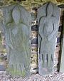
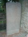
| Brandsbutt Symbol Stone |
 |
An early Pictish symbol stone |
| Corgarff Castle |
 |
Tower house surrounded by a star-shaped perimeter wall of 18th-century date. |
| Cullerlie Stone Circle |
 |
A circle of eight stones |
| Culsh Earth House |
 |
A well-preserved underground passage |
| Deer Abbey |
 |
Remains of a Cistercian monastery |
| Duff House |
 |
Early Georgian mansion designed by William Adam for the Earl of Fife. |
| Dyce Symbol Stones |
 |
Two Pictish stones, one with the older type of incised symbols |
| Easter Aquhorthies Stone Circle |
 |
A recumbent stone circle about 4000 years old |
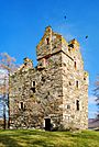
| Glenbuchat Castle |
 |
A Z-plan tower house |
| Huntly Castle |
 |
Ruined baronial residence |
| Invercauld Bridge |
 |
Old Bridge of Dee dating back to 1752, part of the military road built by engineer Major William Caulfield |
| Kildrummy Castle |
 |
13th-century castle |
| Kinkell Church |
 |
Ruins of a 16th-century parish church |
| Kinnaird Head Castle Lighthouse And Museum |
 |
16th-century castle altered in 1787 to take the first lighthouse built by the Commissioners of the Northern Lighthouses |
| Kinnaird Head Winetower |
 |
16th-century tower |
| Knock Castle |
 |
16th-century keep |
| Loanhead Stone Circle |
 |
The best known of a group of recumbent stone circles |
| Maiden Stone |
 |
Pictish cross slab of the 9th century AD |
| Memsie Cairn |
 |
A large stone-built cairn, possibly of Bronze Age date, but enlarged during field clearance during the last two centuries. |
| Peel Ring of Lumphanan |
 |
Site of a fortified residence |
| Picardy Symbol Stone |
 |
Pictish symbol stones |
| St Mary's Kirk, Auchindoir |
 |
Medieval parish church |
| Tarves Medieval Tomb |
 |
Altar tomb of William Forbes |
| Tolquhon Castle |
 |
Castle built by William Forbes, 7th Laird of Tolquhon, from 1584 to 1589 |
| Tomnaverie Stone Circle |
 |
A recumbent stone circle about 4000 years old |
Name
|
Image |
Notes |
| Aberlemno Sculptured Stones |
 |
Range of Pictish sculptured stones depicting a hunting scene, battle scene and an army of men |
| Affleck Castle |
|
15th-century, L-shaped tower house |
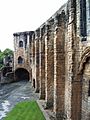
| Arbroath Abbey |
 |
Arbroath Abbey is famous for its association with the Declaration of Arbroath |
| Ardestie Earth House |
 |
A curved underground gallery |
| Brechin Cathedral Round Tower |
 |
One of the two remaining round towers of the Irish type in Scotland |
| Carlungie Earth House |
 |
A complex underground structure of Iron Age date |
| Caterthuns |
 |
Two large hill forts |
| Eassie Sculptured Stone |
 |
An elaborately sculptured Pictish cross-slab |
| Edzell Castle |
 |
Ruined 16th-century castle with an early-17th-century walled garden |
| Lindsay Burial Aisle |
 |
Remains of the 14th-century Edzell Old Church |
| Maison Dieu Chapel, Brechin |
 |
Part of the south wall of a chapel, belonging to a medieval hospital founded in the 1260s |
| Restenneth Priory |
 |
A monastic house of Augustinian canons founded in 1153 |
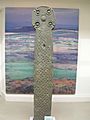
| St Orland's Stone |
 |
A tall, Pictish cross-slab with a prominent, ornate cross |
| St Vigeans Sculptured Stones |
 |
A collection of over 30 Pictish carved stones |
| Tealing Dovecot |
 |
A dovecot of the late 16th century |
| Tealing Earth House |
 |
An Iron Age earth house or souterrain |
Name
|
Image |
Notes |
| Ardchattan Priory |
 |
The ruins of a Valliscaulian priory founded in 1230 and later converted to secular use. |
| Bonawe Historic Iron Furnace |
 |
The most complete charcoal-fuelled ironworks in Britain, founded in 1753. |
| Carnasserie Castle |
 |
Home of John Carswell, first Protestant Bishop of the Isles |
| Castle Sween |
 |
One of the earliest castles in Scotland |
| Dunstaffnage Castle and Chapel |
 |
Stronghold of the MacDougalls |
| Eileach an Naoimh |
 |
Ruins of Early Christian beehive cells, a chapel and a graveyard on a small island in the Firth of Lorne |
| St Cormac's Chapel, Eilean Mor |
 |
A chapel on a small island in the Sound of Jura. Site includes St Cormac's Cross and St Cormac's Cave |
| Inchkenneth Chapel |
 |
Medieval church |
| Iona Abbey |
 |
One of Scotland's most historic and sacred sites. |
| Iona: Maclean's Cross |
 |
A 15th-century free-standing cross |
| Iona Nunnery |
 |
One of the best-preserved medieval nunnery churches in the British Isles. |
| Keills Chapel |
 |
A small West Highland chapel housing a collection of 12th-century grave slabs |
| Kilberry Sculptured Stones |
 |
A collection of late-medieval sculptured stones gathered from the Kilberry estate. |
| Kilchurn Castle |
 |
Four-storey tower built in the mid-15th century by Sir Colin Campbell |
| Kildalton Cross |
 |
The finest intact high cross in Scotland carved in the late 8th century |
| Kilmartin Glen: Achnabreck Cup And Ring Marks |
 |
The exposed crest of a rocky ridge with well-preserved cup and ring marks of early prehistoric date. |
| Kilmartin Glen: Ballygowan Cup And Ring Marks |
 |
Cup and ring marks on natural rock faces, of early prehistoric date. |
| Kilmartin Glen: Baluachraig Cup And Ring Marks |
 |
Several groups of early prehistoric cup and ring marks on natural rock faces. Close to Dunchraigaig cairn. |
| Kilmartin Glen: Cairnbaan Cup And Ring Marks |
 |
Carved stone of the Bronze Age within Kilmartin Glen |
| Kilmartin Glen: Dunadd Fort |
 |
Well-preserved hill fort of Kilmartin Glen |
| Kilmartin Glen: Dunchraigaig Cairn |
 |
Bronze Age cairn within Kilmartin Glen |
| Kilmartin Glen: Glebe Cairn, Kilmartin |
 |
Early Bronze Age burial cairn |
| Kilmartin Glen: Kilmartin Sculptured Stones |
 |
Early-medieval and medieval crosses of Kilmartin Glen |
| Kilmartin Glen: Kilmichael Glassary Cup And Ring Marks |
 |
Early prehistoric cup and ring carvings of Kilmartin Glen |
| Nether Largie Cairns |
 |
A Neolithic and two Bronze Age cairns of Kilmartin Glen |
| Ri Cruin Cairn |
 |
Bronze Age burial cairn within Kilmartin Glen |
| Temple Wood Stone Circles |
 |
Standing stones of Kilmartin Glen dating to about 3000 BC |
| Kilmodan Sculptured Stones |
 |
A group of West Highland carved grave slabs exhibited in a burial aisle within Kilmodan churchyard. |
| Kilmory Knap Chapel |
 |
A small medieval chapel with a collection of typical West Highland grave slabs and some early medieval sculpture. |
| Rothesay Castle |
 |
Castle with a long and close association with the Stewart Kings of Scotland |
| Skipness Castle and Chapel |
 |
A 13th-century castle with a 16th-century tower house in one corner |
| St Blane's Church, Kingarth |
 |
A 12th-century Romanesque chapel |
| St Mary's Chapel, Rothesay |
 |
Late-medieval remains of the chancel of the Parish Church of St Mary |
Name
|
Image |
Notes |
| Barsalloch Fort |
 |
An Iron Age promontory fort, defended by a deep u-shaped ditch. |
| Big Balcraig |
|
Cup and ring marked rocks. |
| Caerlaverock Castle |
 |
Castle with moat, twin towered gatehouse and imposing battlements |
| Cairn Holy Chambered Cairns |
 |
Two Neolithic burial cairns, of a type characteristic of Galloway. |
| Cardoness Castle |
 |
A well-preserved six-storey tower house of the McCulloch dating back to the 15th century. |
| Carsluith Castle |
 |
A well-preserved ruin of a tower house of 16th-century date. |
| Castle of Park |
 |
16th-century L-plan tower house |
| Chapel Finian |
 |
Remains of a small chapel built in the Irish style |
| Druchtag Motte |
 |
An example of a motte castle |
| Drumcoltran Tower |
 |
A well-preserved mid 16th-century tower |
| Drumtroddan Cup And Ring Marked Rocks |
 |
Three groups of well-defined cup and ring marks on bedrock probably carved in the Bronze Age |
| Drumtroddan standing stones |
 |
An alignment of three prehistoric stones |
| Dundrennan Abbey |
 |
Cistercian abbey built in the latter half of the 12th century |
| Glenluce Abbey |
 |
Abbey founded around 1192 |
| Kirkconnel Churchyard |
 |
Ruined church and tombstones |
| Kirkmadrine Early Christian Stones |
 |
Three of the earliest Christian memorial stones in Britain |
| Laggangairn Standing Stones |
 |
Stones carved with early Christian crosses |
| Lincluden Collegiate Church |
 |
Remains of a collegiate church and the accommodation for its canons founded in 1389. |
| Lochmaben Castle |
 |
A Z-plan tower house |
| MacLellan's Castle |
 |
Late 16th-century noble residence |
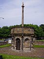
| Merkland Cross |
 |
A carved wayside cross of the 15th century |
| Monreith Cross |
 |
A 10th-century carved stone cross |
| Morton Castle |
 |
A late-13th-century hall house, a stronghold of the Douglases |
| New Abbey Corn Mill |
 |
Fully restored water-powered corn mill |
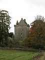
| Orchardton Tower |
 |
Tower house of the mid-15th-century |
| Rispain Camp |
 |
Rectangular settlement defended by a bank and ditch |
| Ruthwell Cross |
 |
Anglian Cross dating from the end of the 7th century |
| St Ninian's Cave |
 |
Cave traditionally associated with St Ninian |
| St Ninian's Chapel |
 |
Restored ruins of a 13th-century chapel, probably used by pilgrims on their way to Whithorn |
| Sweetheart Abbey |
 |
Abbey founded by Lady Dervorgilla of Galloway in memory of her husband John Balliol |
| Threave Castle |
 |
A 14th-century tower built by Archibald the Grim, Lord of Galloway, on an island in the River Dee |
| Torhouse Stone Circle |
 |
A Bronze Age stone circle consisting of 19 boulders |
| Wanlockhead Beam Engine |
 |
An early-19th-century wooden water-balance pump for draining a lead mine |
| Whithorn Priory |
 |
Cradle of Christianity in Scotland |
| Wren's Egg |
 |
Standing stone and Bronze Age cists |
Name
|
Image |
Notes |
| Abbey Strand |
 |
Late 15th-century abbey church |
| Corstorphine Dovecot |
 |
A large circular ‘beehive’ dovecot |
| Craigmillar Castle |
 |
A well-preserved medieval castle, with a tower house, courtyard and gardens. |
| Eagle Rock, Cramond |
 |
A much-defaced carving on natural rock |
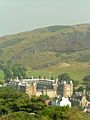
| Edinburgh Castle |
 |
World-famous castle which dominates the sky-line of the city of Edinburgh, |
| Holyrood Abbey |
 |
The ruined nave of the 12th- and 13th-century abbey church, and a three-storey building on Abbey Strand from the late 15th or early 16th century |
| Holyrood Palace |
 |
16th-century residence of Scottish royal family |
| Holyrood Park |
 |
Historic landscape in the heart of the city, with dramatic crags and hills |
| St Triduana's Chapel, Restalrig Collegiate Church |
 |
Shrine of St Triduana, a Pictish saint |
| Trinity House |
 |
Home to a collection of maritime memorabilia |
Name
|
Image |
Notes |
| Antonine Wall: Castlecary |
 |
The low earthworks of a fort |
| Antonine Wall: Rough Castle |
 |
Best-preserved length of rampart and ditch |
| Antonine Wall: Seabegs Wood |
 |
A stretch of rampart and ditch with the military way behind |
| Antonine Wall: Watling Lodge |
 |
A stretch of rampart and ditch |
| Blackness Castle |
 |
Castle built by one of Scotland's most powerful families, the Crichtons |
| Kinneil House |
 |
15th-century tower remodelled by the Earl of Arran |
| Westquarter Dovecot |
 |
Rectangular dovecot with a heraldic panel dated 1647 |
Name
|
Image |
Notes |
| Aberdour Castle |
 |
Castle with a walled garden and terraces with a dovecot |
| Culross Abbey |
 |
The remains of a Cistercian monastery founded in 1217 |
| Dogton Stone |
 |
Once a free-standing cross probably of 9th-century date |
| Dunfermline Abbey |
 |
The Abbey Church is the last resting place of many Scottish kings and queens |
| Dunfermline Palace |
 |
Former Scottish royal palace |
| Inchcolm Abbey |
 |
Group of monastic buildings located on the island of Inchcolm in the Firth of Forth |
| Ravenscraig Castle |
 |
One of the earliest artillery forts in Scotland |
| Scotstarvit Tower |
 |
Renowned as the home of Sir John Scot |
| St Andrews Castle |
 |
The main residence of the bishops and archbishops of St Andrews |
| St Andrews Cathedral |
 |
Remains of medieval Scotland's largest and most magnificent church |
| St Andrews: Blackfriars Chapel |
 |
A vaulted side apse survives of this church of Dominican friars, which was built in about 1516. |
| St Andrews: St Mary's Church, Kirkheugh |
 |
Earliest collegiate church in Scotland |
| St Andrews: West Port |
 |
One of the few surviving city gates in Scotland |
| St Bridget's Kirk |
 |
The shell of a medieval church |
Name
|
Image |
Notes |
| Ardclach Bell Tower |
 |
A fortified bell tower built in 1655 on the hill above the parish church of Ardclach |
| Beauly Priory |
 |
The ruined church of a Valliscaulian priory, one of three founded in 1230 |
| Bridge of Oich |
 |
Suspension bridge |
| Cairn o'Get |
 |
A horned and chambered burial cairn |
| Carn Liath |
 |
A typical Sutherland broch |
| Castle of Old Wick |
 |
The ruin of the best-preserved Norse castle in Scotland |
| Clava Cairns |
 |
A well-preserved Bronze Age cemetery |
| Cnoc Freiceadain Long Cairns |
 |
Two unexcavated long-horned burial cairns of Neolithic date |
| Corrimony Chambered Cairn |
 |
An excavated passage grave of probable Bronze Age date |
| Dun Beag |
 |
A fine example of a Hebridean broch |
| Dun Dornaigil |
 |
A well-preserved broch |
| Fort George |
 |
The mightiest artillery fortification in Britain |
| Fortrose Cathedral |
 |
Beautiful red sandstone cathedral |
| Glenelg Brochs: Dun Telve and Dun Troddan |
 |
Two broch towers |
| Grey Cairns of Camster |
 |
Two chambered burial cairns of Neolithic date |
| Hill O' Many Stanes |
 |
More than 22 rows of low slabs |
| Hilton of Cadboll Chapel |
 |
The foundations of a small rectangular chapel, with a reproduction of a Pictish stone nearby |
| Inverlochy Castle |
 |
One of Scotland's earliest stone castles |
| Knocknagael Boar Stone |
|
A rough slab incised with the Pictish symbols, kept in the Highland Council offices, Inverness |
| Ruthven Barracks |
 |
An infantry barracks erected in 1719 following the Jacobite rising of 1715 |
| St Mary's Chapel, Crosskirk |
 |
A simple dry-stone chapel |
| Urquhart Castle |
 |
Once one of Scotland's largest castles, on the banks of Loch Ness |
Name
|
Image |
Notes |
| Chesters Hill Fort |
 |
One of the best-preserved Iron Age hill forts in Scotland |
| Dirleton Castle |
 |
Medieval fortified residence with garden |
| Doonhill Homestead |
 |
A rare site of the Anglian occupation of southeast Scotland |
| Dunglass Collegiate Church |
 |
Church founded in 1450 |
| Hailes Castle |
 |
A ruin incorporating a fortified manor of 13th-century date |
| Lauderdale Aisle, St Mary's Church |
 |
The former sacristy of the great 15th-century St Mary's Collegiate Church, Haddington |
| Ormiston Market Cross |
 |
Free-standing 15th-century cross |
| Preston Market Cross |
 |
The only surviving example of a market cross of its type on its original site |
| Seton Collegiate Church |
 |
Ecclesiastical kirk set in wooded surroundings |
| St Martin's Kirk, Haddington |
 |
Remains of a Romanesque church |
| Tantallon Castle |
 |
Seat of the Douglas Earls of Angus, one of the most powerful baronial families in Scotland |
Name
|
Image |
Notes |
| Auchindoun Castle |
 |
Castle built about 1480 by Thomas Cochrane, Earl of Mar |
| Balvenie Castle |
 |
Ruined castle built in the 12th century by a branch of the powerful Comyn family |
| Burghead Well |
 |
A rock-cut well |
| Dallas Dhu Historic Distillery |
 |
Distillery built in 1898 to produce malt whisky for Glasgow firm Wright and Greig's popular ‘Roderick Dhu’ blend |
| Deskford Church |
 |
Small late medieval church |
| Duffus Castle |
 |
One of the finest examples of a motte and bailey castle in Scotland |
| Elgin Cathedral |
 |
Home to Scotland's finest octagonal chapter house |
| Elgin Cathedral: Bishop's House |
 |
Partially ruined 15th-century defensible L-plan town house, within the precincts of Elgin Cathedral |
| Elgin Cathedral: Pans Port |
 |
The only surviving medieval archway of Elgin Cathedral's precinct walls |
| Spynie Palace |
 |
Residence of the bishops of Moray |
| St Peter's Kirk and Parish Cross, Duffus |
 |
Remains of a 14th-century western tower and a 16th-century vaulted porch |
| Sueno's Stone |
 |
Pictish monument |
Name
|
Image |
Notes |
| Barnhouse |
 |
Neolithic settlement |
| Bishop's Palace, Kirkwall |
 |
Palace built for the first bishop of Orkney |
| Blackhammer Chambered Cairn |
 |
Neolithic burial cairn |
| Braeside chambered cairn |
 |
Neolithic chambered cairn |
| Breckness Castle |
 |
17th-century mansion house |
| Broch of Gurness |
 |
Iron-Age broch and surrounding settlement |
| Brough of Birsay |
 |
Site featuring Pictish and Norse power-base with Pictish well |
| Brough of Deerness |
 |
Site of an 11th-century norse chapel and Viking settlement |
| Cobbie Row's Castle |
 |
One of the earliest stone castles to survive in Scotland |
| Cuween Hill Chambered Cairn |
 |
Neolithic chambered tomb |
| Dounby Click Mill |
 |
The last surviving horizontal water mill in Orkney |
| Dwarfie Stane |
 |
Neolithic burial chamber |
| Earl's Bu |
 |
Remains of a medieval manor house |
| Earl's Palace, Birsay |
 |
16th-century remains of the residence of Robert Stewart, Earl of Orkney |
| Earl's Palace, Kirkwall |
 |
17th-century palace built by Patrick Stewart, 2nd Earl of Orkney |
| Eynhallow Church |
 |
Ruined 12th-century monastic church |
| Grain Earth House |
 |
Iron Age earth house |
| Hackness Martello Tower and Battery |
 |
19th century fort and battery on the island of South Walls |
| Holland House, Papa Westray |
 |
Early 19th century farm complex built by Laird Thomas Traill |
| Holm of Papa Westray Chambered Cairn |
 |
A massive tomb |
| Huntersquoy chambered cairn |
 |
Neolithic chambered cairn |
| Knap of Howar |
 |
Probably the oldest standing stone houses in north-west Europe |
| Knowe of Yarso Chambered Cairn |
 |
An oval cairn with concentric walls enclosing a Neolithic chambered tomb |
| Lady Kirk |
 |
17th-century church on the island of Westray |
| Links of Noltland |
 |
Sand dunes seal and protect significant prehistoric remains |
| Maeshowe Chambered Cairn |
 |
The finest chambered tomb in north-west Europe |
| Midhowe Broch |
 |
A well-preserved broch, with remains of later buildings around it |
| Midhowe Chambered Cairn |
 |
A megalithic chambered tomb of Neolithic date |
| Noltland Castle |
 |
A ruined Z-plan tower, built between 1560 and 1573 but never completed |
| Orphir Round Church |
 |
Remains of early 12th-century round church next to Earl's Bu |
| Quanterness chambered cairn |
 |
Neolithic chambered cairn |
| Quoygrew settlement, Westray |
 |
Medieval norse settlement on the island of Westray |
| Quoyness Chambered Cairn |
 |
A megalithic tomb containing a passage and main chamber, with six subsidiary cells |
| Rennibister Earth House |
 |
An Orkney earth house |
| Ring of Brodgar |
 |
A circle of upright stones with an enclosing ditch spanned by causeways, dating to late Neolithic period |
| Skara Brae |
 |
One of the best preserved groups of prehistoric houses in Western Europe, part of the Heart of Neolithic Orkney World Heritage Site |
| Stenness Kirk |
 |
19th-century parish church |
| St Boniface's Church, Papa Westray |
 |
Historic church on Papa Westray |
| St Magnus Church, Egilsay |
 |
Ruin of a 12th-century church, graveyard still in use |
| St. Mary's Chapel, Wyre |
 |
Ruin of a 12th-century chapel and graveyard |
| Stones of Stenness |
 |
The remains of a stone circle surrounded by remains of a circular earthen bank |
| Taversöe Tuick Chambered Cairn |
 |
Neolithic chambered cairn |
| Tormiston Mill |
 |
A late example of a Scottish watermill |
| Unstan Chambered Cairn |
 |
A mound covering a stone burial chamber divided by slabs into five compartments |
| Vinquoy chambered cairn |
 |
Neolithic chambered cairn |
| Watchstone |
 |
Standing stone northwest of the Stones of Stenness |
| Westside Church, Tuquoy |
 |
A small 12th-century nave-and-chancel church |
| Wideford Hill chambered cairn |
 |
A Neolithic chambered cairn with three concentric walls and a burial chamber with three large cells |
Name
|
Image |
Notes |
| Abernethy Round Tower |
 |
One of the two round towers of Irish style surviving in Scotland, dating from the end of the 11th century. |
| Ardunie Roman Signal Station |
 |
The site of a Roman watch tower dating to the first century |
| Balvaird Castle |
 |
A late-15th-century tower on an L plan, extended in 1581 by the addition of a walled courtyard and gatehouse. |
| Blackhill Camp |
|
Parts of the defences of two Roman marching camps lying to the north of Ardoch Roman Fort |
| Burleigh Castle |
 |
Complete ruin of a tower house of about 1500 |
| Dunfallandy Stone |
 |
A well-preserved Pictish cross-slab |
| Dunkeld Cathedral |
 |
Cathedral containing a fine effigy of the Robert III's brother |
| Elcho Castle |
 |
Complete 16th-century fortified mansion |
| Fowlis Wester Sculptured Stone |
 |
A tall cross-slab with Pictish symbols |
| Huntingtower Castle |
 |
The House of Ruthven containing a fine painted ceiling |
| Innerpeffray Chapel |
 |
A rectangular collegiate church founded in 1508 |
| Kirkhill Roman Watchtower |
 |
Remains of Roman watchtower dating to the 1st-century |
| Lochleven Castle |
 |
The setting for the most traumatic year in the life of Mary Queen of Scots |
| Meigle Sculptured Stone Museum |
 |
Museum housing a collection of carved stones dating from the late eighth to the late tenth centuries |
| Muir o' Fauld Roman Signal Station |
 |
The site of a 1st-century Roman watch tower on the Gask Ridge |
| Muthill Old Church and Tower |
 |
Ruins of an important medieval parish church |
| St Mary's Church, Grandtully |
 |
A 16th-century parish church |
| St Serf's Church, Dunning and Dupplin Cross |
 |
Picturesque parish church with Pictish cross |
| St Serf's Inch Priory |
 |
Ruins of 12th-century priory on St Serf's Inch island in Loch Leven |
| Stanley Mills |
 |
A unique complex of water-powered cotton mills situated on the River Tay. |
| Sunnybrae Cottage |
 |
Possibly the oldest house in Pitlochry |
| Tullibardine Chapel |
 |
One of the most complete and unaltered small medieval churches in Scotland |
Name
|
Image |
Notes |
| Cross Kirk, Peebles |
 |
Remains of a Trinitarian Friary |
| Dere Street Roman Road, Soutra |
 |
Stretch of Roman road |
| Dryburgh Abbey |
 |
Medieval abbey ruins |
| Edin's Hall Broch |
 |
One of the few Iron Age brochs in lowland Scotland |
| Edrom Arch |
 |
Romanesque doorway in the graveyard of Edrom church |
| Foulden Tithe Barn |
 |
A two-storey barn used for storing payments made in grain to the parish church |
| Greenknowe Tower |
 |
Tower house built in 1581 |
| Hermitage Castle |
 |
13/14th-century castle |
| Jedburgh Abbey |
 |
Abbey, founded in 1138, which was a frequent target for invading border armies. |
| Kelso Abbey |
 |
West end of the great abbey church of the Tironensians |
| Melrose Abbey |
 |
Ruined abbey on a grand scale with lavishly decorated masonry |
| Melrose Abbey: Commendator's House |
 |
15th-century accommodations for the Abbey Commendator |
| Smailholm Tower |
 |
Well-preserved 15th-century rectangular tower |
Name
|
Image |
Notes |
| Cambuskenneth Abbey |
 |
Home to the tomb of James III and Queen Margaret and a display of medieval graveslabs and architectural fragments. |
| Doune Castle |
 |
A late-14th-century courtyard castle built for the Regent Albany |
| Doune Roman Fort |
 |
Roman fort from the 1st-century |
| Dunblane Cathedral |
 |
Medieval church. The lower part of the tower is Romanesque, but the larger part of the building is of the 13th century. |
| Inchmahome Priory |
 |
Augustinian monastery dating from 1238 set on an island in the Lake of Menteith |
| Stirling Castle |
 |
One of Scotland's grandest castles due to its imposing position and impressive architecture. |
| Stirling: Argyll's Lodging |
 |
A near-complete example of a 17th-century townhouse. |
| Stirling: King's Knot |
 |
Earthworks of a formal garden |
| Stirling: Mar's Wark |
 |
Renaissance mansion built by the Earl of Mar |
| Stirling: Old Bridge |
 |
A bridge built in the 15th or early 16th century |


.jpg)


_-_geograph.org.uk_-_852041.jpg)


.jpg)
_-_geograph.org.uk_-_490895.jpg)


.JPG)


_20090614_02.jpg)


_20100920_Lauderdale_Aisle.jpg)


.JPG)


_-_geograph.org.uk_-_3003.jpg)


_20090617.jpg)

.jpg)


.jpg)


_(7986068694).jpg)


.jpg)