Langlade County, Wisconsin facts for kids
Quick facts for kids
Langlade County
|
||
|---|---|---|

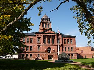
Langlade County Courthouse in 2014
|
||
|
||

Location within the U.S. state of Wisconsin
|
||
 Wisconsin's location within the U.S. |
||
| Country | ||
| State | ||
| Created | March 3, 1879 | |
| Named for | Charles Michel de Langlade | |
| Seat | Antigo | |
| Largest city | Antigo | |
| Area | ||
| • Total | 888 sq mi (2,300 km2) | |
| • Land | 871 sq mi (2,260 km2) | |
| • Water | 17 sq mi (40 km2) 1.9%% | |
| Population
(2020)
|
||
| • Total | 19,491 | |
| • Estimate
(2023)
|
19,404 |
|
| • Density | 22.4/sq mi (8.6/km2) | |
| Time zone | UTC−6 (Central) | |
| • Summer (DST) | UTC−5 (CDT) | |
| Congressional district | 7th | |
Langlade County is a county located in the U.S. state of Wisconsin. As of the 2020 census, the population was 19,491. Its county seat is Antigo.
Contents
History
Langlade County was created on March 3, 1879, as New County. It was renamed Langlade County, in honor of Charles de Langlade, on February 20, 1880, and fully organized on February 19, 1881. The county's original borders extended northward from the top of Shawano County up to the Michigan state line. Between 1881 and 1885, the borders of Langlade County changed as nearby Lincoln and Shawano counties added or gave up area. Langlade lost its northernmost area along the Michigan border to Forest County when it was created in 1885.
Geography
According to the U.S. Census Bureau, the county has a total area of 888 square miles (2,300 km2), of which 871 square miles (2,260 km2) is land and 17 square miles (44 km2) (1.9%) is water. The highest point in the county is at the foot of the Basswood Lookout Tower, west of Summit Lake (elev: 1857').
Adjacent counties
- Oneida County - northwest
- Forest County - northeast
- Oconto County - east
- Menominee County - southeast
- Shawano County - south
- Marathon County - southwest
- Lincoln County - west
National protected area
- Nicolet National Forest (part)
Demographics
| Historical population | |||
|---|---|---|---|
| Census | Pop. | %± | |
| 1880 | 685 | — | |
| 1890 | 9,465 | 1,281.8% | |
| 1900 | 12,553 | 32.6% | |
| 1910 | 17,062 | 35.9% | |
| 1920 | 21,471 | 25.8% | |
| 1930 | 21,544 | 0.3% | |
| 1940 | 23,227 | 7.8% | |
| 1950 | 21,975 | −5.4% | |
| 1960 | 19,916 | −9.4% | |
| 1970 | 19,220 | −3.5% | |
| 1980 | 19,978 | 3.9% | |
| 1990 | 19,505 | −2.4% | |
| 2000 | 20,740 | 6.3% | |
| 2010 | 19,977 | −3.7% | |
| 2020 | 19,491 | −2.4% | |
| U.S. Decennial Census 1790–1960 1900–1990 1990–2000 2010 2020 |
|||
2020 census
As of the census of 2020, the population was 19,491. The population density was 22.4 people per square mile (8.6 people/km2). There were 12,138 housing units at an average density of 13.9 units per square mile (5.4 units/km2). The racial makeup of the county was 93% White, 1.3% Native American, 0.5% Black or African American, 0.4% Asian, 0.7% from other races, and 4.1% from two or more races. Ethnically, the population was 2.4% Hispanic or Latino of any race.
Transportation
Major highways
 U.S. Highway 45
 Highway 17 (Wisconsin)
 Highway 47 (Wisconsin)
 Highway 52 (Wisconsin)
 Highway 55 (Wisconsin)
 Highway 64 (Wisconsin)
Airport
- KAIG - Langlade County Airport
The county owns and operates the Langlade County Airport, which serves both the local and transient general aviation community.
Communities

City
- Antigo (county seat)
Village
- White Lake
Towns
Census-designated places
- Elcho
- Post Lake
- Summit Lake
Unincorporated communities
Ghost towns/neighborhoods
- Kent/Drexel
- Van Ostrand
See also
 In Spanish: Condado de Langlade para niños


