La Pine, Oregon facts for kids
Quick facts for kids
La Pine, Oregon
|
|
|---|---|

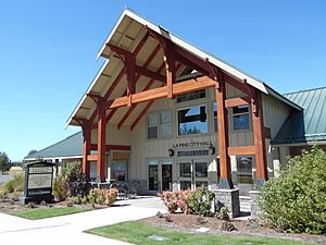
La Pine City Hall
|
|

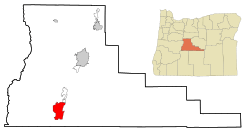
Location of La Pine, Oregon
|
|
| Country | United States |
| State | Oregon |
| County | Deschutes |
| Area | |
| • Total | 7.14 sq mi (18.49 km2) |
| • Land | 7.14 sq mi (18.49 km2) |
| • Water | 0.00 sq mi (0.00 km2) |
| Elevation | 4,236 ft (1,291 m) |
| Population
(2020)
|
|
| • Total | 2,512 |
| • Density | 351.92/sq mi (135.88/km2) |
| Demonym(s) | Lapinese |
| Time zone | UTC-8 (Pacific (PST)) |
| • Summer (DST) | UTC-7 (PDT) |
| ZIP code |
97739
|
| Area code(s) | 541 |
| FIPS code | 41-41050 |
| GNIS feature ID | 1144724 |
| Website | www.lapineoregon.gov |

La Pine is a city in Deschutes County, Oregon, United States, incorporated on December 7, 2006.
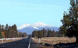
La Pine is part of the Bend, Oregon Metropolitan Statistical Area. The population was 2,512 people as of the 2020 Census. La Pine is in an isolated area of Central Oregon, consisting of a loose collection of homes and businesses along U.S. Highway 97 about 30 miles (48 km) southwest of Bend. Several peaks of the Cascade Range are prominently visible from the community.
La Pine is in the valley of the Little Deschutes River, a tributary of the Deschutes River. The river provides recreational opportunities such as fishing, swimming, canoeing and other leisure activities.
Contents
History
The area's first European-American settlement was established in the 1800s by French fur trappers. La Pine was founded in the 19th century with Huntington Road as the main street. The original name for the community was Rosland. A post office by that name was started in 1897, followed by a townsite in 1900. Construction on the Oregon Trunk Railroad started in 1908 by the Spokane, Portland and Seattle Railway at the Columbia River. The route was designed to follow the Deschutes River, and the line later became part of BNSF Railway. The line was built to Bend, with the railroad later buying a line owned by the Shevlin-Hixon Lumber Company that continued to La Pine. What became U.S. 97 was completed in 1917, which used the right of way of the Oregon Trunk Line that had not been built south of Bend.
In 2000, a branch of the Deschutes Public Library was built in the community. La Pine had remained an unincorporated community for many years. A measure to incorporate in the 2000 elections was rejected by a 2–1 ratio. In the elections of 2006, another incorporation measure was placed on the ballot (one of two such measures in Oregon that year; the other being for Bull Mountain, Oregon). The measure passed, creating the City of La Pine. The city occupies 7 square miles (18 km2), and at the time of incorporation in December 2006, had 1,585 residents. Much of the former census-designated area lies outside the city limits.
Geography
According to the United States Census Bureau, the city has a total area of 6.98 square miles (18.08 km2), all of it land.
Transportation
The main road in the city is U.S. Route 97, which runs north–south through the entire city. Oregon Route 31's northern terminus is approximately one mile (1.6 km) south of the city limits. A rail line of Burlington Northern Santa Fe Railway also runs through La Pine, parallel to U.S. 97.
Demographics
| Historical population | |||
|---|---|---|---|
| Census | Pop. | %± | |
| 2010 | 1,653 | — | |
| 2020 | 2,512 | 52.0% | |
| U.S. Decennial Census | |||
2020 Census
As of the 2020 Census there were 2,512 people, 1,226 housing units, and 1,220 households. During the 2020 Census, the 2020 American Community Survey was also collected from a subset of Census-taking households.
Population
83.3% of people were 18 years of age and older; 20.4% of people were age 65 and older; 16.7% of people were under 18 years of age, and 5.0% percent of people were under 5 years of age. The median age was 48.8 years, older than the Oregon-wide median age of 39.5 years.
In 2020, 6.2% of people had moved to La Pine from within the same county; 3.6% had moved from a different county within Oregon; 1.5% had moved from a different state; 0.2% had moved to La Pine from beyond the United States.
28.3% of people in La Pine claimed Irish ancestry; 26.9% claimed German ancestry; 6.2% claimed English ancestry; 3.1% claimed Norwegian ancestry; 2.0% claimed Italian ancestry; 1.7% claimed French ancestry; 1.5% claimed Scottish ancestry, and 0.2% claimed Polish ancestry. 8.9% of people spoke a language other than English at home, compared to the Oregon-wide average of 15.3%.
Education
9.6% of people had completed a bachelor's degree or higher, compared to the all-Oregon average of 34.4%; 13.1% had completed an associate degree; 28.5% had attended some college without completing a degree; 31.6% had earned a high school diploma or equivalent; 3.0% of people had earned a graduate or professional degree. 78.6% of students currently enrolled were enrolled in kindergarten through 12th grade; 18.0% were enrolled in an undergraduate program; 3.4% were enrolled in a graduate or professional program.
Veterans
11.6% of people in La Pine claimed status as United States military veterans, compared to the all-Oregon average of 8.3%
Employment
The employment rate was 44.2%, compared to the all-Oregon average of 59.1%. The median household income was $37,979, compared to the Oregon-wide median household income of $65,667.
78.0% of workers were employees of private companies; 4.0% of workers worked for the local, state or federal government, compared to the all-Oregon average of 13.8%; 2.9% of workers were self employed in their own incorporated business; 12.7% of people were self-employed in their own not-incorporated business or were unpaid family workers. The number of women workers in industries such as Agriculture, Forestry, Fishing and Hunting; as well as in Computer, Engineering and Science Occupations, was statistically 0.0% at the time of the Census, compared to the all-Oregon averages of 20.0% and 27.5%, respectively.
Poverty
14.8% of people in La Pine were considered to be living in poverty, compared to the all-Oregon average of 12.4%, including more than 1 out of every 10 of seniors. Of those experiencing poverty at the time of the Census, 21.0% of people experiencing poverty were under the age of 18; 14.2% of people experiencing poverty were between 18 and 64 years of age; and 11.7% were 65 years of age or older.
2010 census
At the 2010 census, there were 1,653 people in 698 households, including 412 families, in the city. The population density was 236.8 inhabitants per square mile (91.4/km2). There were 942 housing units at an average density of 135.0 units per square mile (52.1 units/km2). The racial makeup of the city was 93.5% White, 0.2% African American, 1.1% Native American, 0.2% Asian, 0.1% Pacific Islander, 1.8% from other races, and 3.0% from two or more races. Hispanic or Latino of any race were 5.8% of the population.
Of the 698 households 28.5% had children under the age of 18 living with them, 42.6% were married couples living together, 11.6% had a female householder with no husband present, 4.9% had a male householder with no wife present, and 41.0% were non-families. 31.2% of households were one person and 15.5% were one person aged 65 or older. The average household size was 2.30 and the average family size was 2.87.
The median age was 43.6 years. 22.4% of residents were under the age of 18; 6.8% were between the ages of 18 and 24; 22.7% were from 25 to 44; 30.4% were from 45 to 64; and 17.8% were 65 or older. The gender makeup of the city was 48.4% male and 51.6% female.
Education
La Pine schools, such as La Pine Senior High School, are part of the Bend-La Pine School District.
See also
 In Spanish: La Pine para niños

