Jones County, Iowa facts for kids
Quick facts for kids
Jones County
|
|
|---|---|
|
|
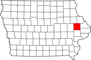
Location within the U.S. state of Iowa
|
|
 Iowa's location within the U.S. |
|
| Country | |
| State | |
| Founded | December 21, 1837 |
| Named for | George Wallace Jones |
| Seat | Anamosa |
| Largest city | Anamosa |
| Area | |
| • Total | 577 sq mi (1,490 km2) |
| • Land | 576 sq mi (1,490 km2) |
| • Water | 1.4 sq mi (4 km2) 0.2% |
| Population
(2020)
|
|
| • Total | 20,646 |
| • Density | 35.78/sq mi (13.815/km2) |
| Time zone | UTC−6 (Central) |
| • Summer (DST) | UTC−5 (CDT) |
| Congressional district | 1st |
Jones County is a county in the U.S. state of Iowa. As of the 2020 census the population was 20,646. The county seat is Anamosa. The county was founded in 1837 and named after George Wallace Jones, a United States senator and member of Congress.
Jones County is included in the Cedar Rapids Metropolitan Statistical Area.
Contents
Geography
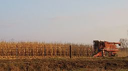
According to the U.S. Census Bureau, the county has a total area of 577 square miles (1,490 km2), of which 576 square miles (1,490 km2) is land and 1.4 square miles (3.6 km2) (0.2%) is water.
Major highways
Airport
Monticello Regional Airport (MXO) serves the county and surrounding communities.
Adjacent counties
- Delaware County (northwest)
- Dubuque County (northeast)
- Jackson County (east)
- Clinton County (southeast)
- Cedar County (south)
- Linn County (west)
Parks
- Wapsipinicon State Park - Anamosa
- Central Park
- Pictured Rocks County Park
- Wapsipinicon State Park – This 400-acre park includes hiking, climbing, nature study, fishing in the Wapsipinicon River, modern camping, picnicking and golf. The park is covered with vegetation and trees, and hik¬ing reveals a multitude of flowers and wildlife. A road makes a complete circle of the park, winding between the river and bluffs, where the view is great. Included along the drive is a trip through the oldest plant¬ing of white pine in Iowa. There are also several caves such as Horse Thief Cave and Ice Cave. The Wapsi has long been famous for its channel and flathead catfish, as well as spring crappies and bullheads, especially below the dam at the park's entrance. Bass, walleye and northern also inhabit the waters. Of the 30 campsites, 15 have electricity. Running water and hot showers are available for modern camping, and mushroom hunting is allowed. Wapsipinicon Country Club maintains a nine-hole golf course in the park. The park has two lodges – one heated and one for summer use – that are available upon reservation with the park ranger. For more information, call 319-462-2761. For information about golfing, call the Wapsipinicon Country Club at 319-462-3930.
- Central Park: This 217-acre park is located four miles southeast of Amber off County Roads X44 and E29 and Central Park Road. Campsites and the park's 25-acre lake are the main draws to Central Park. Campsites range from primitive to full hook-up. Central Parks other amenities include a swimming beach, sand volleyball area, horseshoe pits, playground, boat ramp, hiking trails, rental pavilions, handicapped-accessible fishing pier, picnic areas, rental cabins and a nature center. The Central Park Nature Center is open 1-5 p.m. Saturdays and Sundays, Memorial Day through Labor Day weekend.
- Pictured Rocks Park – Located south of Monticello off Highway 38, this park offers hiking, climbing and access to the Maquoketa River. Picnic shelters, restrooms, playground equipment, and a boat ramp are available.
- Whitewater Canyon – Known for its beauty, the Whitewater Canyon area totals 562 acres of timber, restored prairie, and riverine habitat. Public hunting and fishing are allowed, and mowed hiking trails provide year-round recreational opportunities. This area is located east of Cascade on Highway 151, and south on Curoe Road.
- Mon-Maq Dam – Located one mile northeast of Monticello along the Maquoketa River, this river access includes 63 acres of riverine habitat. Known for its fishing holes, the Mon-Maq Dam area provides fishing fun for local anglers. Sandy areas downstream from the dam serve as put-in sites for canoeists and kayakers.
Demographics
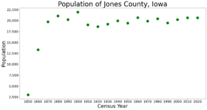
| Historical population | |||
|---|---|---|---|
| Census | Pop. | %± | |
| 1850 | 3,007 | — | |
| 1860 | 13,306 | 342.5% | |
| 1870 | 19,731 | 48.3% | |
| 1880 | 21,052 | 6.7% | |
| 1890 | 20,233 | −3.9% | |
| 1900 | 21,954 | 8.5% | |
| 1910 | 19,050 | −13.2% | |
| 1920 | 18,607 | −2.3% | |
| 1930 | 19,206 | 3.2% | |
| 1940 | 19,950 | 3.9% | |
| 1950 | 19,401 | −2.8% | |
| 1960 | 20,693 | 6.7% | |
| 1970 | 19,868 | −4.0% | |
| 1980 | 20,401 | 2.7% | |
| 1990 | 19,444 | −4.7% | |
| 2000 | 20,221 | 4.0% | |
| 2010 | 20,638 | 2.1% | |
| 2020 | 20,646 | 0.0% | |
| 2023 (est.) | 20,900 | 1.3% | |
| U.S. Decennial Census 1790-1960 1900-1990 1990-2000 2010-2018 |
|||
2020 census
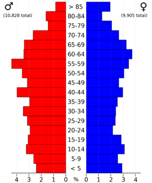
The 2020 census recorded a population of 20,646 in the county, with a population density of 35.8879/sq mi (13.8564/km2). 96.76% of the population reported being of one race. 90.80% were non-Hispanic White, 2.14% were Black, 2.41% were Hispanic, 0.26% were Native American, 0.29% were Asian, 0.01% were Native Hawaiian or Pacific Islander and 4.10% were some other race or more than one race. There were 8,871 housing units, of which 8,113 were occupied.
2010 census
The 2010 census recorded a population of 20,638 in the county, with a population density of 35.8728/sq mi (13.8506/km2). There were 8,911 housing units, of which 8,151 were occupied.
Communities
Cities
Census-designated places
Other unincorporated communities
- Canton (partial)
- Center Junction
- Fairview
- Langworthy
- Oxford Mills
Townships
- Cass
- Castle Grove
- Clay
- Fairview
- Greenfield
- Hale
- Jackson
- Lovell
- Madison
- Monticello
- Oxford
- Richland
- Rome
- Scotch Grove
- Washington
- Wayne
- Wyoming
Population ranking
The population ranking of the following table is based on the 2020 census of Jones County.
† county seat
| Rank | City/Town/etc. | Municipal type | Population (2020 Census) |
|---|---|---|---|
| 1 | † Anamosa | City | 5,450 |
| 2 | Monticello | City | 4,040 |
| 3 | Cascade (partially in Dubuque County) | City | 2,386 |
| 4 | Olin | City | 651 |
| 5 | Wyoming | City | 523 |
| 6 | Oxford Junction | City | 424 |
| 7 | Martelle | City | 249 |
| 8 | Onslow | City | 201 |
| 9 | Stone City | CDP | 186 |
| 10 | Center Junction | CDP | 100 |
| 11 | Morley | City | 96 |
See also
 In Spanish: Condado de Jones (Iowa) para niños


