Jacob Riis Park facts for kids
Quick facts for kids Jacob Riis Park |
|
|---|---|
 |
|
| Type | Public park |
| Location | Queens, New York City, New York, United States |
| Area | 262 acres (106 ha) |
| Created | 1937 |
| Operated by | National Park Service |
| Status | Open all year |
| Public transit access | Bus: Q22, Q35 |
|
Jacob Riis Park Historic District
|
|
| Location | New York, New York |
| Built | 1932 |
| Architect | John L. Plock, Gilmore D. Clarke, Aymar Embury II, Clinton Loyd, Julius Burgevin |
| Architectural style | Art Deco, Moorish |
| NRHP reference No. | 81000081 |
| Added to NRHP | June 17, 1981 |
Jacob Riis Park, also called Jacob A. Riis Park and Riis Park, is a seaside park at the southwestern end of the Rockaway Peninsula in the New York City borough of Queens. It lies at the foot of the Marine Parkway–Gil Hodges Memorial Bridge, east of Fort Tilden, and west of Neponsit and Rockaway Beach. Originally run by the New York City Department of Parks and Recreation, it is now part of the Jamaica Bay Unit of the Gateway National Recreation Area, and is managed by the National Park Service (NPS). It features an extensive sand beach along the Atlantic Ocean coastline and several historic Art Deco structures.
In 1912, the city, urged on by social journalist Jacob Riis, acquired the land for a park initially called Seaside Park and later Telawana Park. In 1914, the park was renamed for Riis. During World War I, the site was used as the Rockaway Naval Air Station, one of the first naval air stations in the United States and, in 1919, the launching point for the first transatlantic flight.
The signature bathhouse was built in 1932, but much of the park's infrastructure and approaches were built between 1936 and 1937 by New York City Parks Commissioner Robert Moses, who envisioned it as a getaway for New York City residents, like Jones Beach State Park further east on Long Island. The park was built along with the Marine Parkway Bridge and the Belt Parkway in nearby Brooklyn, which provided access to the park.
After a period of decline, Jacob Riis Park was transferred in 1974 to the control of the National Park Service. The Jacob Riis Park Historic District was listed on the National Register of Historic Places in 1981.
Contents
Description
(background) in 1956. | width = 250 | footer = | footer_align = left }}-->
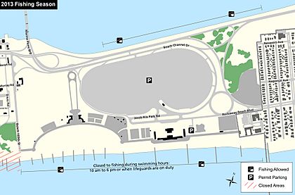
Jacob Riis Park is located at the west end of the Rockaway Peninsula, between Fort Tilden and the Marine Parkway–Gil Hodges Memorial Bridge to the west, and the Neponsit neighborhood to the east. The Roxbury and Breezy Point neighborhoods sit farther west. The Atlantic Ocean coast marks the south end of the site, where the park's beaches are located. The north end is bound by Beach Channel Drive and the Jamaica Bay shore. The park is approximately 262 acres (106 ha) in size, extending 1 mile (1.6 km) east-to-west between Beach 149th Street in Neponsit and Beach 169th Street at Fort Tilden.
The major east-to-west thoroughfares running across the park are Beach Channel Drive and Rockaway Beach Boulevard, the latter of which runs near the south end of the park at the north end of the beach. Beach Channel Drive feeds west into the Marine Parkway Bridge, and into Rockaway Point Boulevard which runs to Roxbury and Breezy Point. Both roads run east towards the rest of the Rockaways. A roundabout at the east end of the park provides an interchange between the two roads. The road layout was designed in the 1930s.
Three buildings constructed in the 1930s are the primary features of the Riis Park Historical District. These are the bathhouse and the two Central Mall buildings. Many elements of the park, including the mall buildings, boardwalk, and renovations to the bathhouse, were completed during the 1936-1937 renovation of the park with Works Progress Administration funds, under the watch of Robert Moses, Gilmore D. Clarke, and Aymar Embury II.
Features
Bathhouse
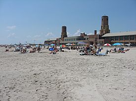
Located on the south side of Rockaway Beach Boulevard near the horizontal center of the park is the bathhouse, which has historically served as the entrance to the beach. It was first completed in 1932, designed by John L. Plock of the Stoughton and Plonck firm in Moorish/Byzantine style. The 1936-1937 WPA project led to a reconfiguration of the bathhouse, designed by Clinton Loyd, which added Art Deco/Art Moderne elements. The alteration in architectural style is said to have been brought on by Robert Moses being "annoyed" by the bathhouse's original Moorish elements. The bathhouse measures approximately 640 feet (200 m) long and 250 feet (76 m) wide. It was modeled after the Jones Beach bathhouse, and is similar in design to other bathing pavilions of the early 20th century. It is the largest building in the park.
The bathhouse actually consists of four individual structures making up each face of the building, linked by common outer screen walls, with a central courtyard in between. The screen walls are brick and rise 8 feet (2.4 m) high. The buildings share a common outer facade in terms of materials, consisting of brick laid in american bond, cast stone, and concrete. After the 1937 renovations, the entire structure was painted in light gray.
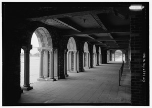
At the front or north face of the site on Rockaway Beach Boulevard is the Entry Pavilion. The one-story structure was built in 1932 as part of the original bathhouse, and retains its Moorish and Byzantine features. Loosely T-shaped, it occupies 10,000 square feet (930 m2) of space. The front face of the building features two small towers or turrets near each end, with an octagonal shape. In between the towers is an arcade, with five brick archways supported by concrete Corinthian columns. The columns are hexagonal in shape with arabesque features. An additional archway is located at both the east and west ends of the arcade. Six hipped skylights are located on the roof of the pavilion.
At the rear of the bathhouse, facing the beach, is the "bathing pavilion" or "beach pavilion", often simply called the "bathhouse". It is two stories high and rectangular in shape, made up of two brick side sections and a concrete center section. Although built as a part of the 1932 bathhouse, the building underwent extensive renovations during the 1936-1937 projects, leading to its current Art Deco characteristics. Unlike the entrance pavilion which is relatively small, the beach pavilion extends the entire east-west length of the building. An arcade or colonnade is located on the ground floor of the center section, largely concrete with columns. The original design of the beach pavilion was similar to that of the entrance building, with numerous Moorish arches forming its arcade. On the second floor on top of the arcade is a concrete projection with rounded edges, enclosed by glass brick windows. These windows are not original to the structure. The projection originally contained a cafeteria or restaurant and its kitchen. It also doubled as a solarium, and is often referred to as such. A terrace surrounds the projection. The center section's roof is flat, used as an additional terrace, while the side sections have hipped roofs. The beach pavilion contains two octagonal towers which rise four stories high with copper roofs. Several windows are located on the towers. External stairs on either side originally led from the beach to the terrace on the second floor, with additional staircases to the roof of the structure; the outdoor stairs from the ground have since been removed.
At the east and west ends of the bathhouse are the east and west wing buildings. The wings are identical one-story rectangular buildings. They were built with the original bathhouse, with the east wing renovated in 1936. The wings each feature a hipped roof of asphalt tiles. Both wings originally contained public bathrooms, with east wing containing a police sub-station for the United States Park Police, and the west wing housing first aid stations. Much of this space has since been converted into visitor facilities, with bathrooms still present in the east wing.
At the core of the bathhouse between the four buildings is the central courtyard. Now open space, the courtyard was initially used for dressing rooms, built with numerous cabana-shaped lockers, along with shower facilities. The western courtyard was for women, while the eastern court was for men. There were 500 changing rooms, containing 8,100 individual lockers. Of these, 5,400 lockers were located in the men's section, while the women's quarters held 2,700. The capacity was later increased to 10,000 during the 1936-1937 expansion, with 6,000 men's lockers and 4,000 women's lockers. The changing rooms were constructed of asbestos board, while the showers were tile with stone trim. The changing rooms were closed and removed by 1988 due to a lack of maintenance and sanitary concerns. Entrance to the changing rooms was via doors at the sides of the front and rear arcades.
Among the other original features of the bathhouse were two restaurants, a cafeteria, concession stands, and the solarium on the roof. These were later replaced by a ranger station, the park police station, and the first-aid station. An eastern portion of the beach pavilion is currently used to house lifeguards from the National Park Service. The bathhouse has received damage from numerous storms, including Hurricane Irene and Hurricane Sandy. Although a $20 million restoration of the bathhouse was started in the 1990s, the renovation project was only partially completed.
Central Mall
Near the foot of the Marine Parkway Bridge between the parking lot and golf course (see § Additional features) is the park's central mall, a landscaped concourse which runs north-to-south between Beach Channel Drive and the main beach. The mall was laid out to be aligned with the Empire State Building, providing a distant view of the Manhattan skyscraper. At the south end of the mall is a concrete plaza with two structures known as the Central Mall Buildings or the Bay 9 Mall Buildings. The buildings were erected during the 1936-1937 park projects, designed in Art Deco/Art Moderne style. The outer facade consists of brick and tile with concrete trim and roofing. The two buildings are mirror images of each other, standing one-story high. They are semi-circle shaped, opening towards the main beach; the two buildings together form a horseshoe. Each structure occupies 6,000 square feet (560 m2) of space. The western building contains offices and public toilets, along with a small bathhouse. The eastern structure is used as a concession stand, with retail space at its eastern end, and a patio area in front of it. Like the bathhouse, the mall buildings were painted gray upon opening in 1937. A bandstand was originally located in between the two buildings in the center of the plaza, but was removed in 1954.
A bronze bust of Jacob Riis had been installed adjacent to the western mall building in 1940, donated by Riis' son Roger. The bust rested on a granite pedestal constructed by the Parks Department with money from the Triborough Bridge and Tunnel Authority, the highway agency also controlled by Robert Moses. After it was stolen in 1964, only its granite base remained. A replacement bronze bust was constructed by artist David Ostro, organized by students at the Immaculate Conception Catholic Academy in Jamaica Estates. The new bust was installed on April 17, 2010.
Boardwalk
Running along the north end of the entire beach is the boardwalk, also sometimes called the promenade. The majority of the boardwalk was built during the 1936-1937 park projects, with the portion in front of the bathhouse built in 1932. The boardwalk separates the beach from the "back beach" portions of the park, such as the bathhouse, central mall, and non-beach recreation areas (see § Central Mall and § Additional features). It is the primary means of pedestrian circulation through the park. The boardwalk is 40 feet (12 m) wide, except at the bathhouse where it is 70 feet (21 m) wide. It was originally wood, but was upgraded to concrete in 1970.
The boardwalk is built on top of the beach's concrete seawall or bulkhead, which stabilizes the sand and protects the back beach from flooding. The original seawall was constructed in 1931 and ran parallel to the south face of the bathhouse. Portions of the old sea wall remain on the beach.
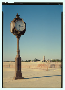
Located on the boardwalk at the east end of the main beach is a street clock, known as the Wise Clock or Riis Park Memorial Clock. It was donated by Downtown Brooklyn jewelry dealer William A. Wise and Son, after the store moved to a new location. The clock was built by the Howard Watch Company in 1891 and moved to the park on March 4, 1941. The clock has four faces, and originally operated on a single mechanism. Renovations in the 1970s added four individual mechanisms.
Parking lot
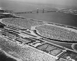
Located on the north side of Rockaway Beach Boulevard extending to Beach Channel Drive is the park's parking lot, which is variously given as being 62 acres (25 ha) or 72 acres (29 ha) in size. The parking lot is the largest individual feature in the park and occupies much of the park site north of the beach. The only entry point to the lot is at its south end in front of the bathhouse, where four toll booths are present. It was built with a capacity of either 9,000 or 14,000 automobiles. At the time of its construction, it was the largest paved parking lot in the world. A grade-level crosswalk to the west of the toll booths, and a pedestrian underpass to the east, lead across the street to the bathhouse. The lot is entirely circumscribed by the access roads to the park, with the roundabout located at its southeast corner, and the interchange with the Marine Park Bridge located near its northwest corner.
The parking lot was managed by the Marine Parkway Authority (which constructed and operated the Marine Parkway Bridge) until 1940, when it was merged with Robert Moses' Triborough Bridge and Tunnel Authority (TBTA). The TBTA operated the parking lot until 1968, when it in turn was merged with the Metropolitan Transportation Authority (MTA)'s Bridges and Tunnels division. In 1974, the entire park and its parking lot was relinquished to the National Park Service. Parking fees collected from Riis Park contributed to the construction of the bridge.
Additional features
At the west end of the park across from Fort Tilden is the park's 18-hole, pitch and putt golf course. It is 26 acres (11 ha) in size. The entrance to the course is from the boardwalk adjacent to the western mall building. The golf course was constructed during the 1936-1937 projects, and opened in 1938. A New York City Fire Department station and a Park Police station are located at the northwest corner of the golf course, on Beach 169th Street across from Fort Tilden. The fire house, Engine 329 and also called the Neponsit Fire Station, was constructed circa 1957 and opened in 1962. At the time it opened, it served the Neponsit, Roxbury and Breezy Point neighborhoods, as well as southern Brooklyn and Floyd Bennett Field. It replaced a local volunteer fire department when it opened. The ladder company of the fire house, Ladder 171, was closed on November 22, 1975 during the city's fiscal crisis.
At the southeast corner of the park just east of the bathhouse and adjacent to Neponsit is Neponsit Beach Hospital, a former children's tuberculosis hospital and later a nursing home. The hospital was built in 1915 on Riis Park property, and closed in September 1998.
The park also contains conventional park recreation including playgrounds and sports fields located in the back beach area. Little league-size baseball fields are located on the west side of the hospital at the east end of the park. Basketball courts are located at the west side of the bathhouse. Farther west near the central mall are handball, paddle ball, and shuffleboard courts. More basketball and handball courts were previously located along the southern edge of the golf course. There are also open grass areas for picnicking and grilling. One of these areas between the bathhouse and mall was previously a lighted softball field. The crescent-shaped plot of land east of the parking lot, 30 acres (12 ha) in size, is undeveloped and consists of open grass and trees. Baseball fields were formerly present on the southern portion of this site.
Beaches
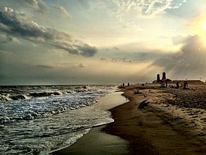
The beaches at Jacob Riis Park consists of 14 bays numbered east-to-west on the Atlantic coast. The main beach occupies the western half of the park, or Bays 6 through 14, at the mouth of the Central Mall. Bays 1 through 5 lie on the eastern half in front of Neponsit Beach Hospital and the park bathhouse. Bay 1 is directly in front of the hospital, while the bathhouse feeds into Bay 4. The main beach features a distinctive crescent shape opening towards the Atlantic Ocean. The eastern half of the beach is much more narrow than the western half. Each bay is separated by reinforced concrete jetties, boulders, and rows of wooden pilings which extend into the ocean. The jetties also stabilize the sand of the beach. Until the 1950s, Bays 1 and 2 were part of the Neponsit Hospital property. Adjacent to the east of Bay 1 is Rockaway Beach, another public beach which stretches from Neponsit to Far Rockaway at the east end of the peninsula. A fence separates the two beaches.
Transportation
Public transport
The Q22 and Q35 local buses serve the park on Rockaway Beach Boulevard. The Q22 runs east-to-west across the Rockaway Peninsula. The Q35 travels between Rockaway Park and Brooklyn via the Marine Parkway Bridge. During summer months (late May to early September) when the park is open, eastbound Q22 buses and all Q35 buses stop at the Riis Park bathhouse. This stop also acts as a drop-off area for passenger cars. Off-season, the closest stop to the park is at Beach 149th Street in front of Neponsit Hospital; westbound Q22s use this stop during summer months. An additional eastbound bus stop is located at the north end of the mall near the bridge. The QM16 express route to Manhattan also operates on Rockaway Beach Boulevard, terminating at the park bathhouse and parking lot. QM16 passengers utilize the parking lot as a park-and-ride facility.
The closest New York City Subway station is the Rockaway Park–Beach 116th Street station on the IND Rockaway Line east of the park, served by the A S trains. The Q22 and Q35 connect to the station. The Q35 also connects to the Flatbush Avenue–Brooklyn College station in Brooklyn.
The New York Water Taxi operates a Rockaway ferry, also called the New York Beach Ferry, from Pier 11/Wall Street in Lower Manhattan, which stops at Riis Landing in front of Fort Tilden on Jamaica Bay. Service began in May 2008. NYC Ferry also operates the Rockaway Ferry route from Pier 11/Wall Street to Beach 108th Street in Rockaway Park. A free shuttle bus travels from the ferry terminal, stopping at Beach 149th Street, the Riis Park bathhouse, and Beach 169th Street.
Road access
Highway access to Riis Park is provided by the Belt Parkway, which runs along the south shore of Brooklyn and Queens. The Belt Parkway connects to the Marine Parkway Bridge via its Flatbush Avenue exit in Marine Park, Brooklyn. Cross Bay Boulevard provides access from central Queens and Broad Channel, leading to both Beach Channel Drive and Rockaway Beach Boulevard. The Riis Park parking lot is a pay-to-park facility during summer months.
Images for kids
-
The construction of the Marine Parkway Bridge, Riis Park (bottom right), and Fort Tilden (bottom left) in 1937. The ferry landings at Riis Park/Fort Tilden and Floyd Bennett Field are also present


