Iselin, New Jersey facts for kids
Quick facts for kids
Iselin, New Jersey
|
|
|---|---|

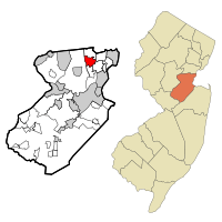
Location of Iselin in Middlesex County highlighted in red (left). Inset map: Location of Middlesex County in New Jersey highlighted in orange (right).
|
|
| Country | |
| State | |
| County | Middlesex |
| Township | Woodbridge |
| Named for | Adrian Georg Iselin |
| Area | |
| • Total | 3.15 sq mi (8.17 km2) |
| • Land | 3.15 sq mi (8.16 km2) |
| • Water | 0.00 sq mi (0.00 km2) 0.03% |
| Elevation | 30 ft (9 m) |
| Population
(2020)
|
|
| • Total | 20,088 |
| • Density | 6,373.1/sq mi (2,460.7/km2) |
| Time zone | UTC−05:00 (Eastern (EST)) |
| • Summer (DST) | UTC−04:00 (Eastern (EDT)) |
| ZIP Code |
08830
|
| Area code(s) | 732/848 |
| FIPS code | 34-34470 |
| GNIS feature ID | 2389973 |
Iselin (/ˈɪzˈlɪn/) is an unincorporated community and census-designated place (CDP) located within Woodbridge Township, in Middlesex County, in the U.S. state of New Jersey. As of the 2010 United States census, Iselin's population was 18,695.
Previously known as Perrytown and Unionville, Iselin received its current name after New York City investment banker and philanthropist Adrian Iselin, who established a finishing school in the 1870s for girls from wealthy New York families there. Iselin additionally subsidized the erection of a new train station which was replaced by a newer station to the south known as Metropark. The largest bordering town of Iselin is Edison.
Contents
Geography
According to the U.S. Census Bureau, Iselin had a total area of 3.190 square miles (8.26 km2), including 3.189 square miles (8.26 km2) of land and 0.001 square miles (0.0026 km2) of water (0.03%).
Downtown area
Iselin's downtown is centered on Little India (also known as "Oak Tree Road"), bound by the Garden State Parkway to the West, and Route 27 (Lincoln Highway) to the East. Once home to a wide array of shops, eateries, services, and complemented by a single-screen 1920s movie palace, the area was in obvious decline in the 1980s. An influx of Asian-Indian immigration beginning in the early 1990s led to the area's revitalization. Formerly vacant stores were tenanted, and additional retail spaces built as the area became known for its high quality Indian food, sweets, clothing (particularly saris), jewelry, music, and other goods.
Metropark

An area known as Metropark, consisting primarily of office parks and large office buildings, lies in the southwestern corner of Iselin and spills over into neighboring Edison. NJ Transit and Amtrak's Metropark station is named for this area.
In addition to a Hilton Hotel (now known as Hotel Woodbridge at Metropark) and the train station, Metropark also features the headquarters of Ansell Limited, Engelhard Corporation (acquired by BASF in 2006) and Eaton Corporation's Filtration Division. Other corporate residents in the area include Siemens, Tata Consultancy Services, Mott MacDonald, Ernst & Young, Mizuho, Wells Fargo, JPMorgan Chase, Accenture, Level 3 Communications, BT Group, UBS, Anthem, Teachers Insurance and Annuity Association of America, Ansell, and EisnerAmper.
Demographics
| Historical population | |||
|---|---|---|---|
| Census | Pop. | %± | |
| 1990 | 16,141 | — | |
| 2000 | 16,698 | 3.5% | |
| 2010 | 18,695 | 12.0% | |
| 2020 | 20,088 | 7.5% | |
| Population sources: 1990-2010 2000 2010 2020 |
|||
2010 census
The 2010 United States census counted 18,695 people, 6,445 households, and 4,892 families in the CDP. The population density was 5,861.5 people per square mile (2,263.1 people/km2). There were 6,718 housing units at an average density of 2,106.3 units per square mile (813.2 units/km2). The racial makeup was 41.47% (7,753) White, 6.72% (1,257) Black or African American, 0.33% (62) Native American, 46.12% (8,623) Asian, 0.00% (0) Pacific Islander, 2.26% (423) from other races, and 3.09% (577) from two or more races. Hispanic or Latino of any race were 7.12% (1,332) of the population.
Of the 6,445 households, 33.2% had children under the age of 18; 62.4% were married couples living together; 9.4% had a female householder with no husband present and 24.1% were non-families. Of all households, 20.7% were made up of individuals and 10.1% had someone living alone who was 65 years of age or older. The average household size was 2.90 and the average family size was 3.39.
21.0% of the population were under the age of 18, 8.0% from 18 to 24, 29.3% from 25 to 44, 27.7% from 45 to 64, and 14.0% who were 65 years of age or older. The median age was 38.5 years. For every 100 females, the population had 95.7 males. For every 100 females ages 18 and older there were 94.8 males.
South Asian community
Iselin hosts one of the region's main centers of Indian American cultural diversity. The growing Little India is a South Asian-focused commercial strip in Middlesex County, the U.S. county with the highest concentration of Asian Indians. The Oak Tree Road strip runs for about one-and-a-half miles through Iselin and neighboring Edison Township, near the area's sprawling Chinatown and Koreatown, running along New Jersey Route 27. The zone is the largest and most diverse South Asian cultural hub in the United States. In Middlesex County, election ballots are printed in English, Spanish, Gujarati, Hindi, and Punjabi. According to the 2017 American Community Survey, 42.6% of Iselin residents identified themselves as being Indian American, the highest percentage for any census-designated place in the United States.
Education
Iselin public school students attend the schools of the Woodbridge Township School District. Indiana Avenue School #18, Kennedy Park School #24, Robert Mascenik School #26, and Oak Tree Road School #29 are located in Iselin as well as Iselin Middle School and John F. Kennedy Memorial High School.
When it opened in 2018, Oak Tree Road School #29 was the first new public school in Woodbridge in nearly 50 years, although the building was formerly occupied by the St. Cecelia's Church parish school (affiliated with the Roman Catholic Diocese of Metuchen).
Notable people
People who were born in, residents of, or otherwise closely associated with Iselin include:
- Tom DeSanto (born 1968), film producer and screenwriter best known for his work with long-time friend Bryan Singer, especially with his contributions to the first two X-Men movies
- Robbie E (born 1983), professional wrestler with Impact Wrestling on POP TV
- Chris Smith (born 1953), U.S. Representative for New Jersey's 4th congressional district since 1981
See also
 In Spanish: Iselin (Nueva Jersey) para niños


