
Image: Location map of Washington County, Indiana

Size of this PNG preview of this SVG file: 600 × 600 pixels. Other resolution: 240 × 240 pixels.
Original image (SVG file, nominally 768 × 768 pixels, file size: 241 KB)
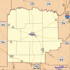
Description: This is a map of Washington County, Indiana, USA which includes incorporated settlements, township borders, and major highways.
Title: Location map of Washington County, Indiana
Credit: My own work, using custom-written MapScript applications with United States Census Bureau data
Author: Omnedon
Usage Terms: Public domain
License: Public domain
Attribution Required?: No
Image usage
The following 38 pages link to this image:
- Bartle, Indiana
- Beck's Mill
- Brimstone Corners, Indiana
- Bunker Hill, Washington County, Indiana
- Canton, Indiana
- Claysville, Indiana
- Daisy Hill, Indiana
- Fair Acres, Indiana
- Fairview, Washington County, Indiana
- Farabee, Indiana
- Fayetteville, Washington County, Indiana
- Georgetown, Washington County, Indiana
- Gooseport, Indiana
- Haleysburg, Indiana
- Harristown, Indiana
- Highland, Washington County, Indiana
- Hitchcock, Indiana
- John Hay Center
- Kossuth, Indiana
- Martin Heights, Indiana
- Martinsburg, Indiana
- McCol Place, Indiana
- McKinley, Indiana
- Millport, Indiana
- Mount Carmel, Washington County, Indiana
- New Liberty, Indiana
- New Philadelphia, Indiana
- New Salem, Washington County, Indiana
- Old Pekin, Indiana
- Organ Springs, Indiana
- Plattsburg, Indiana
- Prowsville, Indiana
- Pumpkin Center, Washington County, Indiana
- Rosebud, Washington County, Indiana
- Rush Creek Valley, Indiana
- Shorts Corner, Indiana
- Smedley, Indiana
- South Boston, Indiana

All content from Kiddle encyclopedia articles (including the article images and facts) can be freely used under Attribution-ShareAlike license, unless stated otherwise.