Rosebud, Washington County, Indiana facts for kids
Quick facts for kids
Rosebud
|
|
|---|---|

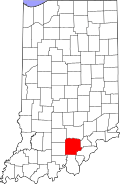
Washington County's location in Indiana
|
|
| Country | United States |
| State | Indiana |
| County | Washington |
| Township | Howard |
| Elevation | 774 ft (236 m) |
| Time zone | UTC-5 (Eastern (EST)) |
| • Summer (DST) | UTC-4 (EDT) |
| ZIP code |
47167
|
| Area code(s) | 812, 930 |
| GNIS feature ID | 442302 |
Rosebud is an unincorporated community in Howard Township, Washington County, in the U.S. state of Indiana.
History
A post office was established at Rosebud in 1898, and remained in operation until 1901.
Geography
Rosebud is located at 38°31′40″N 86°12′43″W / 38.52778°N 86.21194°W.

All content from Kiddle encyclopedia articles (including the article images and facts) can be freely used under Attribution-ShareAlike license, unless stated otherwise. Cite this article:
Rosebud, Washington County, Indiana Facts for Kids. Kiddle Encyclopedia.

