
Image: Limes1

Size of this preview: 800 × 577 pixels. Other resolutions: 320 × 231 pixels | 3,277 × 2,362 pixels.
Original image (3,277 × 2,362 pixels, file size: 679 KB, MIME type: image/png)
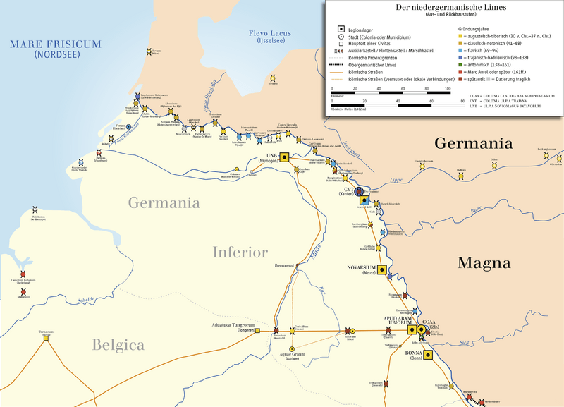
Description: Map of Limes The Lower (Northern) Germanic Limes,
Title: Limes1
Credit: Eigenes Werk (own work); Source of Information: Putzger – Historischer Weltatlas, 89. Auflage, 1965; Westermanns Großer Atlas zur Weltgeschichte, 1978; Hugo Thoen (Red.): De Romeinen langs de Vlaamse Kust. Gemeentekrediet, Koksijde en Oudenburg 1987
Author: Ziegelbrenner
Usage Terms: Creative Commons Attribution-Share Alike 3.0
License: CC BY-SA 3.0
License Link: http://creativecommons.org/licenses/by-sa/3.0
Attribution Required?: Yes
Image usage
The following 3 pages link to this image:

All content from Kiddle encyclopedia articles (including the article images and facts) can be freely used under Attribution-ShareAlike license, unless stated otherwise.