
Image: Hawaiianislandchain USGS
No higher resolution available.
Hawaiianislandchain_USGS.png (569 × 289 pixels, file size: 7 KB, MIME type: image/png)
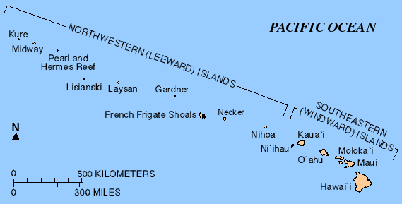
Description: Map of the Hawaiian Islands — a chain of volcanoes that stretches about 2,700 kilometres (1,700 mi) in a northwest direction, from the Island of Hawai'i and other Windward/Southeastern Main Hawaiian Islands, to the Leeward Northwestern Hawaiian Islands (Honolulu County).
Title: Hawaiianislandchain USGS
Credit: http://hvo.wr.usgs.gov/volcanoes/
Author: United States Geological Survey (USGS)
Usage Terms: Public domain
License: Public domain
Attribution Required?: No
Image usage

All content from Kiddle encyclopedia articles (including the article images and facts) can be freely used under Attribution-ShareAlike license, unless stated otherwise.