
Image: Aquae planrome3

Size of this preview: 789 × 599 pixels. Other resolutions: 316 × 240 pixels | 1,411 × 1,072 pixels.
Original image (1,411 × 1,072 pixels, file size: 314 KB, MIME type: image/png)
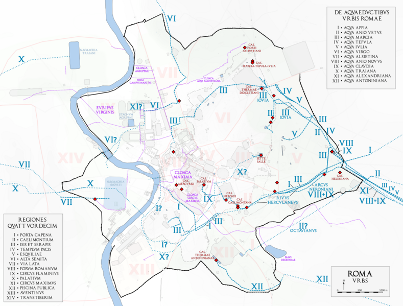
Description: Map of ancient Rome showing the water distribution system via the aqueducts and castella and the sewage system from the foundation of the city until the fourth century AD. Map based after Rodolfo Lanciani, Forma Urbis, completed and corrected with the most recent archaeological proposals and discoveries.
Title: Aquae planrome3
Credit: Own work
Author: Cassius Ahenobarbus
Usage Terms: Creative Commons Attribution-Share Alike 4.0
License: CC BY-SA 4.0
License Link: https://creativecommons.org/licenses/by-sa/4.0
Attribution Required?: Yes
Image usage
The following page links to this image:

All content from Kiddle encyclopedia articles (including the article images and facts) can be freely used under Attribution-ShareAlike license, unless stated otherwise.