Ichihara, Chiba facts for kids
Quick facts for kids
Ichihara
市原市
|
|||||||||||||
|---|---|---|---|---|---|---|---|---|---|---|---|---|---|

|
|||||||||||||
|
|||||||||||||

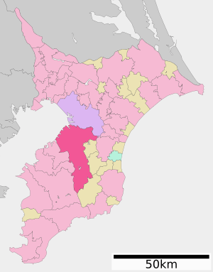
Location of Ichihara in Chiba Prefecture
|
|||||||||||||
| Country | Japan | ||||||||||||
| Region | Kantō | ||||||||||||
| Prefecture | Chiba | ||||||||||||
| First official recorded | mid 3rd century (official) | ||||||||||||
| Goi town settled | May 20, 1891 | ||||||||||||
| Ichihara town settled | March 31, 1955 | ||||||||||||
| Both town merged and city settled | May 1, 1963 | ||||||||||||
| Area | |||||||||||||
| • Total | 368.17 km2 (142.15 sq mi) | ||||||||||||
| Population
(December 1, 2020)
|
|||||||||||||
| • Total | 274,117 | ||||||||||||
| • Density | 744.539/km2 (1,928.348/sq mi) | ||||||||||||
| Time zone | UTC+9 (Japan Standard Time) | ||||||||||||
| Phone number | 0436-22-1111 | ||||||||||||
| Address | 1-1-1 Kokubunjidai Chūō, Ichihara-shi, Chiba-ken 290-8501 | ||||||||||||
| Climate | Cfa | ||||||||||||
|
|||||||||||||
Ichihara (市原市, Ichihara-shi) is a city, located in Chiba Prefecture, Japan. As of 1 December 2020[update], the city had an estimated population of 274,117 in 128,316 households and a population density of 240 persons per km2. The total area of the city is 368.20 square kilometres (142.16 sq mi). The city is home, together with the city of Chiba, to the JEF United football club. The whole city is also parts of Greater Tokyo Area.
Contents
Geography
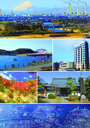
Ichihara is located in the western part of the Bōsō Peninsula, and geographically is the largest of Chiba Prefecture's cities and towns. The south is a mountainous area connected to the Boso hills. The highly industrialized northern part of the city faces Tokyo Bay. Ichihara, dense in housing developments, serves as a satellite town of Tokyo and Chiba City.
Surrounding municipalities
Chiba Prefecture
Climate
Ichihara has a humid subtropical climate (Köppen Cfa) characterized by warm summers and cool winters with light to no snowfall. The average annual temperature in Ichihara is 15.1 °C (59.2 °F). The average annual rainfall is 1,673.1 mm (65.87 in) with October as the wettest month. The temperatures are highest on average in August, at around 26.5 °C (79.7 °F), and lowest in January, at around 4.1 °C (39.4 °F).
| Climate data for Ichihara (1991−2020 normals, extremes 1978−present) | |||||||||||||
|---|---|---|---|---|---|---|---|---|---|---|---|---|---|
| Month | Jan | Feb | Mar | Apr | May | Jun | Jul | Aug | Sep | Oct | Nov | Dec | Year |
| Record high °C (°F) | 21.1 (70.0) |
24.6 (76.3) |
27.5 (81.5) |
30.0 (86.0) |
35.7 (96.3) |
36.5 (97.7) |
40.2 (104.4) |
39.2 (102.6) |
37.5 (99.5) |
33.8 (92.8) |
26.4 (79.5) |
24.3 (75.7) |
40.2 (104.4) |
| Mean daily maximum °C (°F) | 10.5 (50.9) |
11.3 (52.3) |
14.4 (57.9) |
19.5 (67.1) |
23.7 (74.7) |
26.1 (79.0) |
30.3 (86.5) |
31.8 (89.2) |
27.7 (81.9) |
22.4 (72.3) |
17.6 (63.7) |
12.9 (55.2) |
20.7 (69.2) |
| Daily mean °C (°F) | 4.1 (39.4) |
5.2 (41.4) |
8.6 (47.5) |
13.7 (56.7) |
18.2 (64.8) |
21.3 (70.3) |
25.4 (77.7) |
26.5 (79.7) |
22.9 (73.2) |
17.3 (63.1) |
11.8 (53.2) |
6.6 (43.9) |
15.1 (59.2) |
| Mean daily minimum °C (°F) | −1.5 (29.3) |
−0.6 (30.9) |
2.9 (37.2) |
8.0 (46.4) |
13.1 (55.6) |
17.3 (63.1) |
21.5 (70.7) |
22.5 (72.5) |
19.0 (66.2) |
13.0 (55.4) |
6.6 (43.9) |
1.1 (34.0) |
10.2 (50.4) |
| Record low °C (°F) | −8.0 (17.6) |
−9.2 (15.4) |
−5.7 (21.7) |
−2.4 (27.7) |
3.3 (37.9) |
8.0 (46.4) |
11.7 (53.1) |
14.3 (57.7) |
7.7 (45.9) |
1.8 (35.2) |
−3.1 (26.4) |
−7.0 (19.4) |
−9.2 (15.4) |
| Average precipitation mm (inches) | 82.4 (3.24) |
74.0 (2.91) |
138.0 (5.43) |
132.5 (5.22) |
130.4 (5.13) |
170.6 (6.72) |
151.8 (5.98) |
114.8 (4.52) |
237.1 (9.33) |
256.8 (10.11) |
113.9 (4.48) |
70.9 (2.79) |
1,673.1 (65.87) |
| Average precipitation days (≥ 1.0 mm) | 6.3 | 6.9 | 11.2 | 10.5 | 10.4 | 11.9 | 10.0 | 7.3 | 11.8 | 12.0 | 9.0 | 6.5 | 113.8 |
| Mean monthly sunshine hours | 182.0 | 158.4 | 160.8 | 172.1 | 170.1 | 117.3 | 159.2 | 192.0 | 135.7 | 126.4 | 142.2 | 162.9 | 1,879.2 |
| Source: Japan Meteorological Agency | |||||||||||||
History
The area of modern Ichihara is the center of ancient Kazusa province. The ruins of the Nara period Kazusa Kokubun-ji provincial temple have been found within the borders of Ichihara, although the exact location of the Nara-period provincial capital remains uncertain. During the Sengoku period, the area was contested between the Chiba clan to the north, and the Satomi clan to the south. During the Edo period, the area was divided between Goi Domain, Tsurumaki Domain and large areas of tenryō territory controlled directly by the Tokugawa shogunate and administered by various hatamoto.
Timeline
- During the Meiji period, the area was reorganized into 171 villages under Ichihara District, Chiba Prefecture with the establishment of the modern municipalities system.
- In September 1923, the city was affected by Great Kanto earthquake.
- By 1945, these villages had been consolidated into five towns and 16 villages.
- Through further consolidation and mergers, the city of Ichihara was founded on May 1, 1963.
- On 1 October 1967, the neighboring town of Nansō, and village of Kamo were merged into Ichihara.
- On 11 March 2011, the city was struck by earthquake and tsunami and the subsequent Fukushima nuclear disaster, which causes of the natural gas storage tanks at the Cosmo oil refinery in Ichihara were set on fire by the earthquake.
Demographics
Per Japanese census data, the population of Ichihara has recently plateaued after several decades of strong growth.
| Historical population | ||
|---|---|---|
| Year | Pop. | ±% |
| 1920 | 68,825 | — |
| 1930 | 71,287 | +3.6% |
| 1940 | 75,069 | +5.3% |
| 1950 | 98,375 | +31.0% |
| 1960 | 94,309 | −4.1% |
| 1970 | 155,852 | +65.3% |
| 1980 | 216,394 | +38.8% |
| 1990 | 257,716 | +19.1% |
| 2000 | 278,218 | +8.0% |
| 2010 | 280,416 | +0.8% |
| 2020 | 269,524 | −3.9% |
Economy
The city's economy is fueled by a large industrial complex overlooking Tokyo Bay. It contains the largest number of oil refineries in Japan, as well as power, petrochemical and shipbuilding companies.
Education
- Teikyo Heisei University
- Ichihara has 41 public elementary schools and 21 public middle schools operated by the city government, and six public high schools operated by the Chiba Prefectural Board of Education. There are also one private elementary school and two private high schools. The prefecture also operates one special education school for the handicapped.
Transportation
Railway
![]() JR East – Uchibō Line
JR East – Uchibō Line
- Yawatajuku - Goi - Anegasaki
![]() Keisei Electric Railway – Keisei Chihara Line
Keisei Electric Railway – Keisei Chihara Line
- Chiharadai
![]() Kominato Railway – Kominato Line
Kominato Railway – Kominato Line
- Goi - Kazusa-Murakami - Amaariki - Kazusa-Mitsumata - Kazusa-Yamada - Kōfūdai - Umatate - Kazusa-Ushiku - Kazusa-Kawama - Kazusa-Tsurumai - Kazusa-Kubo - Takataki - Satomi - Itabu - Tsukizaki - Kazusa-Ōkubo - Yōrōkeikoku
Highway
 Ken-Ō Expressway
 Tateyama Expressway
 National Route 16
 National Route 297
 National Route 409
Sister cities
 Mobile, Alabama, United States, since November 10, 1993
Notable people from Ichihara
- Chiaki, Singer
- Neko Hiroshi, Marathon Runner
- Katsushige Kawashima, Boxer
- Hirotoshi Ishii, Baseball Player
- Kohei Kudo, Soccer Player
- Suzuran Yamauchi, Tarento
See also
 In Spanish: Ichihara (Chiba) para niños


