Hurricane Helene facts for kids
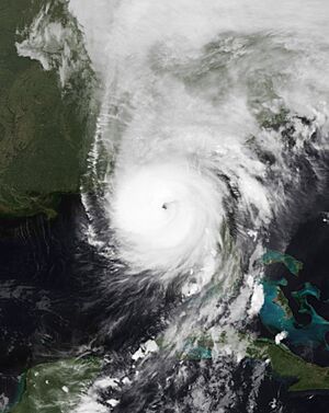
Helene at peak intensity just prior to landfall in the Big Bend region of Florida late on September 26
|
|
| Meteorological history | |
|---|---|
| Formed | September 24, 2024 |
| Extratropical | September 27, 2024 |
| Dissipated | September 29, 2024 |
| Category 4 tropical cyclone | |
| 1-minute sustained (SSHWS/NWS) | |
| Highest winds | 140 mph (220 km/h) |
| Lowest pressure | 938 mbar (hPa); 27.70 inHg |
| Overall effects | |
| Fatalities | ≥113 |
| Missing | ≥1,073 |
| Damage | ≥$20 billion (2024 USD) |
| Areas affected | Yucatán Peninsula, Honduras, Cayman Islands, Cuba, Southeastern United States (especially Florida, the Carolinas and Georgia, but also including Alabama, Tennessee, Kentucky, Virginia and West Virginia), Midwestern United States (Illinois, Indiana, Ohio) |
|
Part of the 2024 Atlantic hurricane season |
|
Hurricane Helene ( HEHL-een) was a large, catastrophic, and fast-moving tropical cyclone that was the strongest on record to strike the Big Bend region of Florida. The eighth named storm, fifth hurricane, and second major hurricane of the 2024 Atlantic hurricane season, Helene developed from a broad area of low pressure, the Central American gyre, in the Western Caribbean Sea in late September that the National Hurricane Center (NHC) first began watching on September 17. By September 24, the disturbance had consolidated enough to become a tropical storm as it approached the Yucatán Peninsula, receiving the name Helene. Favorable conditions led to the cyclone's gradual intensification, and it became a hurricane early on September 25. More pronounced and eventually rapid intensification ensued as Helene traversed the Gulf of Mexico the following day, reaching Category 4 intensity on the evening of September 26. Late on September 26, Helene made landfall at peak intensity in the Big Bend region of Florida, near the city of Perry, with maximum sustained winds of 140 mph (220 km/h). Helene would quickly weaken as it moved quickly inland before degenerating to a post-tropical cyclone over Tennessee on September 27. The storm then stalled over the state before dissipating on September 29.
In advance of Helene's expected landfall, the governors of Florida and Georgia declared states of emergency due to the significant impacts expected, including very high storm surge along the coast and hurricane-force gusts as far inland as Atlanta. Helene also caused catastrophic rainfall-triggered flooding, particularly in western North Carolina and eastern Tennessee. Hurricane warnings also extended further inland. As of September 29, a total of 113 deaths have been attributed to Helene with an additional 1,073 people missing.
Contents
Meteorological history
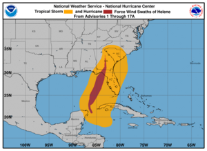
On September 17, the National Hurricane Center (NHC) highlighted the potential for tropical cyclogenesis in the western Caribbean Sea. Conditions conducive for development of a tropical cyclone resulted from the interaction of the Central American gyre—a broad monsoon low pressure system—and the Madden–Julian Oscillation, which reinforced synoptic scale cyclonic flow extending from the eastern Pacific Ocean to the western Caribbean Sea. Several days later, on September 22, a broad low-pressure area developed within the western Caribbean. As the system traversed an environment conducive for tropical cyclone development, showers and thunderstorms associated with the disturbance gradually consolidated. Due to the system's imminent threat to land, it was designated Potential Tropical Cyclone Nine on September 23. The next day, Air Force Reserve Hurricane Hunters aircraft found that the system was producing flight-level winds of 52 mph (84 km/h) and had developed a better-defined center; the NHC accordingly upgraded the system to Tropical Storm Helene at 15:00 UTC. The system continued strengthening, with NOAA and Air Force Reserve Hurricane Hunters finding that Helene's maximum winds had increased to 80 mph (130 km/h). As a result, NHC upgraded the system to a hurricane by 15:00 UTC on September 25 as it began to enter the Gulf of Mexico while turning to the north. An upper-level trough to its west and a ridge of high pressure located off the Southeastern United States both served to steer the cyclone towards the U.S. Gulf Coast. Helene was a very large system, with the NHC noting in multiple forecast discussions that the forecast storm radii were "at the 90th percentile of hurricane size at similar latitudes".

After remaining steady in intensity for a while due to its broad size and some entrainment of drier air to its west, Helene began its rapid intensification early on the morning of September 26 — aided by low mid-level wind shear, high relative humidity values and sea surface temperatures (SSTs) exceeding 30 °C (86 °F) near the Loop Current — as an increasingly well-defined eye developed, reaching Category 2 intensity at 12:00 UTC. Quickly strengthening, by 18:25 UTC Helene was found to have become a major hurricane by Hurricane Hunters, and four hours later, a Category 4 hurricane. The hurricane attained its peak intensity later that night with maximum sustained wind of 140 mph (220 km/h) and a minimum barometric pressure of 938 millibars (27.70 inHg) at 3:10 UTC on September 27 as it made landfall east of the center of the Aucilla River about 10 miles (16 km) west-southwest of Perry, Florida, becoming the strongest hurricane to strike Florida's Big Bend region.
Rapid weakening occurred as the storm tracked inland, and by the time it reached Georgia at 05:00 UTC the next day, it had weakened into a Category 2 hurricane. Weakening further, it became a tropical storm over east central Georgia a few hours later.
Preparations
Mexico
Tropical storm warnings were issued on September 24 for the eastern Yucatan Peninsula. Parts of Quintana Roo and Yucatán were placed under a blue alert, indicating indirect impacts. It was later raised to red alert, maximum danger. Cruise ship arrivals in the former state's ports were canceled for September 24 and 25. Tren Maya was also closed. On Isla Mujeres, two shelters were opened. Evacuations were carried out in vulnerable areas. Visitors of Isla Holbox were offered a ferry ride off the island with no cost. Classes were suspended in Quintana Roo.
Caribbean
Cayman Islands
The Cayman Islands were placed under a tropical storm warning on September 24. The Cayman Islands' Red Cross shelter opened in preparation for the storm; nobody used it. Sandbagging sites opened on Grand Cayman and Cayman Brac. Due to the threat of heavy rainfall, schools in the Cayman Islands were closed on September 23. Charles Kirkconnell International Airport and Owen Roberts International Airport were closed ahead of Helene's arrival. The Cayman Islands Regiment was deployed ahead of the system to help with preparation and distribute sandbags. Additionally, a small craft warning was issued for the islands on September 23, with a marine advisory issued the next day. The tropical storm warning was canceled the next day.
Cuba
Tropical storm warnings and hurricane watches were issued for western Cuba. Medical brigades were prepared for flood-prone areas; as heavy rain began to fall, schools and ports were closed, and fishing boats were called in. Due to adverse weather conditions caused by Helene, the Provincial Transport Company of Havana suspended ferry services in Regla. Additionally, the Maritime Administration of Cuba suspended navigation in the Gulf of Batabanó.
United States
Amtrak modified or canceled several of its southeastern train routes between September 27—28 because of the storm.
Florida

Hurricane warnings were issued for the Big Bend area of Florida, with nearly all of Florida, except the westernmost part of the Florida panhandle, put under a tropical storm warning. In addition, on the evening of September 26, an extreme wind warning was issued for the east part of the Florida Panhandle, the first since Hurricane Idalia. On September 23, Governor Ron DeSantis issued a state of emergency for 41 Florida counties. The next day, this was expanded to 61 counties. U.S. President Joe Biden authorized a federal disaster declaration for 61 counties across Florida. Locally, Volusia County issued a state of emergency. Several sandbagging sites opened up across the state. On September 24, several state parks were closed: four of them in Franklin County, two in Gulf County, and one in Gadsen County.
In the Tampa Bay area, officials announced that schools would be closed ahead of the storm. A college football game between Florida A&M University and Alabama A&M University, which was scheduled for the weekend of September 28–29, would be postponed until November 29 due to the storm. At Florida State College at Jacksonville, classes and activities at the campus were canceled for two days. The SpaceX Crew-9 mission, which would have launched from the Cape Canaveral Space Force Station on September 26, was delayed to September 28 due to the storm. The Central Florida Zoo and Botanical Gardens planned to close on September 26 and canceled events on that date. Mickey's Not-So-Scary Halloween Party was canceled for Helene.Halloween Horror Nights was also cancelled. The universities of Central Florida, Embry–Riddle Aeronautical, Florida, Florida A&M, Florida Atlantic, Florida Gulf Coast, Florida State, Keiser, Lynn, North Florida, South Florida, and Stetson announced closures of their campuses and suspended academic operations. Leon County opened up schools to be used as shelters.
On September 24, Citrus County issues mandatory evacuations for zone A, which includes coastal areas in the communities of Crystal River and Homosassa. In Wakulla County, a mandatory evacuation for all residents and visitors, while in Hernando County, mandatory evacuations were ordered for anyone west of U.S. Route 19 and all residents in coastal or low-lying areas and those living in manufactured homes. Two prisons in Wakulla Country holding a combined 2,500 inmates were not evacuated despite the evacuation order issued to residents. Gulf County issued mandatory evacuations for all visitors. Elsewhere, in Charlotte County and Franklin County, mandatory evacuations were issued for barrier islands, low-lying and flood-prone areas, manufactured homes, and homes that did not meet building codes. In Sarasota County, officials issued an evacuation order for Level A and manufactured home communities on September 25.
Busch Gardens Tampa Bay, St. Pete–Clearwater International Airport, and Tampa International Airport were closed on September 26. Further north, Tallahassee International Airport was closed the same day.
Georgia
The coast of Georgia was placed under tropical storm warnings while Southwest Georgia was under a hurricane warning, with the warnings later extending to the entire state. In addition, on the night of September 26, an extreme wind warning was issued for portions of South Georgia, including Valdosta. On September 24, in preparation for Helene, officials in the counties of Bryan, Candler, and Chatham began mobilizing emergency response centers. Colquitt, Thomas, and Decatur counties opened shelters. That same day, Governor Brian Kemp issued a state of emergency for Georgia since Helene was expected to track into the state. In Thomas County, the Public Works Department began providing sandbags due to the storm.
On September 25, schools were closed in the counties of Bibb and Twiggs. Many schools in the Atlanta metro area cancelled instruction for September 26 and 27, such as Atlanta Public Schools, with some counties moving students and non-essential workers online. Elsewhere, in Clayton County schools, indoor and outdoor athletic events were canceled. The Cumberland Island National Seashore and Fort Pulaski National Monument closed on September 25 in preparation for the hurricane. The Atlanta Braves postponed the remaining two games in a series against the New York Mets to September 30 in a doubleheader. Curfews were implemented by several localities on September 26. Emory University moved classes online for September 26 and 27.
South Carolina
The entirety of South Carolina was placed under tropical storm warning. Governor Henry McMaster issued a state of emergency for South Carolina. Congaree National Park was closed September 26 through September 27 due to the hurricane.
North Carolina
Western North Carolina was placed under tropical storm warnings. Governor Roy Cooper declared a state of emergency for North Carolina. Both Gorges State Park and Mount Mitchell State Park were closed due to the storm, with a shutdown also occurring on the Blue Ridge Parkway.
Other states
Some parts of Indiana and Ohio were placed under high wind warning or wind advisory alerts, as a result of remnants of the hurricane producing wind speeds of at least 10–35 mph (16–56 km/h) as well as potential wind gusts up to 50 mph (80 km/h).
In Alabama, Henry and Houston Counties were placed under a hurricane warning. Several eastern counties were also placed under tropical storm warning. Several school districts in Alabama either canceled school or released early in preparation for Helene. A state of emergency was approved for the state by Joe Biden. In Louisville, Kentucky, a music festival, Louder Than Life, canceled their Friday shows due to strong winds.
In Virginia, Governor Glenn Youngkin issued a state of emergency. Virginia Task Force 1 along with Maryland Task Force 1 were deployed to Hurricane Helene.
Impact
Honduras
Honduras experienced heavy rains as a result of the Central American gyre which preceded Helene. As a result, the Goascorán River brought flooding to nearby communities located in low-lying areas through Valle and Choluteca departments, reaching a level over .48 feet (0.15 m). A state of emergency was issued in San Marcos de Colón, Choluteca, due to overall damage caused by the storm. Near 30 homes were estimated to be affected in El Cubulero, Alianza, Valle. 120 families were affected in the coastal town of Marcovia, Choluteca, due to high waves onshore; at least one home was destroyed. Heavy rainfall left communities isolated and 50 people sheltered in El Paraíso due to severe floods.
Mexico

The region around Cancún received 240 millimetres (9.4 in) of rain. Over 120,000 customers, 14% of all Comisión Federal de Electricidad customers, lost power in Quintana Roo. Extreme flooding covering much of Isla Mujeres occurred. The island also experienced wind gusts up to 69 miles per hour (111 km/h). Cancún and Cozumel saw very rough surf, breaking the seawall in Cozumel and increasing beach erosion in Cancún. Flights at Cozumel International Airport were delayed while Cancún International Airport saw nearly 100 cancellations or delays. Only minor delays occurred at Merida Airport. The companies most affected by Helene were Viva Aerobus, Volaris, and Aeromexico. Trees fell and roofs were damaged across the Yucatan Peninsula.
A gas explosion occurred in Cancún during Helene, but no fatalities were reported in Mexico.
Caribbean
Cayman Islands
Over 10 inches (250 mm) of rain fell onto the Cayman Islands. Heavy rainfall and large waves began affecting the Cayman Islands on September 24. Roads in George Town were flooded as rainfall produced by the storm caused 14 power outages, affecting 118 customers across Grand Cayman. The government began planning to buy land to aid in storm water management. After Helene had passed, Grand Cayman was impacted by 5–7 foot (1.5–2.1 m) waves on September 26.
Cuba
In Cuba, heavy rainfall occurred, with peak accumulations of 218.4 mm (8.60 in) recorded in Presa Herradura and 186.8 mm (7.35 in) in Palacios. Elsewhere, Punta del Este and Isla de la Juventud received 101 mm (4.0 in), Paso Real de San Diego received 78 mm (3.1 in), Pinar del Río received 72 mm (2.8 in), and Isabel Rubio received 70 mm (2.8 in). In Pinar del Río Province, 17 of the province's 24 reservoirs overflowed. Elsewhere, in El Palenque, road access was cut off due to flooding caused by Helene. Helene's winds caused a failure in the power lines which feed the Guanito transmitter, causing most of the territory, especially San Juan and Martínez, Guane, Mantua, and Minas de Matahambre, to suffer blackouts. Gale-force winds were recorded in the provinces of Isla de la Juventud and Pinar del Río. In total, around 70,000 customers experienced power outages in Pinar del Rio, with another 160,000 residents affected in Artemisa.
In Havana, one person was injured after an uninhabited building collapsed due to heavy rains and two landslides occurred. Intense rainfall caused the Cuyaguateje River to rise rapidly, causing flooding in parts of Pinar del Río on September 26. Flooding also occurred in Mayabeque Province, primarily in the municipalities of Batabanó, Melena del Sur, and San Nicolás de Bari.
United States
| State | Deaths | Damage (US$) | Ref |
|---|---|---|---|
| Florida | 13 | Unknown | |
| Georgia | 23 | Unknown | |
| South Carolina | 27 | Unknown | |
| North Carolina | ≥46 | Unknown | |
| Tennessee | 2 | Unknown | |
| Virginia | 2 | Unknown | |
| West Virginia | 0 | Unknown | |
| Kentucky | 0 | Unknown | |
| Ohio | 0 | Unknown | |
| Indiana | 0 | Unknown | |
| Illinois | 0 | Unknown | |
| Total | ≥113 | Unknown |

Initial estimates guessed insured losses could reach US$3–6 billion, according to reinsurance broker Gallagher Re. with AM Best estimating more than US$5 billion. However, newer estimates by Moody's Analytics estimated that the damages could reach US$20–34 billion. AccuWeather estimated that the total damage and economic loss could cost anywhere from US$95–110 billion.
Florida
By the morning of September 26, 2024 thousands in the Tampa Bay Area were experiencing power outages. Wind gusts reached 64 mph (103 km/h) in Fort Lauderdale and 67 mph (108 km/h) in Naples. Storm surges in Steinhatchee reached 9.63 feet (2.94 m). Key West experienced storm surge of 1 to 3 feet (0.30 to 0.91 m). Storm surges reached 9.5 feet (2.9 m) in Steinhatchee before the storm surge meter stopped recording, with heights reaching 7.18 feet (2.19 m) in Tampa. About 1.3 million people lost power in the state. The Stan Gober Memorial Bridge shut down due to flooding, and all sporting events in Collier County on September 27 were cancelled.
Multiple Waffle Houses in Tallahassee and one in Crawfordville shut down, raising the Waffle House Index to red which indicates the possibility of severe damage to the restaurant. Orlando International Airport, remaining open, saw 65 cancellations on September 26.
Twelve fatalities have been reported in Florida, including at least nine in Pinellas County. Pasco County's Sheriff rescued around 200 people in water emergencies. In Citrus County, over 100 people and 50 pets were rescued after ten feet of storm surge hit the area.
Multiple buildings caught fire in Clearwater Beach following storm surge. According to Taylor County sheriff Wayne Padgett, 90% of homes in Keaton Beach was destroyed. At least 24 businesses and 70 homes were also destroyed in Gulfport.
Despite not directly affecting Volusia County, gale-force gusts downed several trees, with a peak of 53 mph (85 km/h) in the county. More than 9,000 residents were without power in as of September 27. In Edgewater, a carport blew over while a tree fell through the roof of a mobile home in the Sea Horse Mobile Home Park. In Seminole County, which was effected only by outer bands of the storm, a large tree fell into a duplex style home through the roof. Seminole County saw 2,427 people without power, while neighboring Orange County saw 4,476 customers without power. Elsewhere, in Flagler County, the highest gusts recorded were in Marineland, which had winds of 63 mph (101 km/h). Approximately 20,000 residents lost power from September 26 and 27. A tree fell through a roof at a home in Palm Coast, while in Palm Beach, a "small scarp" received a local surge of 18 in (460 mm).
Georgia
In Atlanta, the National Weather Service in Peachtree City issued the city's first ever flash flood emergency due to Atlanta having its heaviest 3-day rainfall totals in 104 years. Rainfall totals over 48 hours in the city reached 11.12 in (282 mm), the most the city has seen in 48 hours since recordkeeping began in 1878. About 25 people had to be rescued from floods in Atlanta. Fox Weatherman Bob Van Dillen is caught on live television saving a women from her Toyota RAV4 with flood waters up to the windows. Localized urban flooding was also reported on multiple interstates like I-285, I-85, I-75 and many other interstate systems encompassing Atlanta. More of the significant flooded occurred in Buckhead due to the overflowing of the Peachtree Creek which flooded multiple surrounding apartment complexes. Other flooding also occurred in areas around Metro Atlanta. The Chattahoochee River overflowed its banks in multiple areas around Fulton County, Georgia and in downstream counties which prompted a water rescue in Coweta County. In Columbus, a daily rainfall record was set with around 4 in (100 mm) of rain on September 26. Wind gust in the city reached 38 mph (61 km/h), with gusts reaching 59 mph (95 km/h) in Macon and 80 mph (130 km/h) in Augusta. Rabun County officials ordered the evacuation of people living below a dam at Lake Rabun after officials were forced to open a third floodgate, inundating several roads and trapping people in their communities in the southern part of the county. Four homes were destroyed by falling trees in White County and Habersham County, but no injuries were reported. The Hiwassee River in Towns County crested at over ten feet, just one foot below the record, and flooded pastures and a campground.
Over a million customers lost electric power in the state during Helene due to trees falling on power lines across the state and high wind speeds. There are over over 400,000 people still without electricity as of September 29. At least 115 structures in Valdosta were heavily damaged.
Injuries and deaths were reported throughout the state.
JD Vance canceled two events for the 2024 Trump–Vance campaign scheduled in Georgia.
North Carolina
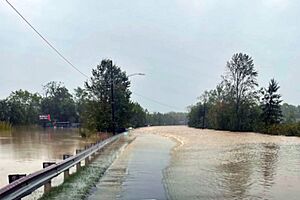
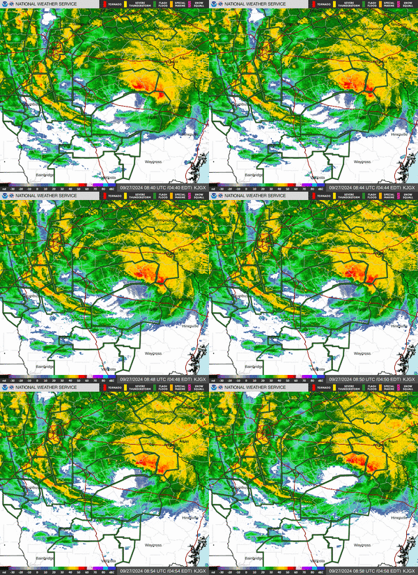
Forty-six people were killed in North Carolina, while about 1,000 more were left unaccounted for in the state. At least 879,000 customers in the state lost power. In Charlotte, high winds from Helene caused a tree to fall onto a residence, killing one person and seriously injuring another. Residents living downstream of Lake Lure were ordered to evacuate as the Lake Lure Dam was overtopped by water and imminent failure was expected. Lake Lure Dam was later evaluated with no imminent failure expected, although erosion on both sides of the dam and compromisation of the structural supports were reported. A brief, but intense low-end EF3 tornado impacted US 301, damaging 14 buildings and injuring 15 people, including four critically. Area in the Black Mountains region in the western part of the state were particularly devastated with the Black Mountain Police Chief reporting that Montreat and Swannanoa were “gone” with neighborhoods destroyed, including homes that were on fire, along with numerous fatalities that could not immediately be dealt with. The village of Chimney Rock was also largely destroyed. More than 400 roads were closed in the western part of the state, and over 200 people had to be rescued from floods.
A curfew was issued for Asheville due to the damage that occurred inside the city. The city broke their record for two-day rainfall, recording 9.87 in (251 mm) of rain. Almost the entirety of Biltmore Village and the River Arts District were flooded, and the city was largely isolated due to loss of power and cell service. Landslides around Asheville forced sections of I-26 and I-40 to close, and triggered a flash flood emergency for the location. Access to Asheville was cut off from September 27–28 via I-26 to South Carolina.
Appalachian State's football game against Liberty was canceled due to flooding and was not rescheduled. A mudslide and floodwaters from the Pigeon River washed out a section of Interstate 40 at the North Carolina–Tennessee border, forcing another closure. The Pigeon River rose higher in Canton than during Hurricane Frances in 2004 and Tropical Storm Fred in 2021. In Busick, rainfall totals reached 30.78 in (782 mm). The University of North Carolina at Asheville canceled all classes through October 9, along with Appalachian State campuses of Boone and Hickory through October 5, and Western Carolina University through October 4. The North Carolina Department of Transportation (NCDOT) issued a statement on their website that all roads in western North Carolina should be considered closed. A unit from the 1st Battalion of the 169th Aviation Regiment, part of the Connecticut Army National Guard, was deployed to help assist disaster relief efforts.
South Carolina
Twenty-seven people were killed in South Carolina. Over 1.3 million customers were without power in South Carolina, the most of any state impacted by Helene, with several counties experiencing a near-complete loss of power. Wind gusts reached 72 mph (116 km/h) in Aiken and Anderson.
Tennessee
58 people had to be rescued via helicopters, with units from the Virginia State Police assisting, from Unicoi County Hospital in Erwin, Tennessee, after the hospital was almost submerged entirely. Part of a set of bridges on US 23/I-26 spanning the Nolichucky River in Erwin were completely washed away. The Nashville Predators postponed a preseason game against the Tampa Bay Lightning to October 7 due to severe weather in the area. Nashville broke a daily rainfall record on September 27. In Morristown, several trees fell down, causing power lines to be snapped throughout the city. In Newport, the Pigeon River rose to over three times the flood stage and set a new record at 26 feet (7.9 m), flooding portions of the town and nearby I-40.
Early on September 28, the Tennessee Valley Authority (TVA) utility company issued a Condition Red alert for the Nolichucky Dam, saying that a failure of the dam was imminent, and local authorities issued an evacuation order. However, it was reported by late morning the same day that water levels along the Nolichucky River were lowering, and the TVA was investigating the dam to figure out next steps. 12 mi (19 km) northeast of the Nolichucky Dam, the Kinser Bridge which is a part of SR 107, usually 60 ft (18 m) above the Nolichucky River, collapsed into the river after floodwaters overran the bridge. In Unicoi County, due to "deadly flooding", officials revealed that 73 people went missing in the county. Two people died in the state, one in Unicoi County and another in Johnson County.
Elsewhere
LaRue County experienced up to 3.61 in (92 mm) of rain. A daily rainfall record was broken in Lexington. Wind gusts in Morgan County exceeded 60 mph (97 km/h). Across Kentucky, nearly 220,000 customers lost power. In Jessamine County, the steeple of Edgewood Baptist Church was blown off. In Lexington alone, over 110,000 customers were without power.
One person was killed in Craig County, Virginia. Rainfall reached 12.2 in (310 mm) in the Grayson Highlands. Power outages in the state reached 190,000 people.
In West Virginia, heavy rainfall occured. Running high water happened in Bluefield and trees blocked multiple roadways. Elsewhere in the state there were fallen trees across parts of Fayette County. In Mercer County, more than 20,000 customers lost power due to Helene. Helene's rains have been primarily beneficial, alleviating drought conditions which were in the state since August 2024.
At least four million people have lost power, according to the Omaha Public Power District.
In Illinois, Helene's remnants produced heavy rains and high winds, causing several thousand outages. The waves on Lake Michigan were as high as 10 ft (3.0 m). About 100,000 power outages occurred in Indiana, and winds gusted up to 55 mph (89 km/h). Over 120,000 customers lost power in Ohio. Wind gusts in the state reached 67 mph (108 km/h).
Aftermath
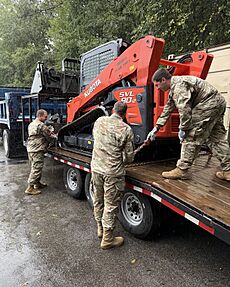
On September 28, 2024, The Salvation Army began deploying emergency disaster services teams in many areas affected by Helene. The Omaha Public Power District sent Mutual Aid crews to West Virginia to help restore power restoration after Helene, their third in a disaster in 2024. California sent 151 search and rescue members to affected areas.
See also
 In Spanish: Huracán Helene (2024) para niños
- Hurricane Michael
- Weather of 2024
- Tropical cyclones in 2024
- Timeline of the 2024 Atlantic hurricane season
- List of Category 4 Atlantic hurricanes
- List of Florida hurricanes (2000–present)


