Hot Springs Village, Arkansas facts for kids
Quick facts for kids
Hot Springs Village, Arkansas
|
|
|---|---|
| Village of Hot Springs | |

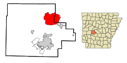
Location in Garland County and Arkansas
|
|
| Country | |
| State | |
| Counties | Garland, Saline |
| Founded | June 1, 1970 |
| Founded by | John Cooper, Sr. |
| Named for | Hot Springs |
| Government | |
| • Type | POA |
| Area | |
| • Total | 60.56 sq mi (156.84 km2) |
| • Land | 57.64 sq mi (149.28 km2) |
| • Water | 2.92 sq mi (7.56 km2) |
| Elevation | 646 ft (197 m) |
| Population
(2020)
|
|
| • Total | 15,861 |
| • Density | 275.19/sq mi (106.25/km2) |
| Time zone | UTC-6 (Central (CST)) |
| • Summer (DST) | UTC-5 (CDT) |
| ZIP codes |
71909, 71910
|
| Area code(s) | 501 |
| FIPS code | 05-33482 |
| GNIS feature ID | 2402601 |
Hot Springs Village is a census-designated place (CDP) in Garland and Saline counties in the U.S. state of Arkansas. As it is situated in two counties, it is also part of two metropolitan statistical areas. The portion in Garland County is within the Hot Springs Metropolitan Statistical Area, while the portion extending into Saline County is part of the Little Rock–North Little Rock–Conway Metropolitan Statistical Area. The population was 15,861 at the 2020 census. It is the largest gated community in the United States.
Geography
According to the United States Census Bureau, the CDP has a total area of 55.7 square miles (144 km2), of which 53.5 square miles (139 km2) is land and 2.2 square miles (5.7 km2) (3.92%) is water.
Climate
Hot Springs Village ("HSV") has four distinct seasons. Winter freezes usually begin in mid November and may occur into April. Temperatures over 100 degrees may start as early as June and may occur into September. Typically, the area will see several days of snow during the winter and minimum temperatures of 15 degrees or higher. Rainfall is usually plentiful in spring and sparse in summer.
A low-end EF2 tornado struck the town on March 14, 2024. Many homes and trees were damaged.
Demographics
| Historical population | |||
|---|---|---|---|
| Census | Pop. | %± | |
| 1980 | 2,083 | — | |
| 1990 | 6,361 | 205.4% | |
| 2000 | 8,397 | 32.0% | |
| 2010 | 12,807 | 52.5% | |
| 2020 | 15,861 | 23.8% | |
| U.S. Decennial Census | |||
2020
| Race | Number | Percentage |
|---|---|---|
| White (non-Hispanic) | 14,482 | 91.31% |
| Black or African American (non-Hispanic) | 233 | 1.47% |
| Native American | 52 | 0.33% |
| Asian | 83 | 0.52% |
| Pacific Islander | 10 | 0.06% |
| Other/Mixed | 575 | 3.63% |
| Hispanic or Latino | 426 | 2.69% |
As of the 2020 United States census, there were 15,861 people, 7,279 households, and 5,045 families residing in the CDP.
2010
As of the census of 2010, the CDP's racial demographics were 97.9% white (96.0 non-Hispanic, 1.1% White Hispanic), 1.3% Black or African-American, 0.8% American Indian and Alaska Native, 0.4% Asian, 0.0% Native Hawaiian and Other Pacific Islander, and 0.5 belonging to other races. 1.5 of the CDP's residents were Hispanic of any race.
2000
As of the census of 2000, there were 8,397 people, 4,295 households, and 3,221 families residing in the CDP. The population density was 221.4 inhabitants per square mile (85.5/km2). There were 5,121 housing units at an average density of 135.0 per square mile (52.1/km2). The racial makeup of the CDP was 97.98% White, 0.94% Black or African American, 0.14% Native American, 0.19% Asian, 0.20% from other races, and 0.55% from two or more races. 1.01% of the population were Hispanic or Latino of any race.
There were 4,295 households, out of which 6.8% had children under the age of 18 living with them, 71.5% were married couples living together, 2.8% had a female householder with no husband present, and 25.0% were non-families. 23.1% of all households were made up of individuals, and 18.4% had someone living alone who was 65 years of age or older. The average household size was 1.94 and the average family size was 2.22. In the CDP, the population was spread out, with 6.6% under the age of 18, 1.7% from 18 to 24, 8.0% from 25 to 44, 27.2% from 45 to 64, and 56.6% who were 65 years of age or older. The median age was 67 years. For every 100 females, there were 88.5 males. For every 100 females age 18 and over, there were 87.6 males.
The median income for a household in the CDP was $41,875, and the median income for a family was $48,958. Males had a median income of $35,236 versus $20,313 for females. The per capita income for the CDP was $24,492. About 1.6% of families and 2.5% of the population were below the poverty line, including 5.6% of those under age 18 and 1.9% of those age 65 or over.
Education
Hot Springs Village is located in Fountain Lake and Jessieville school districts. Fountain Lake School District operates Fountain Lake High School.
Culture and society
The private-membership Diamante Country Club has a golf course and clubhouse. Country club members bought the club from the previous owners, ClubCorp and Cooper Communities Inc., early in 2018. A weekly local newspaper, the Hot Springs Village Voice, is delivered every Tuesday.
See also
 In Spanish: Hot Springs Village (Arkansas) para niños


