Garland County, Arkansas facts for kids
Quick facts for kids
Garland County
|
||
|---|---|---|

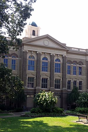
Garland County Courthouse
|
||
|
||

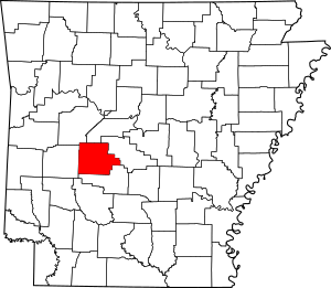
Location within the U.S. state of Arkansas
|
||
 Arkansas's location within the U.S. |
||
| Country | ||
| State | ||
| Founded | April 5, 1873 | |
| Named for | Augustus Hill Garland | |
| Seat | Hot Springs | |
| Largest city | Hot Springs | |
| Area | ||
| • Total | 735 sq mi (1,900 km2) | |
| • Land | 678 sq mi (1,760 km2) | |
| • Water | 57 sq mi (150 km2) 7.7%% | |
| Population
(2020)
|
||
| • Total | 100,180 | |
| • Density | 136.30/sq mi (52.63/km2) | |
| Time zone | UTC−6 (Central) | |
| • Summer (DST) | UTC−5 (CDT) | |
| Congressional district | 4th | |
Garland County is a county located in the U.S. state of Arkansas. As of the 2020 census, the population was 100,180. The county seat is Hot Springs.
Garland County comprises the Hot Springs, Arkansas Metropolitan Statistical Area. The county includes Hot Springs National Park, the only national park in the state of Arkansas as well as the first property to be protected under federal legislation. A law was passed in 1832 supported by President Andrew Jackson to preserve this area, even before Arkansas was admitted as a state.
Contents
History
This area was occupied by the historic Natchitoches people, who frequented the hot springs for their healing powers. Their ancestors among regional indigenous peoples had been coming to this area for thousands of years before their time.
After acquiring the Louisiana Territory in 1803, which had been controlled by French and Spanish officials, President Thomas Jefferson requested William Dunbar, a planter and amateur scientist of Natchez, Mississippi, to explore this area. Dunbar led small group of a dozen soldiers and friend George Hunter, a chemist, to the Ouachita Mountains to report on the Indian tribes, minerals, and springs. They reached Hot Springs in December 1804, where they found a basic cabin used by visitors to the springs.
The first European-American settler was Jean Pierre Emanuel Prudhomme, a descendant of French colonists. An owner of a plantation at Red River, Prudhomme was suffering from illness and sought relief from the springs. In 1807 he built the first permanent European house by the springs, living here for two years. Isaac Cates and John Percival, two trappers from Alabama, joined him. Percival foresaw a great potential for the area and built log cabins in order to rent to visitors to the springs.
In 1828, Ludovicus Belding came with wife and children to visit the hot springs. After a few months they built a small hotel for the visitors of the springs.
In 1832 President Andrew Jackson signed legislation to protect the hot springs area for recreational use by American citizens as Hot Springs Reservation, the first time such action was taken. This was four years before Arkansas became a state, on June 15, 1836. A dispute among original settlers and their descendants over control of the property was settled by the US Supreme Court in 1877 in favor of the federal government. Hot Springs National Park was established in 1921 and is managed by the National Park Service.
Garland County is Arkansas' 68th county, formed during the Reconstruction era on April 5, 1873, from portions of Hot Spring, Montgomery, and Saline counties. It was named for Augustus H. Garland, eleventh governor of Arkansas. It is the only county in the United States with this name.
Geography
According to the U.S. Census Bureau, the county has a total area of 735 square miles (1,900 km2), of which 678 square miles (1,760 km2) is land and 57 square miles (150 km2) (7.7%) is water.
Transit
- Hot Springs Intracity Transit
Major highways
Adjacent counties
- Perry County (north)
- Saline County (east)
- Hot Spring County (south)
- Montgomery County (west)
- Yell County (northwest)
National protected areas
- Hot Springs National Park
- Ouachita National Forest (part)
Demographics
| Historical population | |||
|---|---|---|---|
| Census | Pop. | %± | |
| 1880 | 9,023 | — | |
| 1890 | 15,328 | 69.9% | |
| 1900 | 18,773 | 22.5% | |
| 1910 | 27,271 | 45.3% | |
| 1920 | 25,785 | −5.4% | |
| 1930 | 36,031 | 39.7% | |
| 1940 | 41,664 | 15.6% | |
| 1950 | 47,102 | 13.1% | |
| 1960 | 46,697 | −0.9% | |
| 1970 | 54,131 | 15.9% | |
| 1980 | 70,531 | 30.3% | |
| 1990 | 73,397 | 4.1% | |
| 2000 | 88,068 | 20.0% | |
| 2010 | 96,024 | 9.0% | |
| 2020 | 100,180 | 4.3% | |
| 2023 (est.) | 99,784 | 3.9% | |
| U.S. Decennial Census 1790–1960 1900–1990 1990–2000 2010 |
|||
2020 census
| Race | Number | Percentage |
|---|---|---|
| White (non-Hispanic) | 77,239 | 77.1% |
| Black or African American (non-Hispanic) | 8,034 | 8.02% |
| Native American | 623 | 0.62% |
| Asian | 960 | 0.96% |
| Pacific Islander | 71 | 0.07% |
| Other/Mixed | 6,206 | 6.19% |
| Hispanic or Latino | 7,047 | 7.03% |
As of the 2020 United States census, there were 100,180 people, 41,743 households, and 26,006 families residing in the county.
Communities
Cities
- Hot Springs (county seat)
- Mountain Pine
Towns
Census-designated places
Unincorporated communities
Townships
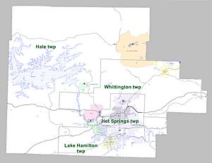
Townships in Arkansas are the divisions of a county. Each township includes unincorporated areas; some may have incorporated cities or towns within part of their boundaries. Arkansas townships have limited purposes in modern times. However, the United States Census does list Arkansas population based on townships (sometimes referred to as "county subdivisions" or "minor civil divisions"). Townships are also of value for historical purposes in terms of genealogical research. Each town or city is within one or more townships in an Arkansas county based on census maps and publications. The townships of Garland County are listed below; listed in parentheses are the cities, towns, and/or census-designated places that are fully or partially inside the township.
| Township | FIPS code | ANSI code (GNIS ID) |
Population center(s) |
Pop. (2010) |
Pop. density (/mi2) |
Pop. density (/km2) |
Total area (mi2) |
Total area (km2) |
Land area (mi2) |
Land area (km2) |
Water area (mi2) |
Water area (km2) |
Geographic coordinates |
|---|---|---|---|---|---|---|---|---|---|---|---|---|---|
| Hale | 05-91581 | 00066591 | Mountain Pine, most of CDP Hot Springs Village, small part of CDP Rockwell | 16,142 | 41.99 | 16.21 | 428.979 | 1,111 | 384.389 | 995.6 | 44.590 | 115.5 | 34°38′02″N 93°11′55″W / 34.633909°N 93.198598°W |
| Hot Springs | 05-91773 | 00066592 | most of Hot Springs | 41,479 | 801.70 | 309.54 | 54.073 | 140.0 | 51.739 | 134.0 | 2.334 | 6.045 | 34°29′40″N 93°02′52″W / 34.494338°N 93.047883°W |
| Lake Hamilton | 05-92100 | 00066594 | CDP Lake Hamilton, most of CDP Rockwell | 20,534 | 260.45 | 100.56 | 86.717 | 224.6 | 78.839 | 204.2 | 7.878 | 20.40 | 34°25′52″N 93°05′11″W / 34.431040°N 93.086323°W |
| Whittington | 05-94047 | 00066602 | Fountain Lake, Lonsdale, CDP Piney, part of CDP Hot Springs Village, small part of Hot Springs | 17,599 | 108.09 | 41.73 | 164.852 | 427.0 | 162.814 | 421.7 | 2.038 | 5.278 | 34°34′08″N 92°59′59″W / 34.568990°N 92.999676°W |
| Source:
Source: |
|||||||||||||
See also
 In Spanish: Condado de Garland para niños


