Henderson County, Tennessee facts for kids
Quick facts for kids
Henderson County
|
||
|---|---|---|

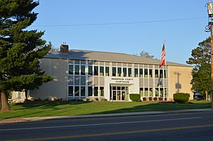
Henderson County Courthouse in Lexington
|
||
|
||

Location within the U.S. state of Tennessee
|
||
 Tennessee's location within the U.S. |
||
| Country | ||
| State | ||
| Founded | 1821 | |
| Named for | James Henderson | |
| Seat | Lexington | |
| Largest city | Lexington | |
| Area | ||
| • Total | 526 sq mi (1,360 km2) | |
| • Land | 520 sq mi (1,300 km2) | |
| • Water | 5.8 sq mi (15 km2) 1.1%% | |
| Population
(2020)
|
||
| • Total | 27,842 |
|
| • Density | 53/sq mi (20/km2) | |
| Time zone | UTC−6 (Central) | |
| • Summer (DST) | UTC−5 (CDT) | |
| Congressional district | 8th | |
Henderson County is a county located in the U.S. state of Tennessee. As of the 2020 census, the population was 27,842. Its county seat is Lexington. The county was founded in 1821 and named for James Henderson, a soldier in the War of 1812.
Contents
History
Henderson County was established in 1821; it was named for Lt. Colonel James Henderson, Jr. (1775-1814), of the Tennessee State Militia, who was killed in late December 1814 below New Orleans during a clash with the British Army. Henderson is said to have served in earlier conflicts such as the Creek Indian war, which took place during the same overall time period as the War of 1812.
After the Battle of New Orleans, Major General William Carroll's Tennessee brigade, which was the largest single force under General Andrew Jackson's command in Louisiana, established their outgoing camp upriver from New Orleans and named it Camp Henderson.
General Carroll's first term as Governor of Tennessee began the same year that Henderson County was established. Perhaps it was he who proposed naming the new county after his fallen officer James Henderson.
The county seat, Lexington, was laid out in 1822. Like many Tennessee counties, Henderson was divided during the Civil War. Confederate sentiment was strongest in the western half of the county (where most of the county's plantations were located), while Union support was strongest in the hilly eastern half.
Geography
According to the U.S. Census Bureau, the county has a total area of 526 square miles (1,360 km2), of which 520 square miles (1,300 km2) is land and 5.8 square miles (15 km2) (1.1%) is water.
The county straddles the Tennessee Valley Divide, with waters east of the divide flowing into the Tennessee River, and waters west of the divide flowing into the Mississippi River. Primary streams include the Beech River and the Forked Deer River.
Adjacent counties
- Carroll County (north)
- Decatur County (east)
- Hardin County (southeast)
- Chester County (southwest)
- Madison County (west)
State protected areas
- Natchez Trace State Forest (part)
- Natchez Trace State Park (part)
Major Highways
 I-40
I-40 US 70
US 70 US 412
 SR 22
SR 22 SR 22A
 SR 104
Demographics
| Historical population | |||
|---|---|---|---|
| Census | Pop. | %± | |
| 1830 | 8,748 | — | |
| 1840 | 11,875 | 35.7% | |
| 1850 | 13,164 | 10.9% | |
| 1860 | 14,491 | 10.1% | |
| 1870 | 14,217 | −1.9% | |
| 1880 | 17,430 | 22.6% | |
| 1890 | 16,336 | −6.3% | |
| 1900 | 18,117 | 10.9% | |
| 1910 | 17,030 | −6.0% | |
| 1920 | 18,436 | 8.3% | |
| 1930 | 17,655 | −4.2% | |
| 1940 | 19,220 | 8.9% | |
| 1950 | 17,173 | −10.7% | |
| 1960 | 16,115 | −6.2% | |
| 1970 | 17,291 | 7.3% | |
| 1980 | 21,390 | 23.7% | |
| 1990 | 21,844 | 2.1% | |
| 2000 | 25,522 | 16.8% | |
| 2010 | 27,769 | 8.8% | |
| 2020 | 27,842 | 0.3% | |
| U.S. Decennial Census 1790-1960 1900-1990 1990-2000 2010-2014 |
|||
2020 census
| Race | Num. | Perc. |
|---|---|---|
| White (non-Hispanic) | 23,890 | 85.81% |
| Black or African American (non-Hispanic) | 1,931 | 6.94% |
| Native American | 53 | 0.19% |
| Asian | 90 | 0.32% |
| Pacific Islander | 2 | 0.01% |
| Other/Mixed | 1,157 | 4.16% |
| Hispanic or Latino | 719 | 2.58% |
As of the 2020 United States census, there were 27,842 people, 10,711 households, and 7,113 families residing in the county.
Transportation
The Beech River Regional Airport is a public-use airport located five nautical miles (5.8 mi; 9.3 km) northwest of the central business district of Parsons, a city in Decatur County. The airport is located in Darden, Tennessee.
Communities
City
- Lexington (county seat)
- Parkers Crossroads
Town
- Sardis
- Scotts Hill (partial)
Census-designated places
Unincorporated communities
See also
 In Spanish: Condado de Henderson (Tennessee) para niños


