Giessenlanden facts for kids
Quick facts for kids
Giessenlanden
|
|||
|---|---|---|---|

Castle in Schelluinen
|
|||
|
|||

Location in South Holland
|
|||
| Country | Netherlands | ||
| Province | South Holland | ||
| Municipality | Molenlanden | ||
| Established | 1 January 1986 | ||
| Merged | 2019 | ||
| Area | |||
| • Total | 65.11 km2 (25.14 sq mi) | ||
| • Land | 63.57 km2 (24.54 sq mi) | ||
| • Water | 1.54 km2 (0.59 sq mi) | ||
| Elevation | −1 m (−3.3 ft) | ||
| Population
(May 2014)
|
|||
| • Total | 14,476 | ||
| • Density | 228/km2 (590/sq mi) | ||
| Time zone | UTC+1 (CET) | ||
| • Summer (DST) | UTC+2 (CEST) | ||
| Postcode |
3380–3381, 4209, 4220–4225, 4240–4241
|
||
| Area code | 0183, 0184 | ||
Giessenlanden (Dutch: [ˈɣisə(n)ˌlɑndə(n)]) is a former municipality in the western Netherlands, in the province of South Holland. The municipality covered an area of 65.11 km2 (25.14 sq mi) of which 1.54 km2 (0.59 sq mi) is water, and had a population of 14,476 as of 2014. The municipality included communities of Arkel, Giessen-Oudekerk, Giessenburg, Hoogblokland, Hoornaar, Noordeloos and Schelluinen.
On 1 January 2019, it merged with Molenwaard to form the new municipality of Molenlanden.
Topography
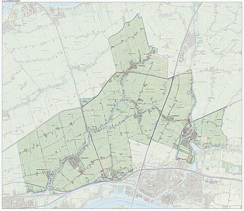
Dutch topographic map of the municipality of Giessenlanden, June 2015
Public transportation
The Arkel railway station, on the Elst–Dordrecht railway, is situated in the municipality Giessenlanden.
See also
 In Spanish: Giessenlanden para niños

All content from Kiddle encyclopedia articles (including the article images and facts) can be freely used under Attribution-ShareAlike license, unless stated otherwise. Cite this article:
Giessenlanden Facts for Kids. Kiddle Encyclopedia.


