Geography of the United States facts for kids

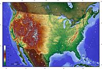
The United States is the third or fourth biggest country in the world. Only Russia and Canada are bigger. If you do not count the area of the Great Lakes, China is also bigger. Its geography varies a lot. The area is about 3,717,000 square miles, or about 9,629,000 square kilometers. The highest point is Mount McKinley, Alaska and the lowest point is Death Valley, California.
- There are meadows and forests on the East Coast,
- The Appalachian Mountains in the east
- The Great Plains in the middle of the country,
- The Mississippi-Missouri river,in the middle
- The Rocky Mountains west of the plains
- Deserts and coastal areas west of the Rocky Mountains
- Forests in the Pacific Northwest
- Arctic regions of Alaska
- Volcanic islands in Hawaii
- Long coastline, many beaches
The geographic center is in Butte County, South Dakota. The geographic center of the 48 states is in Smith County, Kansas.
Contents
Climate
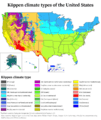
The climate varies along with the geography, from tropical (hot and wet in summer, warm and dry in winter) in Florida and Hawaii to tundra (cold all year) in Alaska. Large parts of the country have warm summers and cold winters. Most of the northern U.S. gets snow in winter. Some parts of the western United States, like parts of California, have a Mediterranean climate. The southeastern United States can get hurricanes. Parts of the southern United States are subtropical (hot in summer and cool in winter). Tornadoes happen a lot in the Midwest.
The highest recorded temperature is 134 degrees Fahrenheit (57 degrees Celsius) and the lowest recorded temperature is -80 degrees Fahrenheit (-62 degrees Celsius).
Gallery
-
The Grand Canyon
-
the Everglades and Florida Keys
-
the Shenandoah Valley in Virginia
-
A satellite composite image of the contiguous United States. Deciduous vegetation and grasslands prevail in the east, transitioning to prairies, boreal forests, and the Rockies in the west, and deserts in the southwest. In the northeast, the coasts of the Great Lakes and Atlantic seaboard host much of the country's population.
-
A physiographical map of the contiguous 48 states of the U.S. The map indicates the age of the exposed surface as well as the type of terrain.
-
Much of the central United States is covered by relatively flat, arable land. This aerial photo was taken over northern Ohio.
-
A powerful tornado near Dimmitt, Texas on June 2, 1995.
-
Total devastation in Gulfport, Mississippi caused by storm surge from Hurricane Katrina in 2005.
Images for kids
-
Political map of the United States showing the 50 states, the District of Columbia and the 5 major U.S. territories.
-
A satellite composite image of the state of Hawaii. Volcanoes prevail on the Big Island. The islands have rugged coastlines, sandy beaches and a tropical environment, although temperatures and humidity tend to be less extreme because of near-constant trade winds from the east.
-
Köppen climate types of the US (including the 5 inhabited U.S. territories)
-
Pago Pago Harbor in American Samoa has the highest annual rainfall of any harbor in the world.
See also
 In Spanish: Geografía de Estados Unidos para niños


