Gap, Hautes-Alpes facts for kids
Quick facts for kids
Gap
|
||
|---|---|---|
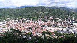
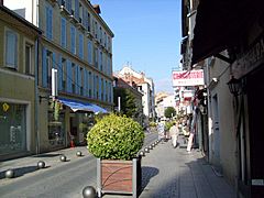
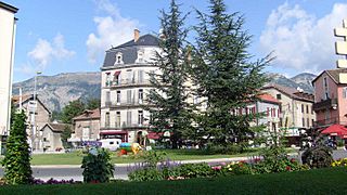
View of Gap.
|
||
|
||
| Country | France | |
| Region | Provence-Alpes-Côte d'Azur | |
| Department | Hautes-Alpes | |
| Arrondissement | Gap | |
| Canton | Chief town of 4 cantons | |
| Intercommunality | CA Gap-Tallard-Durance | |
| Area
1
|
110.43 km2 (42.64 sq mi) | |
| Population
(2014)
|
40,225 | |
| • Density | 364.258/km2 (943.42/sq mi) | |
| Time zone | UTC+01:00 (CET) | |
| • Summer (DST) | UTC+02:00 (CEST) | |
| INSEE/Postal code |
05061 /05000
|
|
| Elevation | 625–2,360 m (2,051–7,743 ft) (avg. 1,493 m or 4,898 ft) |
|
| Website | www.ville-gap.fr | |
| 1 French Land Register data, which excludes lakes, ponds, glaciers > 1 km2 (0.386 sq mi or 247 acres) and river estuaries. | ||
Gap is a commune in the Hautes-Alpes department in the Provence-Alpes-Côte d'Azur region in southeastern France. It is the préfecture (capital), and main city, of the department.
Gap is the highest prefecture (departmental capital) of France; the city is in a valley whose bottom is at an altitude of about 735 m (2,411 ft) above sea level.
Contents
Geography
Gap is in the south central part of the Hautes-Alpes department. The Luye, a tributary of the Durance river, flows through the city.
It has an area of 110.4 km2 (42.6 sq mi). Its average altitude is 1,493 m (4,898 ft); at the city hall, the altitude is 767 m (2,516 ft).
The distances from Gap to other cities are:
- Paris, the national capital - 674 km (419 mi);
- Marseille, the regional capital - 180 km (110 mi);
- Strasbourg - 676 km (420 mi);
- Reims - 698 km (434 mi);
- Bordeaux - 775 km (482 mi);
- Toulouse - 538 km (334 mi);
- Montpellier - 299 km (186 mi);
- Lyon - 204 km (127 mi);
- Nice - 288 km (179 mi).
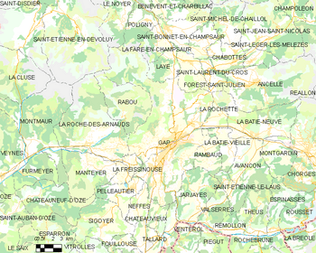 |
The commune of Gap is surrounded by 17 communes: Laye, Saint-Laurent-du-Cros, Forest-Saint-Julien, La Rochette, Rambaud, Jarjayes, Neffes, Châteauvieux, Lettret, Pelleautier, La Roche-des-Arnauds, La Freissinouse, La Fare-en-Champsaur, Poligny, Le Noyer, Le Dévoluy, Rabou
 |
La Fare-en-Champsaur, Poligny, Le Noyer, Le Dévoluy, Rabou | Laye, Saint-Laurent-du-Cros | Forest-Saint-Julien, La Rochette |  |
| La Roche-des-Arnauds La Freissinouse |
Rambaud | |||
| Pelleautier | Neffes, Châteauvieux, Lettret | Jarjayes |
Climate
The climate of Gap, in the Köppen climate classification, is Cfb - Oceanic climate with template summers.
Population
The inhabitants of Gap are known, in French, as Gapençais (women: Gapençaises).
With a population of 40,225, Gap has a population density of 364 inhabitants/km2.
Evolution of the population in Gap
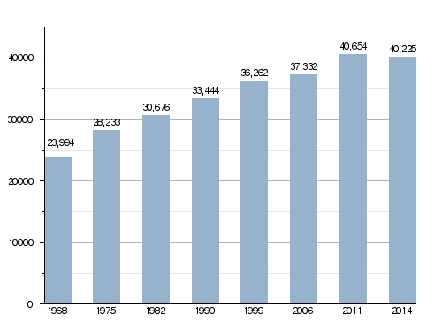
Gap forms with La Rochette the urban area of Gap with a population of 40,700 inhabitants (2014) and an area of 120.8 km2 (46.6 sq mi). This urban area is the centre of the metropolitan area of Gap, formed by 39 communes, with a population of 62,567 inhabitants (2014) and an area of 756.6 km2 (292.1 sq mi).
Administration
Gap is the prefecture of the Hautes-Alpes department, the capital of the arrondissement of Gap and the administrative centre (French: chef-lieu) of four cantons:
- Gap-1 formed by a part of Gap, with 9,895 inhabitants (2014).
- Gap-2 formed by a part of Gap, with 10,743 inhabitants (2014).
- Gap-3 formed by a part of Gap, with 10,346 inhabitants (2014).
- Gap-4 formed by a part of Gap, with 9,241 inhabitants (2014).
It is part of the intercommunality Gap-Tallard-Durance (French: Communauté d'agglomération Gap-Tallard-Durance).
Twin towns
Gap is twinned with:
 Pinerolo, Italy, since 1966;
 Traunstein, Germany, since 1976.
Gallery
Related pages
Images for kids
-
Bilingual signage in Alpine Provençal and in French at Gap
See also
 In Spanish: Gap (Altos Alpes) para niños


