Laye facts for kids
Quick facts for kids
Laye
|
||
|---|---|---|

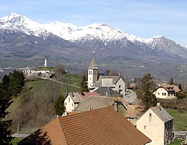
The church and the surrounding buildings in Laye
|
||
|
||
| Country | France | |
| Region | Provence-Alpes-Côte d'Azur | |
| Department | Hautes-Alpes | |
| Arrondissement | Gap | |
| Canton | Saint-Bonnet-en-Champsaur | |
| Intercommunality | Champsaur | |
| Area
1
|
10.55 km2 (4.07 sq mi) | |
| Time zone | UTC+01:00 (CET) | |
| • Summer (DST) | UTC+02:00 (CEST) | |
| INSEE/Postal code |
05072 /05500
|
|
| Elevation | 976–2,158 m (3,202–7,080 ft) (avg. 1,200 m or 3,900 ft) |
|
| 1 French Land Register data, which excludes lakes, ponds, glaciers > 1 km2 (0.386 sq mi or 247 acres) and river estuaries. | ||
Laye is a commune in the Hautes-Alpes department.
Population
| Historical population | ||
|---|---|---|
| Year | Pop. | ±% |
| 1962 | 125 | — |
| 1968 | 155 | +24.0% |
| 1975 | 137 | −11.6% |
| 1982 | 163 | +19.0% |
| 1990 | 192 | +17.8% |
| 1999 | 212 | +10.4% |
| 2008 | 231 | +9.0% |
Transport
Road
The D14, D88, D217A, and N85 roads pass through the commune.

All content from Kiddle encyclopedia articles (including the article images and facts) can be freely used under Attribution-ShareAlike license, unless stated otherwise. Cite this article:
Laye Facts for Kids. Kiddle Encyclopedia.


