GSSP facts for kids

A GSSP, more fully a Global Boundary Stratotype Section and Point, is an internationally agreed point which defines the start of a stage on the geologic time scale.
The work is done by the International Commission on Stratigraphy, a part of the International Union of Geological Sciences. As of 2012, 64 of the 101 stages that need a GSSP have been decided.
Rules for GSSP
A geologic section has to follow the rules to be adapted as a GSSP by the ICS. The list below are the rules:
- A GSSP has to decide the lower boundary (start of a geological period) of a geologic stage.
- The lower boundary (start of a geological period) has to be decided using a primary (main) marker (usually first appearance datum of a fossil specie).
- There should also be secondary markers (other fossils, chemical, geomagnetic reversal).
- The horizon in which the marker appears should have minerals that can be radiometrically dated.
- The marker has to have regional and global correlation in outcrops of the same age
- The marker should be independent of facies.
- The outcrop has to have an acceptable thickness
- Sedimentation has to be constant without any changes in facies
- The outcrop should not be affected by tectonic and sedimentary movements, and metamorphism
- The outcrop has to be accessible to research and free to access.
- This includes that the outcrop has to be located where it can be visited quickly (International airport and good roads), has to be kept in good condition (Ideally a national reserve), in accessible terrain, extensive enough to allow repeated sampling and open to researchers of all nationalities.
List
This list shows some of the GSSPs.
| Period | Epoch | Age (mya) | Status | GSSP location | Defining markers | Geographic Coordinates | References |
|---|---|---|---|---|---|---|---|
| Phanerozoic | |||||||
| Cainozoic | |||||||
| Quaternary | |||||||
| Holocene | 0.117 | NGRIP2 ice core, |
|
75°06′00″N 42°19′12″W / 75.1000°N 42.3200°W | |||
| Pleistocene | 2.588 | Monte San Nicola Section, |
|
37°08′49″N 14°12′13″E / 37.1469°N 14.2035°E | |||
| Neogene | |||||||
| Pliocene | 5.333 | Heraclea Minoa section |
|
37°23′30″N 13°16′50″E / 37.3917°N 13.2806°E | |||
| Miocene | 23.03 | Lemme-Carrosio Section,
Carrosio, Italy |
|
44°39′32″N 8°50′11″E / 44.6589°N 8.8364°E | |||
| Palaeogene | |||||||
| Oligocene | 33.9 | Massignano Section, |
|
43°31′58″N 13°36′04″E / 43.5328°N 13.6011°E | |||
| Eocene | 56 | Dababiya section, |
|
25°30′00″N 32°31′52″E / 25.5000°N 32.5311°E | |||
| Palaeocene | 66 | El Kef Section,
El Kef, Tunisia |
|
36°09′13″N 8°38′55″E / 36.1537°N 8.6486°E | |||
| Mesozoic | |||||||
| Cretaceous | |||||||
| Upper Cretaceous | 100.5 | Mont Risoux, |
|
44°23′33″N 5°30′43″E / 44.3925°N 5.5119°E | |||
| Lower Cretaceous | 145 |
Candidates:
|
|||||
| Jurassic | |||||||
| Upper Jurassic | 163.5 | Candidate sections:
|
|
||||
| Middle Jurassic | 174.1 | Fuentelsaz, Spain |
|
41°10′15″N 1°50′00″W / 41.1708°N 1.8333°W | |||
| Lower Jurassic | 201.3 | Kuhjoch section, Karwendel mountains, Northern Calcareous Alps, Austria |
|
47°29′02″N 11°31′50″E / 47.4839°N 11.5306°E | |||
| Triassic | |||||||
| Upper Triassic | 235 | Prati di Stuores, Dolomites, Italy | 46°31′37″N 11°55′49″E / 46.5269°N 11.9303°E | ||||
| Middle Triassic | 247.2 | Candidate sections: |
|
45°04′27″N 28°48′08″E / 45.0742°N 28.8022°E | |||
| Lower Triassic | 252.2 | Meishan, Zhejiang, China |
|
31°04′47″N 119°42′21″E / 31.0798°N 119.7058°E | |||
| Palaeozoic | |||||||
| Permian | 298.9 | Aidaralash, Ural Mountains, Kazakhstan |
|
50°14′45″N 57°53′29″E / 50.2458°N 57.8914°E | |||
| Carboniferous | |||||||
| Pennsylvanian | 323.2 | Arrow Canyon, Nevada, USA |
|
36°44′00″N 114°46′40″W / 36.7333°N 114.7778°W | |||
| Mississippian | 358.9 | La Serre, Montagne Noire, France |
|
43°33′20″N 3°21′26″E / 43.5555°N 3.3573°E | |||
| Devonian | 419.2 | Klonk, Prague, Czech Republic |
|
49°51′18″N 13°47′31″E / 49.8550°N 13.7920°E | |||
| Silurian | 443.4 | Dob's Linn, Moffat, U.K. |
|
55°26′24″N 3°16′12″W / 55.4400°N 3.2700°W | |||
| Ordovician | 485.4 | Greenpoint section |
|
49°40′58″N 57°57′55″W / 49.6829°N 57.9653°W | |||
| Cambrian | 541 | Fortune head section, |
|
47°04′34″N 55°49′52″W / 47.0762°N 55.8310°W | |||
| Era | Period | Precambrian | |||||
| Proterozoic | |||||||
| Neoproterozoic | |||||||
| Ediacaran | 635 | Enorama Creek section |
|
31°19′53″S 138°38′00″E / 31.3314°S 138.6334°E | |||
| Cryogenian | 850 | Defined chronometrically now. GSSP is in progress. | |||||
| Tonian | 1000 | Defined chronometrically | |||||
| Mesoproterozoic | |||||||
| Stenian | 1200 | Defined chronometrically | |||||
| Ectasian | 1400 | Defined chronometrically | |||||
| Calymmian | 1600 | Defined chronometrically | |||||
| Palaeoproterozoic | |||||||
| Statherian | 1800 | Defined chronometrically | |||||
| Orosirian | 2050 | Defined chronometrically | |||||
| Rhyacian | 2300 | Defined chronometrically | |||||
| Siderian | 2500 | Defined chronometrically | |||||
| Archaean & Hadean | |||||||
| Neoarchaean | 2800 | ||||||
| Mesoarchaean | 3200 | ||||||
| Palaeoarchaean | 3600 | ||||||
| Eoarchaean | 4000 | ||||||
| Hadean | 4567 | ||||||
Global Standard Stratigraphic Age (GSSAs)
Because defining a GSSP depends on finding well-preserved geologic sections and identifying key events, this task becomes more harder as one goes farther back in time. Before 640 million years ago, boundaries on the geologic timescale are defined simply by reference to fixed dates, known as "Global Standard Stratigraphic Ages". The oldest GSSP is the one that marks the start of the Ediacaran at 635 million years ago.
Images for kids
-
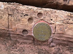
The 'golden spike' (bronze disk in the lower section of the image) or 'type section' of the Global Boundary Stratotype Section and Point (GSSP) for the base of Ediacaran period (Ediacara, South Australia)
See also
 In Spanish: Sección estratotipo y punto de límite global para niños


