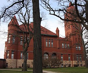
Faribault County, Minnesota facts for kids
Quick facts for kids
Faribault County
|
|
|---|---|

Faribault County Courthouse in Blue Earth
|
|

Location within the U.S. state of Minnesota
|
|
 Minnesota's location within the U.S. |
|
| Country | |
| State | |
| Founded | February 20, 1855 |
| Named for | Jean Baptiste Faribault |
| Seat | Blue Earth |
| Largest city | Blue Earth |
| Area | |
| • Total | 722 sq mi (1,870 km2) |
| • Land | 712 sq mi (1,840 km2) |
| • Water | 9.4 sq mi (24 km2) 1.3%% |
| Population
(2020)
|
|
| • Total | 13,921 |
| • Estimate
(2023)
|
13,873 |
| • Density | 19.281/sq mi (7.444/km2) |
| Time zone | UTC−6 (Central) |
| • Summer (DST) | UTC−5 (CDT) |
| Congressional district | 1st |
Faribault County (/ˈfɛərboʊ/ FAIR-boh) is a county in the U.S. state of Minnesota. As of the 2020 census, the population was 13,921. Its county seat is Blue Earth.
Contents
History
The county was founded in 1855. It was named for Jean-Baptiste Faribault, a settler and French fur trader among the Sioux Indians.
Geography
Faribault County lies on the south side of Minnesota. Its southern border abuts the north border of the state of Iowa. The Blue Earth River flows northerly through the west-central part of the county; it enters from Iowa as two branches, West Branch and Middle Branch, merging at 5 miles (8.0 km) into the county. It is joined by East Branch near the city of Blue Earth, thence flows northward into Blue Earth County. The Maple River flows west-northwestward through the upper central part of the county, entering from Freeborn County and exiting to Blue Earth County. The Cobb River also flows through the NE part of the county, from Freeborn to Blue Earth county.
The county terrain consists of semi-arid rolling hills, devoted to agriculture. The SE portion is a glacial moraine near Kiester, and is known as the Kiester Moraine. The county has an area of 722 square miles (1,870 km2), of which 712 square miles (1,840 km2) is land and 9.4 square miles (24 km2) (1.3%) is water.
Lakes
Source:
- Bass Lake (Delavan Twp)
- Hart Lake
- Minnesota Lake
- Rice Lake (Delavan Twp)
- Rice Lake (Foster Twp)
- South Walnut Lake
- Walnut Lake
Airports
Source:
- Blue Earth Municipal Airport
- Wells Municipal Airport
Major highways
 Interstate 90
 U.S. Highway 169
 Minnesota State Highway 22
 Minnesota State Highway 109
Adjacent counties
- Blue Earth County - north
- Waseca County - northeast
- Freeborn County - east
- Winnebago County, Iowa - southeast
- Kossuth County, Iowa - southwest
- Martin County - west
Protected areas
Source:
- Walnut Lake State Wildlife Management Area
Demographics
| Historical population | |||
|---|---|---|---|
| Census | Pop. | %± | |
| 1860 | 1,335 | — | |
| 1870 | 9,940 | 644.6% | |
| 1880 | 13,016 | 30.9% | |
| 1890 | 16,708 | 28.4% | |
| 1900 | 22,055 | 32.0% | |
| 1910 | 19,949 | −9.5% | |
| 1920 | 20,998 | 5.3% | |
| 1930 | 21,642 | 3.1% | |
| 1940 | 23,941 | 10.6% | |
| 1950 | 23,879 | −0.3% | |
| 1960 | 23,685 | −0.8% | |
| 1970 | 20,896 | −11.8% | |
| 1980 | 19,714 | −5.7% | |
| 1990 | 16,937 | −14.1% | |
| 2000 | 16,181 | −4.5% | |
| 2010 | 14,553 | −10.1% | |
| 2020 | 13,921 | −4.3% | |
| 2023 (est.) | 13,873 | −4.7% | |
| U.S. Decennial Census 1790-1960 1900-1990 1990-2000 2010-2020 |
|||
2020 Census
| Race | Num. | Perc. |
|---|---|---|
| White (NH) | 12,402 | 89.1% |
| Black or African American (NH) | 55 | 0.4% |
| Native American (NH) | 58 | 0.4% |
| Asian (NH) | 45 | 0.3% |
| Pacific Islander (NH) | 0 | 0% |
| Other/Mixed (NH) | 348 | 2.5% |
| Hispanic or Latino | 1,013 | 7.3% |
Communities
Cities
Unincorporated communities
Townships
- Barber Township
- Blue Earth City Township
- Brush Creek Township
- Clark Township
- Delavan Township
- Dunbar Township
- Elmore Township
- Emerald Township
- Foster Township
- Jo Daviess Township
- Kiester Township
- Lura Township
- Minnesota Lake Township
- Pilot Grove Township
- Prescott Township
- Rome Township
- Seely Township
- Verona Township
- Walnut Lake Township
- Winnebago City Township
Education
School districts include:
- Alden-Conger Public School District
- Blue Earth Area Public Schools
- Granada-Huntley-East Chain School District
- Janesville-Waldorf-Pemberton School District
- Maple River School District
- United South Central School District
It also has the following state-operated schools:
- Minnesota State Academy for the Blind
- Minnesota State Academy for the Deaf
See also
 In Spanish: Condado de Faribault para niños

