False Bay facts for kids
Quick facts for kids False Bay |
|
|---|---|
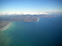
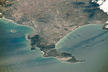
Eastern False Bay coast aerial view looking somewhat south of east: Gordon's Bay (left) to Cape Hangklip (right)
|
|
| Coordinates | 34°13′47″S 18°38′43″E / 34.22972°S 18.64528°E |
| Native name | Valsbaai |
| Ocean/sea sources | Southern Atlantic Ocean |
| Basin countries | South Africa |
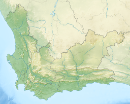
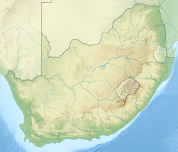
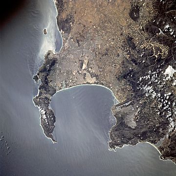
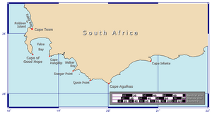
False Bay (Afrikaans Valsbaai) is a body of water in the Atlantic Ocean between the mountainous Cape Peninsula and the Hottentots Holland Mountains in the extreme south-west of South Africa. The mouth of the bay faces south and is demarcated by Cape Point to the west and Cape Hangklip to the east. The north side of the bay is the low-lying Cape Flats. Much of the bay is on the coast of the City of Cape Town, and it includes part of the Table Mountain National Park Marine Protected Area and the whole of the Helderberg Marine Protected Area.
False Bay also contains South Africa's largest naval base at Simon's Town (historically a base for the Royal Navy), and small fishing harbours at Kalk Bay and Gordon's Bay
Contents
Description and location
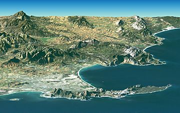
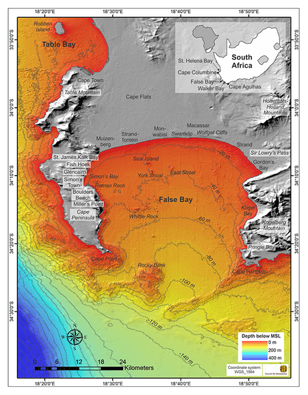
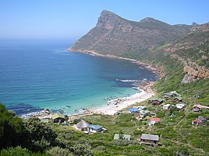
The western side is bordered by the Cape Peninsula, and this stretch of coastline includes the smaller Smitswinkel Bay, Simon's Bay and Fish Hoek Bay. At Muizenberg the coastline becomes relatively low and sandy and curves east across the southern boundary of the Cape Flats to Gordon's Bay to form the northern boundary of False Bay. From Gordon's Bay the coastline swings roughly south, and zig-zags its way along the foot of the Hottentots Holland Mountains to Cape Hangklip which is at nearly the same latitude as Cape Point. The highest peak on this side is Kogelberg at 1,269 m.
In plan the bay is approximately square with rather wobbly edges, being roughly the same extent from north to south as east to west (30 km), with the entire southern side open to the ocean. The area of False Bay has been measured at about 1,090 km2, and the volume is approximately 45 km3 (average depth about 40 m). The land perimeter has been measured at 116 km, from a 1:50,000 scale map.
The eastern and western shores of the bay are very rocky and even mountainous; in places large cliffs plunge into the water. Notable peaks associated with the bay include Koeëlberg (1,289 m (4,229 ft)), which rises from the water itself forming the highest point of the Kogelberg, as well as Somerset Sneeukop (1590m / 5217 feet) and Wemmershoek Peak (1,788 m (5,866 ft)) which are clearly visible across the bay. Some of the highest peaks visible across False Bay include Du Toits Peak near Paarl (1,995 m (6,545 ft)), Klein Winterhoek Peak near Tulbagh (1,995 m (6,545 ft)), Mostertshoek Peak at the Western extreme of the Michell's Pass (2,008 m (6,588 ft)) and Groot Winterhoek Peak North of Tulbagh (2,077 m (6,814 ft)). The northern shore, however, is defined by a very long, curving, sandy beach. This sandy, northern perimeter of the bay is the southern edge of the area known as the Cape Flats. The bay is 30 km wide at its widest point.
Suburbs of Greater Cape Town now stretch right across the Cape Flats from Simon's Town halfway down the Cape Peninsula to the north-eastern corner at Gordon's Bay. There are also two small towns of the Overberg region on the east coast of the bay, Rooi-Els and Pringle Bay.
Bottom morphology
The bottom morphology of False Bay is generally smooth and fairly shallow, sloping gently downwards from north to south, so that the depth at the centre of the mouth is about 80 m. The bottom is covered with sediment which ranges from very coarse to very fine, with most of the fine sediment and mud in the centre of the bay. The main exception is a long ridge of sedimentary rock that extends in a southward direction from off the Strand, to approximately level with the mouth of the Steenbras River. The southern tip of this ridge is known as Steenbras Deep.
There is one true island in the bay, Seal Island, a barren and stony outcrop of granite about 200 m long and with an area of about 2 ha. It is about 6km south of Strandfontein and is less than 10 m above sea level at its highest point. There are also a number of small rocky islets which extend above the high water mark, and other rocks and shoals which approach the surface. The largest of these, and the most significant navigational hazard in the bay, is Whittle Rock, a large outcrop of granite about halfway into the bay and a quarter of the way across from the Cape Peninsula, which is about a kilometre in diameter and rises to within 4 m of the surface. Most of these reefs are granite of the Peninsula pluton, but east of Seal Island they are generally sandstone, probably of the Table Mountain series, though it is possible that some may be of the underlying Tygerberg formation.
Outside the bay, but influencing the wave patterns in it, is Rocky Bank, an extensive area of sandstone reef between 20 and 30 m depth.
Bathymetry
The Bathymetry of False Bay differs in character from the west side of the Cape Peninsula. The west coast seabed tends to slope down more steeply than in False Bay, and although the close inshore waters are also shallow, the 100 m contour is mostly within about 10km of the west coast, while the entire False Bay is shallower than about 80 m. The bottom of the bay slopes down relatively gradually from the gently sloping beaches of the north shore to the mouth, and is fairly even depth from east to west except close to the shorelines, with three major features disrupting this gentle slope. These are Seal island, Whittle Rock, and the Steenbras ridge. Just outside the bay, there is a large shoal area at Rocky Bank, and a large ridge extending south-west from Cape Hangklip, which channels cold, nutrient-rich water into the west side of the bay during upwelling events.
Geology
The three main rock formations are the late-Precambrian Malmesbury group (metamorphic rock), the Peninsula granite, a huge batholith that was intruded into the Malmesbury Group about 630 million years ago, and the Table Mountain group sandstones that were deposited on the eroded surface of granite and Malmesbury series basement about 450 million years ago. The sand, silt and mud deposits were lithified by pressure and then folded during the Cape Orogeny to form the Cape Fold Belt, which extends along the western and southern coasts. The present landscape is due to prolonged erosion having carved out deep valleys, removing parts of the once continuous Table Mountain Group sandstone cover from the Cape Flats and leaving high residual mountain ridges.
At times the sea covered the Cape Flats and Noordhoek valley and the Cape Peninsula was then a group of islands. During glacial periods the sea level dropped to expose the bottom of False Bay to weathering and erosion. The last major regression leaving the entire bottom of False Bay exposed. During this period an extensive system of dunes was formed on the sandy floor of False Bay. At this time the drainage outlet lay between Rocky Bank and Hangklip Ridge.
History
In pre-colonial times False Bay was exploited by Khoisan who collected seafood from the shores and deposited the shells in middens along the coast which indicate usage over some 10 000 years. Bartolomeu Dias in 1488 first referred to the bay as "the gulf between the mountains" (Schirmer, 1980). The name "False Bay" was applied early on (at least three hundred years ago) by sailors who confused the bay with Table Bay to the north. According to Schirmer, the confusion arose because sailors returning from the east (The Dutch East Indies) initially confused Cape Point and Cape Hangklip, which are somewhat similar in form. Hangklip was known to the early Portuguese seafarers as Cabo Falso, or False Cape, and the name of the bay derived from the cape. Commercial fishing was started in the late 17th century soon after settlement by the Dutch.
In 1672 the Dutch warship Goudvinck was stationed at the Cape and was instructed to survey False Bay, but it is not known how much was done before they were recalled. Simon van der Stel, appointed commander of the station in 1679, sailed False Bay in November 1687 on the ship De Noord, and took the earliest recorded soundings, and described the islands, reefs and shoreline of the bay. By the end of the 17th century the general bathymetry was known.
Commercial fishing has been practiced in False bay since the late 1600s Over time a range of fishing methods have been prohibited in False Bay. Demersal trawling, purse seining and gillnetting were introduced in the 19th century, but have been stopped as they were depleting stocks, conflicting with other fisheries and users, and damaging the environment. Illegal gillnetting is still a problem.
Penguin eggs were collected until 1968, whaling operations took place until 1975, seals were hunted for fur until 1984, and guano was collected until 1991. All of these activities had a severely detrimental effect on the targeted populations and are now illegal. Commercial abalone diving has been severely restricted as the resource was overfished but illegal exploitation of the resource continues. Recreational abalone extraction has been discontinued.
There have been symposia, in 1968 and 1989, on the socio-ecological importance of False Bay, with reviews of the oceanography and biology of the bay and human impact on it.
Climate
The climate is Mediterranean, with warm, dry summers and cool, damp winters. In winter gales and storms from the northwest are common and can be ferocious. False Bay is exposed to southeasterly winds in summer and its waters are approximately 6 °C warmer than those of Table Bay, owing to the influence of the warm Agulhas Current.
Marine life
- Great white shark
- Cape fur seal
- Cetaceans
- Southern right whale
- Humpback whale
- Bryde's whale
- Pygmy right whale
- Heaviside's dolphin
- Dusky dolphin
- Indo-Pacific bottlenose dolphin
- Indo-Pacific humpback dolphin
- Long-beaked common dolphin
- Killer whale
Economic value
Extractive exploitation of resources
The only current commercial fisheries remaining in False Bay are linefishing for pelagic snoek and yellowtail and demersal species hottentot, kob, white stumpnose, geelbek and roman, trapping of west coast rock lobster, and beach-seine fishing (treknet). There are experimental fisheries such as for octopus, but this has been controversial due to entanglement of whales in the trap recovery lines. The demersal shark longline fishery also occasionally operates on the southeastern side of the bay.
Commercial line-fishing remains mostly hand-line fishing using baited lines.
Recreational fishing is the largest and most economically important fishery in the bay. It includes boat based angling and shore angling both from the rocky coast and from sandy beaches, and angling in estuaries, spearfishing and cast netting.
The beach-seine or treknet fishery has provided fish for over 300 years. Traditional fishing communities account for a large part of the traditional line-fish, lobster, and beach-seine fisheries, as crew or rights-holders, or by illegal fishing. Snoek and harder are an important part of the informal trade system in the traditional fishing communities, and contribute towards local food security.
The sea bamboo kelp Ecklonia maxima is harvested as whole kelp, kelp fronds, and stranded drift, for use as feed for farmed abalone and as a plant growth stimulant, in quantities considered far below the sustainable yield. No other seaweeds are harvested commercially in False Bay.
Recreational pursuits and tourism
Fishing can be good in False Bay and at times there are large schools of snoek, an oily, barracuda-like fish that is much sought after locally, and Yellowtail. Angling from the rocky shores to either side of the bay is very popular, but can be dangerous. The shape of the seabed at the mouth of the bay creates interference patterns in the swells that come in from the Southern Ocean and these patterns occasionally combine to cause "killer waves" to rise up without obvious warning and to sweep the sandstone ledges well above the high tide mark. A number of rock anglers have been swept away and drowned over the years, but this seems to have done little to dampen enthusiasm for the sport.
Sailing is also a popular recreational activity in False Bay. The sailing clubs in False Bay include False Bay Yacht Club in Simon's Town, Fish Hoek Beach Sailing Club at the main beach in Fish Hoek, Gordon's Bay Yacht Club in the Gordon's Bay Harbour, and Hottentots Holland Beach Sailing Club in Strand. The moorings at the False Bay Yacht club are well protected from south easterly waves as they are in the lee of the naval base harbour, and are in the lee of the peninsula for westerly waves, and the water is relatively deep. The marina at Harbour Island in Gordon's Bay is protected against swells from all directions, but the entrance and inshore approaches are exposed to large south-westerly seas. Gordon's Bay harbour is largely silted up by sand, and access by keeled sailing yachts is limited by draught and tide.
There is a small granite island in the bay called Seal Island, which is one of the main breeding sites for the Cape fur seal. The seals attract many great white sharks and some of the biggest sharks ever seen have been spotted in these waters. These sharks are famous for the manner in which they breach the surface of the water while attacking seals, sometimes jumping entirely out of the water. Despite this, swimming, surfing, sailing, scuba diving and freediving are popular pastimes around the bay, at centres such as Muizenberg, Kalk Bay, Smitswinkel Bay, Strand and Gordon's Bay. Shark attacks are uncommon but not unknown, with two deaths since 2010.
There are two marine protected areas in False Bay: The Table Mountain National Park Marine Protected Area lies on both sides of the Cape Peninsula, so is partly in False Bay, and the Helderberg Marine Protected Area is off Macassar on the northern shoreline of the bay.
Tourism relating to False Bay makes a significant contribution to the region's economy, providing revenue from whale watching, shark-cage diving and other water sports.
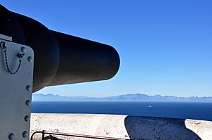
The famous naval base of Simon's Town is in Simon's Bay, about halfway down the length of the False Bay coast of the Cape Peninsula. During the Second World War many heavy guns were mounted in concrete bunkers at various points along the mountainous shores of False Bay in order to deter attacks on Simon's Town. The firepower and defensive situation of these weapons were formidable and no attack was ever mounted. Although some of the guns were removed decades ago a few large guns are still emplaced on the hillsides near the Redhill road. Lower North battery at the bottom of Redhill road is used for naval gunnery training and has a few examples of currently used weapon systems for this purpose.
Images for kids
See also
 In Spanish: Bahía Falsa para niños


