Englishtown, New Jersey facts for kids
Quick facts for kids
Englishtown, New Jersey
|
||
|---|---|---|
|
Borough
|
||
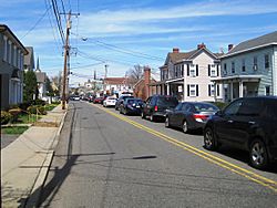
Looking north along Main Street (CR 527) away from Tennent Avenue (CR 522)
|
||
|
||
| Motto(s):
History, Harmony, and Hospitality
|
||
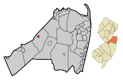
Location of Englishtown in Monmouth County highlighted in red (left). Inset map: Location of Monmouth County in New Jersey highlighted in orange (right).
|
||
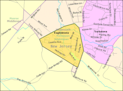
Census Bureau map of Englishtown, New Jersey
|
||
| Country | ||
| State | ||
| County | Monmouth | |
| Incorporated | January 4, 1888 | |
| Named for | James English | |
| Government | ||
| • Type | Borough | |
| • Body | Borough Council | |
| Area | ||
| • Total | 0.59 sq mi (1.52 km2) | |
| • Land | 0.57 sq mi (1.48 km2) | |
| • Water | 0.02 sq mi (0.04 km2) 2.88% | |
| Area rank | 543rd of 565 in state 46th of 53 in county |
|
| Elevation | 69 ft (21 m) | |
| Population
(2020)
|
||
| • Total | 2,346 | |
| • Estimate
(2023)
|
2,342 | |
| • Rank | 474th of 565 in state 41st of 53 in county |
|
| • Density | 4,117.0/sq mi (1,589.6/km2) | |
| • Density rank | 152nd of 565 in state 16th of 53 in county |
|
| Time zone | UTC−05:00 (Eastern (EST)) | |
| • Summer (DST) | UTC−04:00 (Eastern (EDT)) | |
| ZIP Code |
07726
|
|
| Area code(s) | 732 exchanges: 446, 536, 591, 617, 786, 792, 970 | |
| FIPS code | 3402521570 | |
| GNIS feature ID | 0885211 | |
| Website | ||
Englishtown is a rapidly growing borough in western Monmouth County, in the U.S. state of New Jersey. The community is located within the Raritan Valley region. As of the 2020 United States census, the borough's population was 2,346, its highest decennial count ever and an increase of 499 (+27.0%) from the 2010 census count of 1,847, which in turn reflected an increase of 83 (+4.7%) from the 1,764 counted in the 2000 census.
Englishtown was incorporated as a borough by an act of the New Jersey Legislature on January 4, 1888, from portions of Manalapan Township, based on the results of a referendum held the previous day. The borough was named for James English, an early settler.
Contents
History
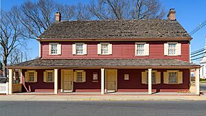
At the Battle of Monmouth, an American Revolutionary War battle fought on June 28, 1778, in Monmouth County, American General Charles Lee led the advance and initiated the first attack on the column's rear. When the British turned to flank him, he ordered a general retreat without as much as firing a shot at the enemy, and his soldiers soon became disorganized. General George Washington continued the battle, earning respect for the Continental Army troops under his command. In the dining room of the Village Inn, located in the center of Englishtown, General Washington and Lord Stirling drew up the court martial papers citing Lee for his conduct during and after the battle.
Geography
According to the United States Census Bureau, the borough had a total area of 0.59 square miles (1.52 km2), including 0.57 square miles (1.48 km2) of land and 0.02 square miles (0.04 km2) of water (2.88%).
The borough is entirely surrounded by Manalapan Township, making it part of 21 pairs of "doughnut towns" in the state, where one municipality entirely surrounds another.
Demographics
| Historical population | |||
|---|---|---|---|
| Census | Pop. | %± | |
| 1890 | 444 | — | |
| 1900 | 410 | −7.7% | |
| 1910 | 468 | 14.1% | |
| 1920 | 641 | 37.0% | |
| 1930 | 797 | 24.3% | |
| 1940 | 815 | 2.3% | |
| 1950 | 1,004 | 23.2% | |
| 1960 | 1,143 | 13.8% | |
| 1970 | 1,048 | −8.3% | |
| 1980 | 976 | −6.9% | |
| 1990 | 1,268 | 29.9% | |
| 2000 | 1,764 | 39.1% | |
| 2010 | 1,847 | 4.7% | |
| 2020 | 2,346 | 27.0% | |
| 2023 (est.) | 2,342 | 26.8% | |
| Population sources: 1890–1920 1890–1910 1910–1930 1940–2000 2000 2010 2020 |
|||
2010 census
The 2010 United States census counted 1,847 people, 621 households, and 458 families in the borough. The population density was 3,245.7 per square mile (1,253.2/km2). There were 647 housing units at an average density of 1,137.0 per square mile (439.0/km2). The racial makeup was 88.14% (1,628) White, 2.60% (48) Black or African American, 0.00% (0) Native American, 6.82% (126) Asian, 0.11% (2) Pacific Islander, 0.92% (17) from other races, and 1.41% (26) from two or more races. Hispanic or Latino of any race were 8.01% (148) of the population.
Of the 621 households, 40.6% had children under the age of 18; 55.1% were married couples living together; 14.3% had a female householder with no husband present and 26.2% were non-families. Of all households, 20.5% were made up of individuals and 5.3% had someone living alone who was 65 years of age or older. The average household size was 2.84 and the average family size was 3.33.
25.5% of the population were under the age of 18, 8.3% from 18 to 24, 27.2% from 25 to 44, 28.9% from 45 to 64, and 10.1% who were 65 years of age or older. The median age was 38.6 years. For every 100 females, the population had 93.4 males. For every 100 females ages 18 and older there were 90.1 males.
The Census Bureau's 2006–2010 American Community Survey showed that (in 2010 inflation-adjusted dollars) median household income was $70,795 (with a margin of error of +/− $8,336) and the median family income was $86,484 (+/− $8,333). Males had a median income of $65,625 (+/− $10,588) versus $43,333 (+/− $8,417) for females. The per capita income for the borough was $30,313 (+/− $2,456). About 1.5% of families and 2.3% of the population were below the poverty line, including 4.1% of those under age 18 and 5.4% of those age 65 or over.
Education
Public school students in pre-kindergarten through eighth grade attend the Manalapan-Englishtown Regional School District, which also serves children from Manalapan Township. Manalapan and Englishtown formally joined together as a regional elementary school district in 1963, with an initial enrollment of 1,140 students; The student body is primarily from Manalapan Township, which accounts for about 95% of enrollment, with Englishtown students accounting for the remaining 5%. As of the 2019–20 school year, the district, comprised of eight schools, had an enrollment of 4,910 students and 408.4 classroom teachers (on an FTE basis), for a student–teacher ratio of 12.0:1. Schools in the district (with 2019–20 enrollment from the National Center for Education Statistics) are John I. Dawes Early Learning Center with 365 students in Pre-K and K, Clark Mills School with 491 students in grades 1–5, Lafayette Mills School with 489 students in grades 1–5, Milford Brook School with 523 students in grades K–5, Taylor Mills School with 600 students in grades K–5, Wemrock Brook School with 626 students in grades 1–5, Pine Brook School with 563 students in sixth grade and Manalapan-Englishtown Middle School with 1,227 students in grades 7 and 8. The district is overseen by a nine-member board of education, which sets policy and oversees the fiscal and educational operation of the district; Seats on the board are allocated based on population, with one seat assigned to Englishtown.
Students from Englishtown in public school for ninth through twelfth grades attend Manalapan High School as part of the Freehold Regional High School District (FRHSD). The Freehold Regional High School District also serves students from Colts Neck Township, Englishtown, Farmingdale, Freehold Borough, Freehold Township, Howell Township and Marlboro Township. As of the 2019–20 school year, Manalapan High School had an enrollment of 1,879 students and 122.8 classroom teachers (on an FTE basis), for a student–teacher ratio of 15.3:1. Students may apply to attend one of the district's six specialized learning centers, including the Science and Engineering Learning Center hosted at Manalapan High School. The FRHSD board of education has nine members, who are elected to three-year terms from each of the constituent districts. Each member is allocated a fraction of a vote that totals to nine points, with Englishtown allocated one member, who has 0.5 votes.
Public high school students also have the option of attending one of the Monmouth County Vocational School District's five career academies.
Transportation
Roads and highways
As of May 2010[update], the borough had a total of 6.42 miles (10.33 km) of roadways, of which 4.44 miles (7.15 km) were maintained by the municipality and 1.98 miles (3.19 km) by Monmouth County.
County Route 522 (Wood Avenue) and County Route 527 are the most prominent roads directly serving the borough.
Public transportation
In the 19th and 20th centuries, Englishtown Borough and Manalapan Township had a major railway in the area, which was the Freehold and Jamesburg Agricultural Railroad. This railway was owned and operated by the Camden & Amboy Railroad Company (C&A), in which surveying for the line began on September 8, 1851, grading began on October 19, 1852, and the first track was laid on April 4, 1853. The first section of line was opened on July 18, 1853. The establishment of the Freehold & Jamesburg Agricultural Railroad allowed this region to become a transportation hub. The Freehold and Jamesburg Railroad was abandoned by the early 1930s. A 2.8-mile long (4.5 km) portion of the former railroad's right-of-way was later approved to be sold by the New Jersey Board of Public Utility Commissioners (PUC) to Jersey Central Power & Light Company in 1966, with occasional freight service still being utilized through the Freehold Industrial Track.
NJ Transit offers bus service between Englishtown and the Port Authority Bus Terminal in Midtown Manhattan, which is available on the 139 route.
Old Bridge Airport and Mar Bar L Farms municipal airport are within 2+1⁄2 miles (4.0 km) of Englishtown, offering short-distance flights to surrounding areas.
Points of interest
Notable people
People who were born in, residents of, or otherwise closely associated with Englishtown include:
- Robby Andrews (born 1991), middle-distance runner
- Deborah Berger (1956–2005), artist noted for her oeuvre of brightly colored textile works created in knitting and crochet
- Lou Brutus (born 1962), radio host, musician and photographer
- Dov Davidoff (born 1973), stand-up comedian
- Anthony Firkser (born 1995), professional football tight end for the Kansas City Chiefs of the National Football League
- Ed Krawiec (born 1976), NHRA Pro Stock Motorcycle racer
- Abhimanyu Mishra (born 2009), chess grandmaster and prodigy
- Alan Veingrad (born 1963), former American football offensive lineman who played in the National Football League for the Green Bay Packers and Dallas Cowboys
See also
 In Spanish: Englishtown para niños
 | Calvin Brent |
 | Walter T. Bailey |
 | Martha Cassell Thompson |
 | Alberta Jeannette Cassell |


