Eatontown, New Jersey facts for kids
Quick facts for kids
Eatontown, New Jersey
|
||
|---|---|---|
|
Borough
|
||
|
|
||
|
||

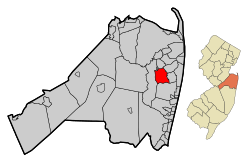
Location of Eatontown in Monmouth County highlighted in red (left). Inset map: Location of Monmouth County in New Jersey highlighted in orange (right).
|
||

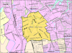
Census Bureau map of Eatontown, New Jersey
|
||
| Country | ||
| State | ||
| County | Monmouth | |
| Incorporated | April 4, 1873 as township | |
| Incorporated | March 8, 1926 as borough | |
| Named for | Thomas Eaton | |
| Government | ||
| • Type | Borough | |
| • Body | Borough Council | |
| Area | ||
| • Total | 5.89 sq mi (15.26 km2) | |
| • Land | 5.84 sq mi (15.13 km2) | |
| • Water | 0.05 sq mi (0.13 km2) 0.87% | |
| Area rank | 260th of 565 in state 18th of 53 in county |
|
| Elevation | 52 ft (16 m) | |
| Population
(2020)
|
||
| • Total | 13,597 | |
| • Estimate
(2023)
|
13,496 | |
| • Rank | 190th of 565 in state 15th of 53 in county |
|
| • Density | 2,327.9/sq mi (898.8/km2) | |
| • Density rank | 266th of 565 in state 32nd of 53 in county |
|
| Time zone | UTC−05:00 (Eastern (EST)) | |
| • Summer (DST) | UTC−04:00 (Eastern (EDT)) | |
| ZIP Codes |
07724, 07799
|
|
| Area code(s) | 732 | |
| FIPS code | 3402519840 | |
| GNIS feature ID | 0885202 | |
Eatontown is a borough in Monmouth County, in the U.S. state of New Jersey. As of the 2020 United States census, the borough's population was 13,597, an increase of 888 (+7.0%) from the 2010 census count of 12,709, which in turn reflected a decline of 1,299 (−9.3%) from the 14,008 counted in the 2000 census.
The community that is now Eatontown was originally incorporated as Eatontown Township by an act of the New Jersey Legislature on April 4, 1873, from portions of Ocean Township and Shrewsbury Township. Portions of the township were taken to form West Long Branch (April 7, 1908) and Oceanport (April 6, 1920). Eatontown was reincorporated as a borough on March 8, 1926, replacing Eatontown Township, based on the results of a referendum held on April 13, 1926. The borough was named for Thomas Eaton, an early settler who built a mill c. 1670.
The United States Army's Fort Monmouth operated in Eatontown from 1917 until its closure in September 2011, based on recommendations from the Base Realignment and Closure Commission. It was home to the United States Army Materiel Command's (AMC) Communication and Electronics Command (CECOM). Fort Monmouth was also home to the United States Military Academy Preparatory School (or USMAPS), which trains approximately 250 students per year to enter as freshmen (plebes) at the United States Military Academy at West Point.
In the center of Eatontown is the Monmouth Mall, located at the intersection of Route 35 and Route 36, featuring a variety of stores, restaurants, and a 15-screen cineplex, with a gross leasable area of 1,500,000 square feet (140,000 m2). Celebrity chef Bobby Flay previously owned a restaurant in Eatontown.
Contents
History
Eatontown's history is documented in the book Eatontown and Fort Monmouth.
In 1670, Thomas Eaton (for which the town is named) surveyed the area and constructed a grist mill in present-day Wampum Lake Park.
In 2020, Eatontown was to celebrate its 350th anniversary, but most of the activities were delayed due to COVID-19 concerns.
Geography
According to the United States Census Bureau, the borough had a total area of 5.89 square miles (15.26 km2), including 5.84 square miles (15.13 km2) of land and 0.05 square miles (0.13 km2) of water (0.87%).
The Unincorporated community of Locust Grove is located within the borough.
The borough borders the Monmouth County municipalities of Shrewsbury on the north, Oceanport to the northeast, West Long Branch to the east, Ocean Township to the south and Tinton Falls to the west.
Demographics
| Historical population | |||
|---|---|---|---|
| Census | Pop. | %± | |
| 1880 | 2,642 | — | |
| 1890 | 2,953 | 11.8% | |
| 1900 | 3,021 | 2.3% | |
| 1910 | 2,076 | −31.3% | |
| 1920 | 2,682 | 29.2% | |
| 1930 | 1,938 | −27.7% | |
| 1940 | 1,758 | −9.3% | |
| 1950 | 3,044 | 73.2% | |
| 1960 | 10,334 | 239.5% | |
| 1970 | 14,619 | 41.5% | |
| 1980 | 12,703 | −13.1% | |
| 1990 | 13,800 | 8.6% | |
| 2000 | 14,008 | 1.5% | |
| 2010 | 12,709 | −9.3% | |
| 2020 | 13,597 | 7.0% | |
| 2023 (est.) | 13,496 | 6.2% | |
| Population sources: 1880–1920 1880–1890 1890–1910 1910–1930 1940–2000 2000 2010 2020 |
|||
2010 census
The 2010 United States census counted 12,709 people, 5,319 households, and 3,138 families in the borough. The population density was 2,181.5 per square mile (842.3/km2). There were 5,723 housing units at an average density of 982.3 per square mile (379.3/km2). The racial makeup was 71.29% (9,060) White, 12.41% (1,577) Black or African American, 0.28% (36) Native American, 8.67% (1,102) Asian, 0.09% (11) Pacific Islander, 3.64% (463) from other races, and 3.62% (460) from two or more races. Hispanic or Latino of any race were 12.36% (1,571) of the population.
Of the 5,319 households, 26.3% had children under the age of 18; 41.2% were married couples living together; 13.4% had a female householder with no husband present and 41.0% were non-families. Of all households, 34.2% were made up of individuals and 11.6% had someone living alone who was 65 years of age or older. The average household size was 2.32 and the average family size was 3.02.
20.7% of the population were under the age of 18, 9.3% from 18 to 24, 27.5% from 25 to 44, 28.5% from 45 to 64, and 14.0% who were 65 years of age or older. The median age was 39.6 years. For every 100 females, the population had 97.2 males. For every 100 females ages 18 and older there were 93.4 males.
The Census Bureau's 2006–2010 American Community Survey showed that (in 2010 inflation-adjusted dollars) median household income was $60,188 (with a margin of error of +/− $8,468) and the median family income was $77,846 (+/− $8,290). Males had a median income of $56,086 (+/− $7,155) versus $43,750 (+/− $5,817) for females. The per capita income for the borough was $35,200 (+/− $2,933). About 6.4% of families and 9.1% of the population were below the poverty line, including 12.7% of those under age 18 and 5.4% of those age 65 or over.
Education
Students in public school for pre-kindergarten through eighth grade attend the Eatontown Public Schools. The district includes three elementary schools and a middle school. As of the 2022–23 school year, the district, comprised of four schools, had an enrollment of 980 students and 98.9 classroom teachers (on an FTE basis), for a student–teacher ratio of 9.9:1. Schools in the district (with 2022–23 enrollment data from the National Center for Education Statistics) are Meadowbrook Elementary School with 235 students in grades PreK–1, Woodmere Elementary School with 323 students in grades PreK / 2–4, Margaret L. Vetter Elementary School with 222 students in grades PreK / 5–6 and Memorial Middle School with 178 students in grades 7–8.
Public school students in ninth through twelfth grades attend Monmouth Regional High School, located in Tinton Falls. The high school is part of the Monmouth Regional High School District, which also serves students from Shrewsbury Township and Tinton Falls. As of the 2022–23 school year, the high school had an enrollment of 938 students and 93.1 classroom teachers (on an FTE basis), for a student–teacher ratio of 10.1:1. Seats on the nine-member board of education for the high school district are allocated based on the population of the constituent municipalities, with three seats allocated to Eatontown.
Eatontown is also home to Hawkswood School, a school founded in 1976 that serves the educational needs of disabled students in the area "with complex, multiple disabilities, including autism".
Transportation
Roads and highways

As of May 2010[update], the borough had a total of 50.45 miles (81.19 km) of roadways, of which 36.84 miles (59.29 km) were maintained by the municipality, 5.82 miles (9.37 km) by Monmouth County and 7.79 miles (12.54 km) by the New Jersey Department of Transportation.
Several state highways pass through Eatontown. These include the freeway portion of Route 18 in the southwestern part of the borough, Route 35 and Route 36 in the center of the borough, and Route 71 in the north. Major county roads that pass through Eatontown include CR 537 and CR 547.
The Garden State Parkway, the largest highway in Monmouth County, is accessible just outside the borough in neighboring Tinton Falls at exit 105.
Public transportation
NJ Transit provides local bus transportation on the 831 and 832 routes.
Complete Streets
Created in May 2018, the goal of the Eatontown Complete Streets Advisory Committee is to establish a walkable and bikeable community that is safe and accessible for people of all ages and abilities.
Notable people
People who were born in, residents of, or otherwise closely associated with Eatontown include:
- Preet Bharara (born 1968), former United States Attorney for the Southern District of New York
- Charles W. Billings (1866–1928), politician and competitive shooter who was a member of the 1912 Summer Olympics American trapshooting team that won the gold medal in team clay pigeons
- Joe Bravo (born 1971), thoroughbred horse racing jockey
- Herm Edwards (born 1954), football analyst and former NFL head coach
- June Elvidge (1893–1965), film actress
- Houston Fields (1861–1899), sheriff of Monmouth County
- Liati Mayk-Hai (born 1981) singer-songwriter, visual artist, poet and athlete
- Melissa Reeves (born 1967), actress who has played the role of Jennifer Horton on Days of Our Lives since 1985
- Kevin Ritz (born 1965), former MLB pitcher who played for the Detroit Tigers and Colorado Rockies
- Cindy Lee Van Dover (born 1954), oceanographer, who also studies biodiversity, biogeochemistry, conservation biology, ecology and marine science
- Anthony M. Villane (1929–2022), dentist and politician, who served in the New Jersey General Assembly from 1976 to 1988
- Peter Vredenburgh Jr. (1837–1864), lawyer and Union Army major
See also
 In Spanish: Eatontown para niños


