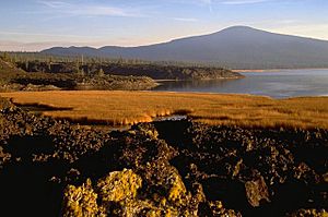
Davis Lake volcanic field facts for kids
Quick facts for kids Davis Lake volcanic field |
|
|---|---|
 |
|
| Location | Deschutes / Klamath counties, Oregon, U.S. |
| Range | Cascades |
| Highest point – elevation – coordinates |
Hamner Butte 7,103 ft (2,165 m) 43°33′33″N 121°48′46″W / 43.559258250°N 121.812858139°W |
| Geology | Cinder cone, Lava flow, and shield volcano |
| Age | Holocene |
| Volcanic arc | Cascade Volcanic Arc |
| Last eruption | 2790 BC (?) |
The Davis Lake volcanic field, is a volcanic field with a group of andesitic cinder cones, lava flows and basaltic andesite shield volcano. The field is located east of the Cascade Range of Oregon, United States.
Notable vents
| Name | Elevation | Coordinates |
| Cryder Butte | 5,479 ft (1,670 m) | 43°33′49″N 121°43′02″W / 43.5637340°N 121.7172483°W |
| Davis Mountain | 6,624 ft (2,019 m) | 43°37′45″N 121°46′00″W / 43.6292878°N 121.7666941°W |
| Hamner Butte | 7,103 ft (2,165 m) | 43°33′33″N 121°48′46″W / 43.559258250°N 121.812858139°W |
| Little Odell Butte | 5,541 ft (1,689 m) | 43°26′37″N 121°54′17″W / 43.4437368°N 121.9047501°W |
| Odell Butte | 7,011 ft (2,137 m) | 43°28′15″N 121°51′50″W / 43.4709584°N 121.8639165°W |
| Pine Butte | 5,240 ft (1,597 m) | 43°39′41″N 121°50′43″W / 43.6615099°N 121.8453067°W |
| Ringo Butte | 6,079 ft (1,853 m) | 43°32′59″N 121°45′18″W / 43.5498453°N 121.7550265°W |
| Royce Mountain | 6,148 ft (1,874 m) | 43°31′11″N 121°54′08″W / 43.5198466°N 121.9022509°W |

All content from Kiddle encyclopedia articles (including the article images and facts) can be freely used under Attribution-ShareAlike license, unless stated otherwise. Cite this article:
Davis Lake volcanic field Facts for Kids. Kiddle Encyclopedia.
