Cuyahoga County, Ohio facts for kids
Quick facts for kids
Cuyahoga County
|
|||
|---|---|---|---|

|
|||
|
|||
| Etymology: Cuyahoga River | |||

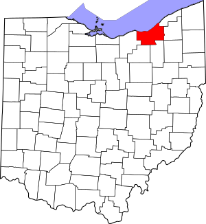
Map of Cuyahoga County within Ohio
|
|||
| Country | United States | ||
| State | Ohio | ||
| Region | Northeast Ohio | ||
| Founded | May 1, 1810 | ||
| Named for | Cuyahoga River | ||
| County seat | Cleveland | ||
| Area | |||
| • Total | 1,246 sq mi (3,230 km2) | ||
| • Land | 457 sq mi (1,180 km2) | ||
| • Water | 788 sq mi (2,040 km2) | ||
| Elevation | 653 ft (199 m) | ||
| Population
(2020)
|
|||
| • Total | 1,264,817 | ||
| • Estimate
(2023)
|
1,233,088 |
||
| • Density | 2,768/sq mi (1,069/km2) | ||
| Gross Domestic Product | |||
| • Total | US$104.292 billion (2022) | ||
| Time zone | UTC−5 (EST) | ||
| • Summer (DST) | UTC−4 (EDT) | ||
| Area code(s) | 216 | ||
| Congressional districts | 7th, 11th | ||
| Largest city | Cleveland | ||
Cuyahoga County (/ˌkaɪ.əˈhɒɡə/ KY-ə-HOG-ə or /ˌkaɪ.əˈhoʊɡə/ KY-ə-HOH-gə) is a large urban county located in the northeastern part of the U.S. state of Ohio. The county seat and largest city is Cleveland. As of the 2020 census, its population was 1,264,817, making it the second-most populous county in the state.
Cuyahoga County is situated on the southern shore of Lake Erie, across the U.S.–Canada maritime border. The county is bisected by the Cuyahoga River, after which it was named. "Cuyahoga" is an Iroquoian word meaning "crooked river". It is the core county of the Cleveland, OH Metropolitan Statistical Area and Cleveland–Akron–Canton, OH Combined Statistical Area.
Contents
History
The land that became Cuyahoga County was previously part of the French colony of Canada (New France), which was ceded in 1763 to Great Britain and renamed Province of Quebec. In the early 1790s, the land became part of the Connecticut Western Reserve in the Northwest Territory, and it was purchased by the Connecticut Land Company in 1795. Cleveland was established one year later by General Moses Cleaveland near the mouth of the Cuyahoga River.
Cuyahoga County was created on June 7, 1807, and organized on May 1, 1810. Cleveland (then known as "Cleaveland") was selected as the county seat in 1809. The county was later reduced in size by the creation of Huron, Lake, and Lorain counties.
In 1831, future U.S. President James A. Garfield was born in what was at the time Cuyahoga County's Orange Township.
Geography
According to the United States Census Bureau, the county has an area of 1,246 sq mi (3,230 km2), of which 457 sq mi (1,180 km2) are land and 788 sq mi (2,040 km2) (63%) are water. It is the second-largest county in Ohio by area. A portion of Cuyahoga Valley National Park is in the county's southeastern section.
Adjacent counties
- Lake County (northeast)
- Geauga County (east)
- Summit County (southeast)
- Medina County (southwest)
- Lorain County (west)
- Portage County (southeast)
Demographics
| Historical population | |||
|---|---|---|---|
| Census | Pop. | %± | |
| 1810 | 1,459 | — | |
| 1820 | 6,328 | 333.7% | |
| 1830 | 10,373 | 63.9% | |
| 1840 | 26,506 | 155.5% | |
| 1850 | 48,099 | 81.5% | |
| 1860 | 78,033 | 62.2% | |
| 1870 | 132,010 | 69.2% | |
| 1880 | 196,943 | 49.2% | |
| 1890 | 309,970 | 57.4% | |
| 1900 | 439,120 | 41.7% | |
| 1910 | 637,425 | 45.2% | |
| 1920 | 943,495 | 48.0% | |
| 1930 | 1,201,455 | 27.3% | |
| 1940 | 1,217,250 | 1.3% | |
| 1950 | 1,389,532 | 14.2% | |
| 1960 | 1,647,895 | 18.6% | |
| 1970 | 1,721,300 | 4.5% | |
| 1980 | 1,498,400 | −12.9% | |
| 1990 | 1,412,140 | −5.8% | |
| 2000 | 1,393,978 | −1.3% | |
| 2010 | 1,280,122 | −8.2% | |
| 2020 | 1,264,817 | −1.2% | |
| 2023 (est.) | 1,233,088 | −3.7% | |
| U.S. Decennial Census 1790-1960 1900–1990 1990–2000 2010–2020 |
|||
2020 census
| Race | Number | Percent |
|---|---|---|
| White (NH) | 718,753 | 56.8% |
| Black or African American (NH) | 365,169 | 28.9% |
| Native American (NH) | 1,827 | 0.1% |
| Asian (NH) | 43,739 | 3.5% |
| Pacific Islander (NH) | 249 | 0.0% |
| Some Other Race (NH) | 5,745 | 0.5% |
| Mixed/Multi-Racial (NH) | 46,008 | 3.6% |
| Hispanic or Latino | 83,327 | 6.6% |
| Total | 1,264,817 | 100.0% |
As of the 2020 census, there were 1,264,817 people, 555,988 households, and 309,691 families residing in the county. The population density was 2,766.4 inhabitants per square mile (1,068.1/km2). There were 615,825 housing units. The racial makeup of the county was 58.2% White, 29.3% African American, 0.2% Native American, 3.5% Asian, 0.0% Pacific Islander, 2.8% from some other races and 5.9% from two or more races. Hispanic or Latino of any race were 6.6% of the population. 20.3% of residents were under the age of 18, 5.3% were under 5 years of age, and 19.6% were 65 and older.
2010 census
| Largest ancestries (2010) | Percent |
|---|---|
| German | 17.4% |
| Irish | 13.0% |
| Italian | 9.2% |
| Polish | 8.6% |
| English | 6.3% |
| Slovak | 3.3% |

As of the 2010 census, there were 1,280,122 people, 571,457 households, and 319,996 families were residing in the county. The population density was 2,800.0 people/sq mi (1,081.1 people/km2). The 621,763 housing units averaged 1,346 units per square mile (520 units/km2). The racial makeup of the county was 63.6% White, 29.7% African American, 0.2% Native American, 2.6% Asian (0.9% Indian, 0.7% Chinese, 0.3% Filipino, 0.2% Korean, 0.2% Vietnamese, 0.1% Japanese), 1.8% from other races, and 2.1% from two or more races. About 4.8% of the population were Hispanics or Latinos of any race (3.1% Puerto Rican, 0.7% Mexican, 0.1% Dominican, 0.1% Guatemalan). Further, 16.5% were of German, 12.8% Irish, 8.8% Italian, 8.1% Polish, 5.9% English, 3.7% Slovak, and 3.1% Hungarian heritage.
Sizable numbers of Russians (1.7%), French, (1.4%), Arabs (1.4%), Ukrainians (1.2%), and Greeks (0.7%) were residing in the county; as their first language, 88.4% spoke English, 3.7% Spanish, and 4.9% some other Indo-European language. In addition, 7.3% of the population were foreign-born (of which 44.4% were born in Europe, 36.3% in Asia, and 12.1% in Latin America).
Of the 571,457 households, 28.5% had children under 18 living with them, 42.4% were married couples living together, 15.7% had a female householder with no husband present, and 37.9% were not families. About 32.8% of all households consisted of single individuals, and 12.1% consisted of someone living alone who was 65 or older. The average household size was 2.39, and the average family size was 3.06.
The age distribution in the county was as follows: 25.0% under 18, 8.0% between 18 and 24, 29.3% between 25 and 44, 22.2% between 45 and 64, and 15.6% who were 65 or older. The median age was 37 years old. For every 100 females, there were 89.5 males. For every 100 females age 18 and over, there were 85.2 males.
The median income in the county was $43,603 for a household and $58,631 and for a family. The county's per capita income was $26,263. About 10.3% of families, 19.4% of those under age 18, and 9.3% of those age 65 or over, and 13.1% of the population as a whole was living below the poverty line.
Education
Colleges and universities
Cuyahoga County is home to a number of higher-education institutions, including:
- Baldwin Wallace University (Berea)
- Bryant and Stratton College (Parma)
- Cleveland Bartending School (Cleveland Heights)
- Case Western Reserve University (Cleveland)
- Cleveland Institute of Art (Cleveland)
- Cleveland Institute of Music (Cleveland)
- Cleveland State University (Cleveland)
- Cuyahoga Community College (Cleveland, Highland Hills, Westlake, and Parma)
- DeVry University (Seven Hills)
- John Carroll University (University Heights)
- Kent State University College of Podiatric Medicine (Independence)
- Stautzenberger College (Brecksville)
- Ursuline College (Pepper Pike)
K-12 education
School districts include:
- Bay Village City School District
- Beachwood City School District
- Bedford City School District
- Berea City School District
- Brecksville-Broadview Heights City School District
- Brooklyn City School District
- Chagrin Falls Exempted Village School District
- Cleveland Municipal School District
- Cleveland Heights-University Heights City School District
- Cuyahoga Heights Local School District
- East Cleveland City School District
- Euclid City School District
- Fairview Park City School District
- Garfield Heights City School District
- Independence Local School District
- Lakewood City School District
- Maple Heights City School District
- Mayfield City School District
- North Olmsted City School District
- North Royalton City School District
- Olmsted Falls City School District
- Orange City School District
- Parma City School District
- Rocky River City School District
- Richmond Heights Local School District
- Shaker Heights City School District
- Solon City School District
- South Euclid-Lyndhurst City School District
- Strongsville City School District
- Warrensville Heights City School District
- Westlake City School District
Transportation
Airports
Cuyahoga County is served by international, regional, and county airports, including:
- Cuyahoga County Airport
- Cleveland Hopkins International Airport (Cleveland)
- Cleveland Burke Lakefront Airport (Cleveland)
Major highways
 I-71
I-71 I-77
I-77
 I-80 / Ohio Turnpike
 I-90
I-90 I-271
I-271 I-480
I-480 I-480N
 I-490
I-490 US 6
US 6 US 20
US 20 US 42
US 42 US 322
 US 422
 SR 2
SR 2 SR 3
SR 3 SR 8
SR 8 SR 10
SR 10 SR 14
SR 14 SR 21
SR 21 SR 43
SR 43 SR 82
SR 82 SR 87
SR 87 SR 91
SR 91 SR 94
SR 94 SR 174
 SR 175
 SR 176
 SR 237
 SR 252
 SR 254
 SR 283
 SR 291
Rail
Cuyahoga County receives intercity passenger service by Amtrak by way of Lakefront Station in Cleveland, with destinations such as Chicago, New York, Boston, Washington, DC, and many more.
The Cuyahoga Valley Scenic Railroad offers scenic excursion service through the Cuyahoga Valley National Park by way of their Rockside Station in Independence.
Freight rail service is provided by Norfolk Southern, CSX Transportation, Wheeling and Lake Erie Railroad, Cleveland Commercial Railroad, and several other small companies. Norfolk Southern has the largest presence in the county, operating three different lines and several terminal yards.
Public transportation
The Greater Cleveland Regional Transit Authority, also known as RTA, provides public transportation to Cuyahoga County through a combination of conventional bus, rapid-transit bus, and rail transit services, as well as on-demand services. Several other county agencies also serve Cuyahoga County, mostly through downtown Cleveland.
Greyhound, Barons Bus Lines, and Megabus provide public transportation beyond Cuyahoga County to destinations across the United States.
Recreation
The Cleveland Metroparks system serves Cuyahoga County. Its 16 reservations provide more than 21,000 acres (8,500 ha) of green space and recreational amenities. The county is home to part of Cuyahoga Valley National Park, which extends southward into Summit County.
Culture
Theaters
- Beck Center (Lakewood)
- Cabaret Dada (Cleveland)
- Cassidy Theater (Parma Heights)
- Cleveland Play House (Cleveland)
- Cleveland Public Theater (Cleveland)
- Dobama Theater (Cleveland Heights)
- East Cleveland Theater (East Cleveland)
- Huntington Playhouse (Bay Village)
- Karamu House (Cleveland)
- Near West Theatre (Cleveland)
- Playhouse Square Center (Cleveland)
Classical music
- Cleveland Orchestra performs in Severance Hall
Museums
- Cleveland Museum of Art
- Museum of Contemporary Art, Cleveland
- Rock and Roll Hall of Fame
- Cleveland Museum of Natural History
- Maltz Museum of Jewish Heritage, Beachwood
- Great Lakes Science Center, Cleveland
- International Women Air and Space Museum Cleveland
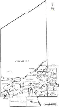
Communities
Cities
- Bay Village
- Beachwood
- Bedford
- Bedford Heights
- Berea
- Brecksville
- Broadview Heights
- Brook Park
- Brooklyn
- Cleveland (county seat)
- Cleveland Heights
- East Cleveland
- Euclid
- Fairview Park
- Garfield Heights
- Highland Heights
- Independence
- Lakewood
- Lyndhurst
- Maple Heights
- Mayfield Heights
- Middleburg Heights
- North Olmsted
- North Royalton
- Olmsted Falls
- Parma
- Parma Heights
- Pepper Pike
- Richmond Heights
- Rocky River
- Seven Hills
- Shaker Heights
- Solon
- South Euclid
- Strongsville
- University Heights
- Warrensville Heights
- Westlake
Villages
Townships
- Chagrin Falls
- Olmsted
- Nineteen paper townships
See also
 In Spanish: Condado de Cuyahoga para niños


