County of Flinders, Queensland facts for kids
Quick facts for kids FlindersQueensland |
|||||||||||||||
|---|---|---|---|---|---|---|---|---|---|---|---|---|---|---|---|

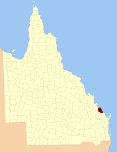
Location within Queensland
|
|||||||||||||||
|
|||||||||||||||
The County of Flinders is a county (a cadastral division) in Queensland, Australia, located in the Central Queensland region between Gladstone and Bundaberg. The county is divided into civil parishes. It was named for Matthew Flinders who explored the Australian coastline.
The county was created on 1 September 1855 by royal proclamation under the Waste Lands Australia Act 1846. On 7 March 1901, the Governor issued a proclamation legally dividing Queensland into counties under the Land Act 1897. Its schedule described Flinders thus:
Bounded on the south by the counties of Cook and Bowen; on the west by the county of Yarrol, the eastern watershed of the Boyne River, and the western boundary of the parist of Rodds Bay; and on the north and east by the Pacific Ocean.
Parishes
Flinders is divided into parishes, as listed below:
| Parish | LGA | Coordinates | Towns |
|---|---|---|---|
| Arthurs Seat | Gladstone | 24°17′S 151°42′E / 24.283°S 151.700°E | |
| Baffle | Gladstone | 24°28′S 151°57′E / 24.467°S 151.950°E | |
| Bulburin | Gladstone | 24°32′S 151°34′E / 24.533°S 151.567°E | |
| Bunker | Gladstone | 23°46′S 152°22′E / 23.767°S 152.367°E | |
| Euleilah | Gladstone | 24°31′S 151°50′E / 24.517°S 151.833°E | |
| Eurimbula | Gladstone | 24°07′S 151°43′E / 24.117°S 151.717°E | Town of 1770 |
| Littabella | Bundaberg | 24°40′S 152°05′E / 24.667°S 152.083°E | Watalgan |
| Miriam Vale | Gladstone | 24°22′S 151°35′E / 24.367°S 151.583°E | Miriam Vale |
| Polmaily | Gladstone | 24°20′S 151°29′E / 24.333°S 151.483°E | Bororen |
| Rodds Bay | Gladstone | 24°06′S 151°32′E / 24.100°S 151.533°E | |
| Rosedale | Gladstone | 24°41′S 151°51′E / 24.683°S 151.850°E | Rosedale (S) |
| Taunton | Gladstone | 24°24′S 151°44′E / 24.400°S 151.733°E | |
| Thornhill | Gladstone | 24°39′S 151°36′E / 24.650°S 151.600°E | |
| Tottenham | Gladstone | 24°36′S 151°59′E / 24.600°S 151.983°E | Rosedale (N) |
| Uxbridge | Gladstone | 24°19′S 151°53′E / 24.317°S 151.883°E | Agnes Water |
| Warro | Gladstone | 24°33′S 151°44′E / 24.550°S 151.733°E | Lowmead |
External links

