County of Clive, Queensland facts for kids
Quick facts for kids CliveQueensland |
|||||||||||||||
|---|---|---|---|---|---|---|---|---|---|---|---|---|---|---|---|

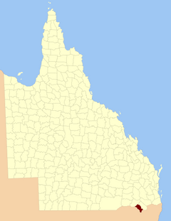
Location within Queensland
|
|||||||||||||||
|
|||||||||||||||
The County of Clive is a county (a cadastral division) in the southern Darling Downs region of Queensland, Australia, on the state border with New South Wales. It was named and bounded by the Governor in Council on 7 March 1901 under the Land Act 1897.
Parishes
Clive is divided into parishes, as listed below:
| Parish | LGA | Coordinates | Towns |
|---|---|---|---|
| Aitkins Flat | Goondiwindi | 29°04′S 151°29′E / 29.067°S 151.483°E | |
| Arcot | Goondiwindi | 28°46′S 151°24′E / 28.767°S 151.400°E | |
| Beebo | Goondiwindi | 28°41′S 150°59′E / 28.683°S 150.983°E | Beebo |
| Bonshaw | Goondiwindi | 29°05′S 151°20′E / 29.083°S 151.333°E | |
| Bracker | Goondiwindi | 28°33′S 151°08′E / 28.550°S 151.133°E | |
| Claremont | Southern Downs | 28°58′S 151°25′E / 28.967°S 151.417°E | |
| Glenlyon | Southern Downs | 28°50′S 151°31′E / 28.833°S 151.517°E | Glenlyon |
| Greenup | Goondiwindi | 28°33′S 151°15′E / 28.550°S 151.250°E | |
| Gunyan | Goondiwindi | 28°55′S 151°18′E / 28.917°S 151.300°E | |
| Inglewood | Goondiwindi | 28°27′S 151°02′E / 28.450°S 151.033°E | Inglewood |
| Maidenhead | Goondiwindi | 29°07′S 151°23′E / 29.117°S 151.383°E | |
| Mingoola | Southern Downs | 28°55′S 151°33′E / 28.917°S 151.550°E | |
| Plassey | Goondiwindi | 28°36′S 151°21′E / 28.600°S 151.350°E | |
| Silver Spur | Goondiwindi | 28°46′S 151°16′E / 28.767°S 151.267°E | |
| Tandan | Goondiwindi | 28°33′S 151°00′E / 28.550°S 151.000°E | |
| Texas | Goondiwindi | 28°44′S 151°06′E / 28.733°S 151.100°E | Texas |
| Wyemo | Goondiwindi | 28°38′S 150°52′E / 28.633°S 150.867°E |
External links

All content from Kiddle encyclopedia articles (including the article images and facts) can be freely used under Attribution-ShareAlike license, unless stated otherwise. Cite this article:
County of Clive, Queensland Facts for Kids. Kiddle Encyclopedia.
