Clive County, New South Wales facts for kids
Quick facts for kids CliveNew South Wales |
|||||||||||||||
|---|---|---|---|---|---|---|---|---|---|---|---|---|---|---|---|

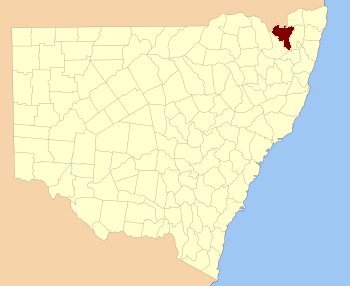
Location in New South Wales
|
|||||||||||||||
|
|||||||||||||||
Clive County is one of the 141 Cadastral divisions of New South Wales.
The name is of unknown origin.
Parishes
Clive County consists of the following parishes:
| Parish | LGA | Coordinates | Towns |
|---|---|---|---|
| Addison | Tenterfield | 29°05′54″S 151°55′04″E / 29.09833°S 151.91778°E | |
| Angoperran | Tenterfield | 29°21′54″S 151°56′04″E / 29.36500°S 151.93444°E | |
| Annandale | Tenterfield | 29°12′54″S 151°49′04″E / 29.21500°S 151.81778°E | |
| Bajimba | Tenterfield | 29°19′54″S 152°15′04″E / 29.33167°S 152.25111°E | |
| Ballandean | Tenterfield | 28°57′54″S 151°57′04″E / 28.96500°S 151.95111°E | Jennings |
| Barney Downs | Tenterfield | 28°59′54″S 152°07′04″E / 28.99833°S 152.11778°E | Barney Downs |
| Bates | Tenterfield | 29°12′54″S 151°44′04″E / 29.21500°S 151.73444°E | |
| Binghi | Tenterfield | 29°08′54″S 151°37′04″E / 29.14833°S 151.61778°E | |
| Binny | Glen Innes Severn | 29°30′54″S 152°14′04″E / 29.51500°S 152.23444°E | |
| Blain | Tenterfield | 29°10′54″S 151°28′04″E / 29.18167°S 151.46778°E | |
| Bloxsome | Tenterfield | 29°03′54″S 152°16′04″E / 29.06500°S 152.26778°E | |
| Bluff Land | Tenterfield | 29°09′54″S 152°03′04″E / 29.16500°S 152.05111°E | Bungulla |
| Bolivia | Tenterfield | 29°12′54″S 152°00′04″E / 29.21500°S 152.00111°E | Bolivia |
| Booroo | Tenterfield | 29°19′54″S 152°01′04″E / 29.33167°S 152.01778°E | |
| Butterleaf | Glen Innes Severn | 29°29′54″S 152°06′04″E / 29.49833°S 152.10111°E | |
| Capoompeta | Glen Innes Severn | 29°23′54″S 152°04′04″E / 29.39833°S 152.06778°E | Capoompeta |
| Cavendish | Tenterfield | 28°59′54″S 152°19′04″E / 28.99833°S 152.31778°E | |
| Clifton | Tenterfield | 29°03′54″S 151°50′04″E / 29.06500°S 151.83444°E | Woodside |
| Cowper | Tenterfield | 29°00′54″S 151°48′04″E / 29.01500°S 151.80111°E | |
| Dickson | Tenterfield | 29°04′54″S 152°09′04″E / 29.08167°S 152.15111°E | |
| Donaldson | Tenterfield | 29°01′54″S 151°39′04″E / 29.03167°S 151.65111°E | |
| Dumaresq | Tenterfield | 29°02′54″S 151°29′04″E / 29.04833°S 151.48444°E | |
| Eastern Water | Glen Innes Severn | 29°34′54″S 152°02′04″E / 29.58167°S 152.03444°E | |
| Farnell | Glen Innes Severn | 29°24′54″S 152°10′04″E / 29.41500°S 152.16778°E | |
| Forest Land | Tenterfield | 29°10′54″S 152°09′04″E / 29.18167°S 152.15111°E | |
| Frazer | Tenterfield | 29°10′54″S 151°49′04″E / 29.18167°S 151.81778°E | |
| Garrett | Glen Innes Severn | 29°33′54″S 152°06′04″E / 29.56500°S 152.10111°E | |
| Gibraltar | Tenterfield | 29°05′54″S 151°42′04″E / 29.09833°S 151.70111°E | |
| Glen Elgin | Glen Innes Severn | 29°35′54″S 152°08′04″E / 29.59833°S 152.13444°E | Glen Elgin |
| Glen Lyon | Tenterfield | 29°01′54″S 151°56′04″E / 29.03167°S 151.93444°E | |
| Goolamanger | Tenterfield | 29°16′54″S 152°10′04″E / 29.28167°S 152.16778°E | |
| Graham | Tenterfield | 28°59′54″S 151°58′04″E / 28.99833°S 151.96778°E | |
| Harden | Tenterfield | 28°55′54″S 151°38′04″E / 28.93167°S 151.63444°E | |
| Hillcrest | Tenterfield | 29°09′54″S 151°53′04″E / 29.16500°S 151.88444°E | |
| Irby | Tenterfield | 29°10′54″S 152°00′04″E / 29.18167°S 152.00111°E | |
| Jeffrey | Tenterfield | 28°56′54″S 151°40′04″E / 28.94833°S 151.66778°E | |
| Jondol | Tenterfield | 29°14′54″S 152°03′04″E / 29.24833°S 152.05111°E | Sandy Flat |
| Lawson | Tenterfield | 29°02′54″S 151°45′04″E / 29.04833°S 151.75111°E | |
| Lewis | Glen Innes Severn | 29°37′54″S 152°02′04″E / 29.63167°S 152.03444°E | |
| Limestone | Tenterfield | 29°00′54″S 151°45′04″E / 29.01500°S 151.75111°E | |
| Maclean | Tenterfield | 29°08′54″S 152°17′04″E / 29.14833°S 152.28444°E | |
| Mingoola | Tenterfield | 28°59′54″S 151°34′04″E / 28.99833°S 151.56778°E | Mingoola |
| Moogem | Glen Innes Severn | 29°25′54″S 152°15′04″E / 29.43167°S 152.25111°E | Moogem |
| Morven | Glen Innes Severn | 29°19′54″S 152°08′04″E / 29.33167°S 152.13444°E | |
| Perth | Tenterfield | 29°06′54″S 151°28′04″E / 29.11500°S 151.46778°E | |
| Rock Vale | Tenterfield | 29°12′54″S 151°38′04″E / 29.21500°S 151.63444°E | |
| Romney | Tenterfield | 29°21′40″S 151°51′03″E / 29.36111°S 151.85083°E | |
| Silent Grove | Tenterfield | 29°09′54″S 151°43′04″E / 29.16500°S 151.71778°E | Silent Grove |
| Strathearn | Tenterfield | 29°09′54″S 152°00′04″E / 29.16500°S 152.00111°E | |
| Tarban | Tenterfield | 28°58′34″S 151°41′04″E / 28.97611°S 151.68444°E | |
| Tenterfield | Tenterfield | 29°03′54″S 152°01′04″E / 29.06500°S 152.01778°E | Tenterfield |
| Timbarra | Tenterfield | 28°59′54″S 152°13′04″E / 28.99833°S 152.21778°E | Timbarra |
| Woodside | Tenterfield | 29°06′54″S 151°48′04″E / 29.11500°S 151.80111°E | |
| Wunglebong | Tenterfield | 29°11′54″S 152°12′04″E / 29.19833°S 152.20111°E |

All content from Kiddle encyclopedia articles (including the article images and facts) can be freely used under Attribution-ShareAlike license, unless stated otherwise. Cite this article:
Clive County, New South Wales Facts for Kids. Kiddle Encyclopedia.
